Ohio State Route 278
| ||||
|---|---|---|---|---|
 | ||||
| Route information | ||||
| Maintained by ODOT | ||||
| Length: | 27.61 mi[1] (44.43 km) | |||
| Existed: | 1930 – present | |||
| Major junctions | ||||
| South end: |
| |||
|
| ||||
| North end: |
| |||
| Location | ||||
| Counties: | Vinton, Hocking, Athens | |||
| Highway system | ||||
| ||||

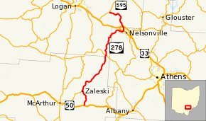
State Route 278 (SR 278) is a north–south state highway located in the southeastern part of the U.S. state of Ohio. The southern terminus of SR 278 is at US 50 approximately 4.75 miles (7.64 km) east of McArthur. The highway's northern terminus is at the T-intersection it has with SR 595 nearly 5.50 miles (8.85 km) northwest of Nelsonville.
Established in the early 1930s, SR 278 primarily connects rural communities in Vinton, Hocking, and Athens Counties. In Vinton County, it passes through and provides access to the Zaleski State Forest and Lake Hope State Park.
Route description
SR 278 travels through portions of the counties of Vinton, Hocking and Athens. There are no segments of SR 278 that are a part of the National Highway System.[2]
History
When it was designated in 1930, SR 278 was a spur route that ran along the segment of the current route between its current southern terminus at US 50 and the village of Zaleski.[3][4] In 1937, the highway was extended north from Zaleski, through Nelsonville up to its current northern terminus at SR 595.[5][6]
Major intersections
| County | Location | mi[1] | km | Destinations | Notes |
|---|---|---|---|---|---|
| Vinton | Madison Township | 0.00 | 0.00 | ||
| Zaleski | 3.42 | 5.50 | Northern terminus of SR 677 | ||
| Hocking | Starr Township | 13.24 | 21.31 | Southern end of SR 56 concurrency | |
| 13.33 | 21.45 | Northern end of SR 56 concurrency | |||
| Athens | Nelsonville | 21.60 | 34.76 | ||
| Hocking | Green Township | 27.61 | 44.43 | ||
1.000 mi = 1.609 km; 1.000 km = 0.621 mi
| |||||
References
- 1 2 Ohio Department of Transportation. "Technical Services Straight Line Diagrams". Retrieved 2010-06-22.
- ↑ National Highway System: Ohio (PDF) (Map). Federal Highway Administration. December 2003. Retrieved 2015-06-18.
- ↑ Ohio State Map (Map). Ohio Department of Transportation. 1929.
- ↑ Ohio State Map (Map). Ohio Department of Transportation. 1930.
- ↑ Ohio State Map (Map). Ohio Department of Transportation. 1936.
- ↑ Ohio State Map (Map). Ohio Department of Transportation. 1937.