Ohio State Route 285
| ||||
|---|---|---|---|---|
 | ||||
| Route information | ||||
| Maintained by ODOT | ||||
| Length: | 28.03 mi[1] (45.11 km) | |||
| Existed: | 1931 – present | |||
| Major junctions | ||||
| South end: |
| |||
|
| ||||
| North end: |
| |||
| Location | ||||
| Counties: | Noble, Guernsey | |||
| Highway system | ||||
| ||||

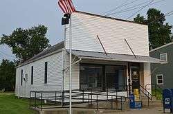
Post office in Lore City
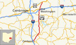
State Route 285 (SR 285) is a 28.03-mile (45.11 km) long state highway in eastern Ohio. The route runs from SR 821 in Caldwell, Ohio, the county seat of Noble County, to US 22 in Madison Township, Guernsey County.[2]
Route description
No segment of SR 285 is included within the National Highway System.[3]
History
SR 285 was first designated in 1931 as an gravel spur route from SR 265 near Lore City to Senecaville.[4][5] Within one year, the route was extended north via an dirt road to US 40 in Old Washington.[6] By 1935, the route was extended to its current northern terminus at US 22.[7] SR 285 was extended to its current southern terminus in Caldwell (at the time, US 21) by 1937.[8] No major changes have occurred to the route since that time.
Major intersections
| County | Location | mi[1] | km | Destinations | Notes |
|---|---|---|---|---|---|
| Noble | Caldwell | 0.00 | 0.00 | ||
| Sarahsville | 5.00 | 8.05 | Eastern terminus of SR 215 | ||
| 5.31 | 8.55 | Southern end of SR 146 concurrency | |||
| 5.36 | 8.63 | Northern end of SR 146 concurrency | |||
| Wayne Township | 13.84 | 22.27 | Western terminus of SR 566 | ||
| Guernsey | Senecaville | 15.04 | 24.20 | ||
| Center Township | 19.10 | 30.74 | |||
| Wills Township | 22.45 | 36.13 | Exit 186 (I-70), southern end of US 40 concurrency | ||
| Old Washington | 22.89 | 36.84 | Northern end of US 40 concurrency | ||
| Madison Township | 28.03 | 45.11 | |||
1.000 mi = 1.609 km; 1.000 km = 0.621 mi
| |||||
References
- 1 2 Ohio Department of Transportation. "Technical Services Straight Line Diagrams". Retrieved 2013-09-26.
- ↑ Google (September 26, 2013). "Ohio State Route 285" (Map). Google Maps. Google. Retrieved September 26, 2013.
- ↑ National Highway System: Ohio (PDF) (Map). Federal Highway Administration. October 1, 2012. Retrieved September 26, 2013.
- ↑ Map of Ohio Showing State Routes (MrSID) (Map). Cartography by ODHPW. Ohio Department of Highways and Public Works. 1930. Retrieved 2013-09-26.
- ↑ Map of Ohio Showing State Routes (MrSID) (Map). Cartography by ODHPW. ODHPW. 1931. Retrieved 2013-09-26.
- ↑ Map of Ohio Showing State Routes (MrSID) (Map). Cartography by ODHPW. ODHPW. 1932. Retrieved 2013-09-26.
- ↑ Map of Ohio Showing State Routes (MrSID) (Map). Cartography by ODHPW. ODHPW. 1935. Retrieved 2013-09-26.
- ↑ Map of Ohio Showing State Routes (MrSID) (Map). Cartography by ODHPW. ODHPW. 1937. Retrieved 2013-09-26.
This article is issued from Wikipedia - version of the 7/10/2015. The text is available under the Creative Commons Attribution/Share Alike but additional terms may apply for the media files.