Ohio State Route 324
| ||||
|---|---|---|---|---|
 | ||||
| Route information | ||||
| Maintained by ODOT | ||||
| Length: | 4.44 mi[1] (7.15 km) | |||
| Existed: | 1932[2][3] – present | |||
| Major junctions | ||||
| South end: |
| |||
| North end: |
| |||
| Location | ||||
| Counties: | Vinton | |||
| Highway system | ||||
| ||||

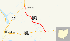
State Route 324 (SR 324) is a north–south state highway in the southern portion of the U.S. state of Ohio. The southern terminus of SR 324 is at a T-intersection with SR 160 about 4.50 miles (7.24 km) east of Hamden. Its northern terminus is at SR 93 nearly 4 miles (6.4 km) northeast of Hamden.
Route description
All of SR 324 is nestled within the confines of Clinton Township in the southeastern portion of Vinton County. It begins at a T-intersection with SR 160 approximately 4.50 miles (7.24 km) east of Hamden. For the majority of its length, SR 324 travels in a northwesterly fashion. The highway starts out traversing heavily wooded terrain, but soon transitions into a more open landscape. A few homes also appear along the way. Further along, the terrain starts to vary more, with a blend of forest and field appearing for much of the remainder of the length of SR 324. It turns north into the hamlet of Dundas, and passes a number of homes just prior to bending to the northwest, after which it crosses a set of railroad tracks and arrives at its endpoint at its junction with SR 93.[4]
SR 324 is not a route that is included within the National Highway System.[5]
History
SR 324 was established in 1932. For the duration of its history, this state highway has maintained the same routing within the southeastern quadrant of Vinton County. The only change over the years has been that the highway originally meeting SR 324 at its northern terminus was not SR 93, but rather its predecessor, SR 75. SR 160 has always been the intersecting highway at the southern terminus of SR 324.[2][3]
Major intersections
The entire route is in Clinton Township, Vinton County.
| mi[1] | km | Destinations | Notes | ||
|---|---|---|---|---|---|
| 0.00 | 0.00 | ||||
| 4.44 | 7.15 | ||||
| 1.000 mi = 1.609 km; 1.000 km = 0.621 mi | |||||
References
- 1 2 "DESTAPE - Vinton County" (PDF). Ohio Department of Transportation. June 24, 2015. Retrieved November 1, 2015.
- 1 2 Map of Ohio Showing State Highway System (MrSID) (Map). Cartography by ODOH. Ohio Department of Highways. 1931. Retrieved 2011-03-06.
- 1 2 Map of Ohio Showing State Highway System (MrSID) (Map). Cartography by ODOH. Ohio Department of Highways. 1932. Retrieved 2011-03-06.
- ↑ Google (November 1, 2015). "Overview Map of State Route 324" (Map). Google Maps. Google. Retrieved November 1, 2015.
- ↑ National Highway System: Ohio (PDF) (Map). Federal Highway Administration. December 2003. Retrieved 2011-03-06.