Ohio State Route 348
| ||||
|---|---|---|---|---|
 | ||||
| Route information | ||||
| Maintained by ODOT | ||||
| Length: | 32.24 mi[1] (51.89 km) | |||
| Existed: | 1935 – present | |||
| Major junctions | ||||
| West end: |
| |||
| East end: |
| |||
| Location | ||||
| Counties: | Adams, Scioto | |||
| Highway system | ||||
| ||||

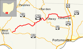
State Route 348 (SR 348) is an east–west state highway in the south central portion of the U.S. state of Ohio. Its western terminus is at State Route 125 approximately 6 miles (9.7 km) east of West Union, and its eastern terminus is at U.S. Route 23 just north of Lucasville – this is also the western terminus of State Route 728.
History
SR 348 was commissioned in 1935, routed on its current route, with the eastern terminus at its intersection with SR 73 in Otway.[2][3] In 1939 the route was extended east to U.S. Route 23, near Lucasville.[4][5]
Major intersections
| County | Location | mi[1] | km | Destinations | Notes |
|---|---|---|---|---|---|
| Adams | Tiffin Township | 0.00 | 0.00 | ||
| Jefferson Township | 12.80 | 20.60 | Eastern terminus of SR 781 | ||
| Scioto | Otway | 19.78 | 31.83 | Southern end of SR 73 concurrency | |
| 19.93 | 32.07 | Northern end of SR 73 concurrency | |||
| Morgan Township | 30.97 | 49.84 | |||
| Valley Township | 32.24 | 51.89 | Western terminus of SR 728 | ||
1.000 mi = 1.609 km; 1.000 km = 0.621 mi
| |||||
References
- 1 2 Ohio Department of Transportation. "Technical Services Straight Line Diagrams". Retrieved 2010-04-30.
- ↑ Ohio Department of Highways (1934). Map of Ohio Showing State Routes (MrSID) (Map). 1:760,320. Columbus: Ohio Department of Highways. OCLC 5673562, 7236991. Retrieved October 23, 2013.
- ↑ Ohio Department of Highways (1935). Official Highway Map of Ohio (MrSID) (Map). Columbus: Ohio Department of Highways. OCLC 5673562, 54667348. Retrieved October 23, 2013.
- ↑ Ohio Department of Highways (1938). Official Highway Map of Ohio (MrSID) (Map). 1:633,600. Columbus: Ohio Department of Highways. OCLC 5673562, 7453129. Retrieved October 23, 2013.
- ↑ Ohio Department of Highways (1939). Official Highway Map of Ohio (MrSID) (Map). 1:633,600. Columbus: Ohio Department of Highways. OCLC 5673562, 7408341. Retrieved October 23, 2013.
This article is issued from Wikipedia - version of the 8/28/2014. The text is available under the Creative Commons Attribution/Share Alike but additional terms may apply for the media files.