Ohio State Route 689
| ||||
|---|---|---|---|---|
 | ||||
| Route information | ||||
| Maintained by ODOT | ||||
| Length: | 7.52 mi[1] (12.10 km) | |||
| Existed: | 1937 – present | |||
| Major junctions | ||||
| South end: |
| |||
| North end: |
| |||
| Location | ||||
| Counties: | Vinton, Meigs | |||
| Highway system | ||||
| ||||

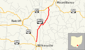
State Route 689 (SR 689) is a north–south state highway in the southern portion of the U.S. state of Ohio. Its southern terminus is at SR 160 a mile north of Wilkesville, and its northern terminus is at SR 32 about 6 miles (9.7 km) southwest of Albany.
Route description
SR 689 passes through two counties along its path, Vinton and Meigs. This state highway is not included within the National Highway System.[2]
History
SR 689 first appeared in 1937 along the routing that it currently occupies.[3][4] Originally, its northern terminus was at a two-lane SR 346, the predecessor to SR 32. In the early 1970s, the construction of the Appalachian Highway (originally numbered SR 346 at its completion, later renumbered to SR 32) truncated the highway very slightly at its northern terminus.[5][6] No other major changes have occurred to the routing since then.
Major intersections
| County | Location | mi[1] | km | Destinations | Notes |
|---|---|---|---|---|---|
| Vinton | Wilkesville Township | 0.00 | 0.00 | ||
| Meigs | Columbia Township | 7.52 | 12.10 | ||
| 1.000 mi = 1.609 km; 1.000 km = 0.621 mi | |||||
References
- 1 2 Ohio Department of Transportation. "Technical Services Straight Line Diagrams". Retrieved 2010-05-09.
- ↑ National Highway System: Ohio (PDF) (Map). Federal Highway Administration. December 2003. Retrieved 2010-08-21.
- ↑ Ohio State Map (Map). Ohio Department of Transportation. 1936.
- ↑ Ohio State Map (Map). Ohio Department of Transportation. 1937.
- ↑ 1969 Official Ohio Highway Map (MrSID) (Map). Cartography by P.E. Masheter, Director. ODOH. 1969. Retrieved September 22, 2013.
- ↑ 1971 Ohio Highway Map (MrSID) (Map). Cartography by J. Phillip Richley, Director. ODOH. 1971. Retrieved August 19, 2013.