Oklahoma State Highway 80
| ||||
|---|---|---|---|---|
 | ||||
| Route information | ||||
| Maintained by ODOT | ||||
| Length: | 20.4 mi (32.8 km) | |||
| Major junctions | ||||
| south end: |
| |||
| north end: |
| |||
| Highway system | ||||
| ||||

State Highway 80 is a north–south state highway in eastern Oklahoma. It runs from Ft. Gibson in Muskogee County to Hulbert in Cherokee County. It is 20.4 miles[1] (33 km) long and has one lettered spur route, SH-80A.
Route description
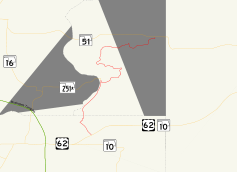
SH-80 begins at US-62/SH-10 just south of Ft. Gibson. After heading through Ft. Gibson, it enters Cherokee County. It roughly parallels the Cherokee/Wagoner County line before meeting the east end of State Highway 251A. It then heads east before curving back north and zig-zagging to its northern end with SH-51.
Junction list
| County | Location | mi[1] | km | Destinations | Notes |
|---|---|---|---|---|---|
| Muskogee | Ft. Gibson | 0.0 | 0.0 | Southern terminus | |
| 1.9 | 3.1 | ||||
| 2.2 | 3.5 | ||||
| Cherokee | | 7.0 | 11.3 | ||
| Hulbert | 20.4 | 32.8 | |||
| 1.000 mi = 1.609 km; 1.000 km = 0.621 mi | |||||
SH-80A

SH-80A is an alternate route of SH-80 through the east side of Ft. Gibson. It is a half mile[2] (0.8 km) in length. It connects to SH-80 at both ends.
References
- 1 2 Stuve, Eric. "OK-80". OKHighways.com. Retrieved 2007-08-10.
- ↑ Stuve, Eric. "OK-80a". OKHighways.com. Retrieved 2007-08-10.
External links
This article is issued from Wikipedia - version of the 10/23/2016. The text is available under the Creative Commons Attribution/Share Alike but additional terms may apply for the media files.