Old Trails Bridge
|
Old Trails Bridge | |
|
Photo in 2002 | |
  | |
| Location | Abandoned US 66 over the Colorado River, Topock, Arizona |
|---|---|
| Coordinates | 34°42′57″N 114°29′5″W / 34.71583°N 114.48472°WCoordinates: 34°42′57″N 114°29′5″W / 34.71583°N 114.48472°W |
| Area | 0.3 acres (0.12 ha) |
| Built | 1915-16 |
| Built by | Sourwine,S.A.; Et al. |
| Architectural style | Brace-ribbed through arch |
| MPS | Vehicular Bridges in Arizona MPS |
| NRHP Reference # | 88001676[1] |
| Added to NRHP | September 30, 1988 |
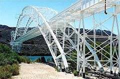
The Old Trails Bridge over the Colorado River, brought a now-abandoned portion of U.S. Route 66 across from Needles, California to Topock, Arizona. It is a brace-ribbed through arch bridge that was built in 1915-1916.[2] It served as a highway bridge until Interstate 40 bridge was built, then was converted to a pipeline bridge.
It has also been known as Topock Bridge and as Needles Bridge. It was listed on the National Register of Historic Places in 1988.[1][2]
References
- 1 2 National Park Service (2010-07-09). "National Register Information System". National Register of Historic Places. National Park Service.
- 1 2 Clayton B. Fraser (April 1, 1987). "HABS/HAER Inventory: Old Trails Bridge / Topock Bridge / Needles Bridge" (PDF). National Park Service. and accompanying photos
External links
- Photo at Flickr, in higher resolution
| Topics | |
|---|---|
| Lists by states |
|
| Lists by insular areas | |
| Lists by associated states | |
| Other areas | |
| |
This article is issued from Wikipedia - version of the 11/30/2016. The text is available under the Creative Commons Attribution/Share Alike but additional terms may apply for the media files.