Olentangy River
| Olentangy River | |
|---|---|
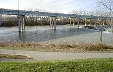 State Route 315 passing over the Olentangy in Columbus in 2002 | |
| Basin | |
| Main source |
~ 2 mi (3.2 km) North east of Galion. ~ 1,190 ft (360 m)[1] |
| River mouth |
Scioto River at Columbus ~ 710 ft (220 m)[2] |
| Basin size | 543 sq mi (1,410 km2)[3] |
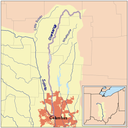
The Olentangy River /oʊlənˈtændʒi/ is a 97-mile-long (156 km)[4] tributary of the Scioto River in Ohio.
It was originally called keenhongsheconsepung, a Delaware word literally translated as "stone for your knife stream", based on the flint found along its shores. Early settlers to the region translated this into "Whetstone River". In 1833, the Ohio General Assembly passed legislation intending to restore the original Native American names to some Ohio waterways, but mistakenly gave Whetstone River the name "Olentangy"—Delaware for "river of the red face paint"—which had actually belonged to what is now known as Big Darby Creek.
The Olentangy River rises in Crawford County approximately 2 mi (3.2 km) northeast of Galion, flowing through Galion and northwest towards Bucyrus, where it then turns south and flows through Eastern Marion County, Ohio (where it is still locally known as the Whetstone River) before flowing south into Delaware County. The river continues southward towards the communities of Delaware, Powell, Worthington, and the village of Riverlea, before reaching Columbus and the campus of the Ohio State University, before joining with the Scioto River in downtown Columbus.
The Delaware State Park Reservoir, also known as Delaware Lake, was constructed along the Olentangy River in 1951. The reservoir is located 5 miles north of the city of Delaware, and was built by the U.S. Army Corps of Engineers for flood control purposes. On January 13, 2005, Delaware Dam was nearly overtopped. The water level came within less than 1 foot of the top of the dam, requiring the main spill gates to be opened before it began dropping.[5]
The Olentangy River is the primary source of drinking water for much of Delaware County. Both the City of Delaware and Del-Co Water Company, the supplier of drinking water to most of rural Delaware County (and other communities beyond), draw the majority of their water supplies from the Olentangy system.
Twenty-two miles of the Olentangy have been designated a State Scenic River by the Ohio Department of Natural Resources, Division of Natural Areas & Preserves.[6]
Variant names
The Olentangy River has also been known as Keenhongsheconsepung, Oleutangy, Whetstone Creek, Whetstone River, and Whitestone Creek.[7]
River restoration
In 2012 the Ohio EPA and the City of Columbus began to remove some of the lowhead dams that cross the river. Work started with removing the 5th Avenue Dam. The river is now about half of its former width. Work continues to restore the banks and clean the area.[8][9][10][11]
See also
References
- ↑ U.S. Geological Survey. Blooming Grove quadrangle, Ohio. 1:24,000. 7.5 Minute Series. Washington D.C.: USGS, 1988.
- ↑ U.S. Geological Survey. Southwest Columbus quadrangle, Ohio. 1:24,000. 7.5 Minute Series. Washington D.C.: USGS, 1995.
- ↑ "Map of Ohio watersheds".
- ↑ "The National Map". U.S. Geological Survey. Retrieved Feb 14, 2011.
- ↑ "Delaware Dam nearly overtopped on January 13, 2005".
- ↑ "Olentangy State Scenic River".
- ↑ U.S. Geological Survey Geographic Names Information System: Olentangy River
- ↑ http://fifthavenuedam.olentangywatershed.org/
- ↑ http://www.columbus.gov/5thAveDam/
- ↑ http://water.epa.gov/polwaste/nps/success319/upload/oh_olentangy.pdf
- ↑ http://epa.ohio.gov/portals/35/nps/319DOCS/OlentangyRiverSuccess2010.pdf
External links
- Friends of the Lower Olentangy Watershed
- Delaware Dam level and outflow graph
- Olentangy River Level Gauge at Worthington, OH
Coordinates: 39°57′57″N 83°01′00″W / 39.9659°N 83.0166°W