Omeonga

Omeonga is a town in the Sankuru District, Kasai-Oriental, Democratic Republic of the Congo. It lies around 25 miles (40 km) south southeast of the nearest large town, Katako-Kombe. The Lomami river also passes nearby.
Chiefs or possessors of the name Omeonga are considered royal. It is also a name meaning "Man of Pillars" or "Noble".
Impact crater
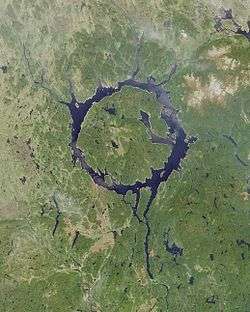
The town lies near the center of a 30 km diameter depression, which is a proposed but unconfirmed ancient impact crater called the "Wembo-Nyama ring structure".[1][2][3] The roundness of the ring is underlined by a tributary of the Lomami river.[4] A similar visual effect can be seen with Manicouagan crater where a ring of water surrounds the central René-Levasseur Island.
See also
References
- ↑ "Ring may be giant 'impact crater'". BBC News. 2010-03-10. Retrieved 2010-05-08.
- ↑ G. Monegato; M. Massironi & E. Martellato (2010). "The Ring Structure of Wembo-Nyama (Eastern Kasai, R.D. Congo): A Possible Impact Crater in Central Africa" (PDF). Lunar and Planetary Science. Lunar and Planetary Institute. XLI.
- ↑ The Full Catalogue of the Earth's Impact structures. Siberian Center For Global Catastrophes. Department of Mathematical Problems of Geophysics, Institute of Computational Mathematics and Mathematical Geophysics. Siberian Division, Russian Academy of Sciences.
- ↑ E. Martellato; G. Cremonese; M. Massironi; and G. Monegato (2010). Omeonga (Wembo-Nyama): Isale Hydrocode Simulations, Nördlingen Ries Crater Workshop
External links
Coordinates: 03°28′0″S 24°24′0″E / 3.46667°S 24.40000°E