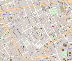
OpenStreetMap
|
| |
|
OSM homepage | |
Type of site | Collaborative mapping |
|---|---|
| Available in | At least 151 site translations and unlimited map languages[1] |
| Owner | OpenStreetMap Community. Project support by OpenStreetMap Foundation[2] |
| Created by | Steve Coast |
| Slogan(s) | The Free Wiki World Map |
| Website | openstreetmap.org |
| Alexa rank |
|
| Commercial | No |
| Registration | Required for contributors |
| Users | 3,047,649[3] |
| Launched | 9 August 2004[4] |
| Current status | Active |
Content license | ODbL |
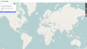
OpenStreetMap (OSM) is a collaborative project to create a free editable map of the world. The creation and growth of OSM has been motivated by restrictions on use or availability of map information across much of the world, and the advent of inexpensive portable satellite navigation devices.[5] OSM is considered a prominent example of volunteered geographic information.
Created by Steve Coast in the UK in 2004, it was inspired by the success of Wikipedia[6] and the predominance of proprietary map data in the UK and elsewhere.[7] Since then, it has grown to over 2 million registered users,[8] who can collect data using manual survey, GPS devices, aerial photography, and other free sources. These crowdsourced data are then made available under the Open Database Licence. The site is supported by the OpenStreetMap Foundation, a non-profit organisation registered in England and Wales.
Rather than the map itself, the data generated by the OpenStreetMap project are considered its primary output. The data are then available for use in both traditional applications, like its usage by Craigslist, OsmAnd, Geocaching, MapQuest Open, JMP statistical software, and Foursquare to replace Google Maps, and more unusual roles like replacing default data included with GPS receivers.[9] OpenStreetMap data have been favourably compared with proprietary datasources,[10] though data quality varies worldwide.[11][12]
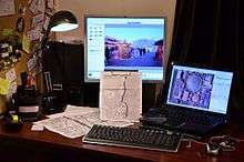
History
.jpg)
Steve Coast founded the project in 2004, initially focusing on mapping the United Kingdom. In the UK and elsewhere, government-run and tax-funded projects like the Ordnance Survey created massive datasets but failed to freely and widely distribute them. In April 2006, the OpenStreetMap Foundation was established to encourage the growth, development and distribution of free geospatial data and provide geospatial data for anybody to use and share. In December 2006, Yahoo! confirmed that OpenStreetMap could use its aerial photography as a backdrop for map production.[13]
In April 2007, Automotive Navigation Data (AND) donated a complete road data set for the Netherlands and trunk road data for India and China to the project[14] and by July 2007, when the first OSM international The State of the Map conference was held, there were 9,000 registered users. Sponsors of the event included Google, Yahoo! and Multimap. In October 2007, OpenStreetMap completed the import of a US Census TIGER road dataset.[15] In December 2007, Oxford University became the first major organisation to use OpenStreetMap data on their main website.[16]
Ways to import and export data have continued to grow – by 2008, the project developed tools to export OpenStreetMap data to power portable GPS units, replacing their existing proprietary and out-of-date maps.[17] In March, two founders announced that they have received venture capital funding of 2.4M euros for CloudMade, a commercial company that uses OpenStreetMap data.[18] In November 2010, Bing changed their licence to allow use of their satellite imagery for making maps.[19]
In 2012, the launch of pricing for Google Maps led several prominent websites to switch from their service to OpenStreetMap and other competitors.[20] Chief amongst these were Foursquare, Craigslist who adopted OpenStreetMap, and Apple, which ended a contract with Google and launched a self-built mapping platform which uses TomTom and OpenStreetMap data.[21]
Map production
Map data is collected from scratch by volunteers performing systematic ground surveys using tools such as a handheld GPS unit, a notebook, digital camera, or a voice recorder. The data is then entered into the OpenStreetMap database. Mapathon competition events are also held by OpenStreetMap team and by non-profit organisations and local governments to map a particular area.
The availability of aerial photography and other data from commercial and government sources has added important sources of data for manual editing and automated imports. Special processes are in place to handle automated imports and avoid legal and technical problems.[22]
Software for editing maps
Editing of maps can be done using the default web browser editor called iD, an HTML5 application using d3.js and written by MapBox.[23] The earlier Flash-based application Potlatch is retained for intermediate-level users. JOSM and Merkaartor are more powerful desktop editing applications that are better suited for advanced users.
The GNOME Maps application developed for the GNOME desktop environment, which runs on many Linux operating systems, will as of version 3.20 include the option to edit OSM.
Contributors
The project has a geographically diverse user-base, due to emphasis of local knowledge and ground truth in the process of data collection. Many early contributors are cyclists who survey with and for bicycles, charting cycleroutes and navigable trails.[24] Others are GIS professionals who contribute data with Esri tools.[25]
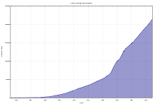
By August 2008, shortly after the second The State of the Map conference was held, there were over 50,000 registered contributors; by March 2009, there were 100,000 and by the end of 2009 the figure was nearly 200,000. In April 2012, OpenStreetMap cleared 600,000 registered contributors.[26] On 6 January 2013, OpenStreetMap reached 1 million registered users.[27] Around 30% of users have contributed at least one point to the OpenStreetMap database.[28]
Surveys and personal knowledge
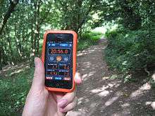
Ground surveys are performed by a mapper, on foot, bicycle, or in a car, motorcycle or boat. Map data are usually collected using a GPS unit, although this is not strictly necessary if an area has already been traced from satellite imagery.
Once the data has been collected, it is entered into the database by uploading it onto the project's website. At that point, no information about the kind of uploaded track is available – it could be e.g., a motorway, a footpath, or a river. Thus, in a second step, editing takes place using one of several purpose-built map editors (e.g., JOSM). This is usually done by the same mapper, sometimes by other contributors registered at OpenStreetMap.
As collecting and uploading data is separated from editing objects, contribution to the project is possible also without using a GPS unit. In particular, placing and editing objects such as schools, hospitals, taxi ranks, bus stops, pubs, etc. is done based on editors' local knowledge.
Some committed contributors adopt the task of mapping whole towns and cities, or organising mapping parties to gather the support of others to complete a map area. A large number of less active users contribute corrections and small additions to the map.
Government data
Some government agencies have released official data on appropriate licences. This includes the United States, where works of the federal government are placed under public domain.[29]
In the United States, OSM uses Landsat 7 satellite imagery, Prototype Global Shorelines from NOAA, and TIGER from the Census. In the UK, some Ordnance Survey OpenData is imported, while Natural Resources Canada's CanVec vector data and GeoBase provide landcover and streets.
Out-of-copyright maps can be good sources of information about features that do not change frequently. Copyright periods vary, but in the UK Crown copyright expires after 50 years and hence Ordnance Survey maps until the 1960s can legally be used. A complete set of UK 1 inch/mile maps from the late 1940s and early 1950s has been collected, scanned, and is available online as a resource for contributors.
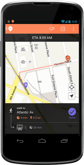
Route planning
In February 2015, OpenStreetMap added route planning functionality to the map on its official website. The routing uses external services, namely OSRM, GraphHopper and MapQuest.[30]
There are other routing providers and applications listed in the official Routing wiki.
Map usage
Software for viewing maps
- Web browser
- Data provided by the OpenStreetMap project can be viewed in a web browser with JavaScript support via Hypertext Transfer Protocol (HTTP) on its official website.
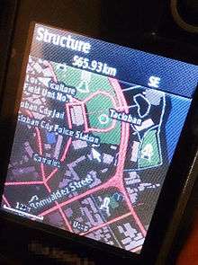
- OsmAnd
- OsmAnd is free software for Android and iOS mobile devices that can use offline vector data from OSM. It also supports layering OSM vector data with prerendered raster map tiles from OpenStreetMap and other sources.
- GNOME Maps
- GNOME Maps is a graphical front-end written in JavaScript and introduced in GNOME 3.10. It provides a mechanism to find the user's location with the help of GeoClue, finds directions via GraphHopper and it can deliver a list as answer to queries.
- Marble
- Marble is a KDE virtual globe application which received support for OpenStreetMap.
- FoxtrotGPS
- FoxtrotGPS is a GTK+-based map viewer, that is especially suited to touch input.[31] It is available in the SHR or Debian repositories.[32]
The web site OpenStreetMap.org provides a slippy map interface based on the Leaflet javascript library (and formerly built on OpenLayers), displaying map tiles rendered by the Mapnik rendering engine, and tiles from other sources including OpenCycleMap.org.[35]
Custom maps can also be generated from OSM data through various software including Mapnik, MapBox Studio, Mapzen's Tangrams.
OpenStreetMap maintains lists of online and offline routing engines available, such as the Open Source Routing Machine.[36] OSM data is popular with routing researchers, and is also available to open-source projects and companies to build routing applications (or for any other purpose).
Humanitarian aid
The 2010 Haiti earthquake has established a model for non-governmental organisations (NGOs) to collaborate with international organisations. OpenStreetMap and Crisis Commons volunteers[38] using available satellite imagery[39] to map the roads, buildings and refugee camps of Port-au-Prince in just two days, building "the most complete digital map of Haiti's roads".[40]
The resulting data and maps have been used by several organisations providing relief aid, such as the World Bank,[41] the European Commission Joint Research Centre,[42] the Office for the Coordination of Humanitarian Affairs,[43] UNOSAT[43] and others.[44]
NGOs, like the Humanitarian OpenStreetMap Team and others, have worked with donors like United States Agency for International Development (USAID) to map other parts of Haiti and parts of many other countries, both to create map data for places that were blank, and to engage and build capacity of local people.[45]
After Haiti, the OpenStreetMap community continued mapping to support humanitarian organisations for various crises and disasters. After the Northern Mali conflict (January 2013),[46] Typhoon Haiyan in the Philippines (November 2013),[47][48] and the Ebola virus epidemic in West Africa (March 2014),[49] the OpenStreetMap community has shown it can play a significant role in supporting humanitarian organisations.
The Humanitarian OpenStreetMap Team acts as an interface between the OpenStreetMap community and the humanitarian organisations.
Along with post-disaster work, the Humanitarian OpenStreetMap Team has worked to build better risk models and grow the local OpenStreetMap communities in multiple countries including Uganda, Senegal, the Democratic Republic of the Congo in partnership with the Red Cross, Médecins Sans Frontières,[50] World Bank,[51] and other humanitarian groups.[52]
State of the Map
Since 2007, the OSM community has held an annual, international conference, the State of the Map. Venues have been:
- 2007: Manchester, UK[53]
- 2008: Limerick, Ireland[54]
- 2009: Amsterdam, Netherlands[55]
- 2010: Girona, Spain[56]
- 2011: Denver, USA[57]
- 2012: Tokyo, Japan[58]
- 2013: Birmingham, UK[59]
- 2014: Buenos Aires, Argentina[60]
- 2015: (none)[61]
- 2016: Brussels, Belgium[62]
Legal aspects
Licensing terms
OpenStreetMap data was originally published under the Creative Commons Attribution-ShareAlike licence (CC BY-SA) with the intention of promoting free use and redistribution of the data. In September 2012, the licence was changed to the Open Database Licence (ODbL) published by Open Data Commons (ODC) in order to more specifically define its bearing on data rather than representation.[63]
As part of this relicensing process, some of the map data was removed from the public distribution. This included all data contributed by members that did not agree to the new licensing terms, as well as all subsequent edits to those affected objects. It also included any data contributed based on input data that was not compatible with the new terms. Estimates suggested that over 97% of data would be retained globally, however certain regions would be affected more than others, such as in Australia where 24 to 84% of objects would be retained, depending on the type of object.[64] Ultimately, more than 99% of the data was retained, with Australia and Poland being the countries most severely affected by the change.[65]
All data added to the project needs to have a licence compatible with the Open Database Licence. This can include out-of-copyright information, public domain or other licences. Contributors agree to a set of terms which require compatibility with the current licence. This may involve examining licences for government data to establish whether it is compatible.
Software used in the production and presentation of OpenStreetMap data is available from many different projects and each may have its own licensing. The application – what users access to edit maps and view changelogs, is powered by Ruby on Rails. The application also uses PostgreSQL for storage of user data and edit metadata. The default map is rendered by Mapnik, stored in PostGIS, and powered by an Apache module called mod_tile. Certain parts of the software, such as the map editor Potlatch2, have been made available as public domain.[66]
Commercial data
Some OpenStreetMap data is supplied by companies that choose to freely license either actual street data or satellite imagery sources from which OSM contributors can trace roads and features.
Notably, Automotive Navigation Data provided a complete road data set for Netherlands and details of trunk roads in China and India. In December 2006, Yahoo! confirmed that OpenStreetMap was able to make use of their vertical aerial imagery and this photography was available within the editing software as an overlay. Contributors could create their vector based maps as a derived work, released with a free and open licence,[13] until the shutdown of the Yahoo! Maps API on 13 September 2011.[67] In November 2010, Microsoft announced that the OpenStreetMap community could use Bing vertical aerial imagery as a backdrop in its editors.[68] For a period from 2009 to 2011, NearMap Pty Ltd made their high-resolution PhotoMaps (of major Australian cities, plus some rural Australian areas) available for deriving OpenStreetMap data under a CC BY-SA licence.[69]
Operation
While OpenStreetMap aims to be a central data source, its map rendering and aesthetics are meant to be only one of many options, some which highlight different elements of the map or emphasise design and performance.
Data format
OpenStreetMap uses a topological data structure, with four core elements (also known as data primitives):
- Nodes are points with a geographic position, stored as coordinates (pairs of a latitude and a longitude) according to WGS 84.[70] Outside of their usage in ways, they are used to represent map features without a size, such as points of interest or mountain peaks.
- Ways are ordered lists of nodes, representing a polyline, or possibly a polygon if they form a closed loop. They are used both for representing linear features such as streets and rivers, and areas, like forests, parks, parking areas and lakes.
- Relations are ordered lists of nodes, ways and relations (together called "members"), where each member can optionally have a "role" (a string). Relations are used for representing the relationship of existing nodes and ways. Examples include turn restrictions on roads, routes that span several existing ways (for instance, a long-distance motorway), and areas with holes.
- Tags are key-value pairs (both arbitrary strings). They are used to store metadata about the map objects (such as their type, their name and their physical properties). Tags are not free-standing, but are always attached to an object: to a node, a way or a relation. A recommended ontology of map features (the meaning of tags) is maintained on a wiki.
Data storage
The OSM data primitives are stored and processed in different formats.
The main copy of the OSM data is stored in OSM's main database. The main database is a PostgreSQL database, which has one table for each data primitive, with individual objects stored as rows.[71] All edits happen in this database, and all other formats are created from it.
For data transfer, several database dumps are created, which are available for download. The complete dump is called planet.osm. These dumps exist in two formats, one using XML and one using the Protocol Buffer Binary Format (PBF).
The LinkedGeoData[72] data uses the GeoSPARQL and well-known text (WKT) RDF vocabularies to represent OpenStreetMap data. It is a work of the Agile Knowledge Engineering and Semantic Web (AKSW) research group at the University of Leipzig, a group mostly known for DBpedia.
Commercial services
A variety of popular services incorporate some sort of geolocation or map-based component. Notable services using OSM for this include:
- Apple Inc. unexpectedly created an OpenStreetMap-based map for iPhoto for iOS on 7 March 2012, and launched the maps without properly citing the data source – though this was corrected in 1.0.1. OpenStreetMap is one of the many cited sources for Apple's custom maps in iOS 6, though the majority of map data is provided by TomTom.
- Flickr uses OpenStreetMap data for various cities around the world, including Baghdad, Beijing, Kabul, Santiago, Sydney and Tokyo.[73][74][75] In 2012, the maps switched to use Nokia data primarily, with OSM being used in areas where the commercial provider lacked performance.[76]
- MapQuest announced a service based on OpenStreetMap in 2010, which eventually became MapQuest Open.[77]
- On 29 February 2012, Foursquare started using OpenStreetMap via MapBox's rendering and infrastructure.[78]
- Craigslist switched to OpenStreetMap in 2012, rendering their own tiles based on the data.[79]
- In 2015, Mapworks incorporated the OSM Data set for rendering under a vector publication method. This allows basic GIS analysis capabilities to be performed at web clients supporting HTML5.
- In September 2009, Hasbro, the toy company behind the real estate-themed board game Monopoly, launched Monopoly City Streets, a massively multiplayer online game (MMORPG) which allowed players to "buy" streets all over the world. The game used map tiles from Google Maps and the Google Maps API to display the game board, but the underlying street data was obtained from OpenStreetMap.[80] The online game was a limited time offering, its servers were shut down in the end of January 2010.[81]
- Moovit uses maps based on OpenStreetMap in their free mobile application for public transit navigation.[82]
- Wikipedia uses OpenStreetMap data to render custom maps used by the articles. Many languages are included in the WIWOSM project (Wikipedia Where in OSM) which aims to show OSM objects on a slippy map, directly visible on the article page.[83]
- Wikivoyage uses OpenStreetMap as a locator map for cities and travel points of interest.
- Dublin-based indie games developer Ballardia launched World of the Living Dead: Resurrection in October 2013,[84] which has incorporated OpenStreetMap into its game engine, along with census information to create a browser-based game mapping over 14,000 square kilometres of greater Los Angeles and survival strategy gameplay. Its previous incarnation had used Google Maps,[85] which had proven incapable of supporting high volumes of players, so during 2013 they shut down the Google Maps version and ported the game to OSM.[86]
- Geotab uses OpenStreetMap data in their Vehicle Tracking Software platform, MyGeotab.[87]
- Strava switched to OpenStreetMap rendered and hosted by Mapbox from Google Maps in July 2015.[88]
See also
- Volunteered geographic information
- Collaborative mapping
- Neogeography
- Counter-mapping
- Turn-by-turn navigation
- Comparison of web map services
- Mobile applications: MAPS.ME, OsmAnd, Oruxmaps
- Alternatives: Google Map Maker, Wikimapia, Yandex Public Map
References
- ↑ "Translating OpenStreetMap". Retrieved 27 July 2015.
- ↑ "FAQ". OpenStreetMap Wiki. Retrieved 15 April 2011.
- ↑ "Stats". Retrieved 12 September 2016.
- ↑ "OpenStreetMap.com WHOIS, DNS, & Domain Info - DomainTools". WHOIS. Retrieved 2016-08-27.
- ↑ Anderson, Mark (18 October 2006). "Global Positioning Tech Inspires Do-It-Yourself Mapping Project". National Geographic News. Retrieved 25 February 2012.
- ↑ Lardinois, Frederic (9 August 2014). "For the Love of Mapping Data". TechCrunch.
- ↑ Frederick Ramm; Jochen Topf; Steve Chilton (2011). OpenStreetMap: Using and Enhancing the Free Map of the World. UIT Cambridge.
- ↑ Neis, Pascal,; Zipf, Alexander, (2012), "Analyzing the Contributor Activity of a Volunteered Geographic Information Project — The Case of OpenStreetMap", ISPRS Int. J. Geo-Inf., 1 (2): 146–165, doi:10.3390/ijgi1020146
- ↑ "OSM Map on Garmin". OpenStreetMap Wiki. Retrieved 25 July 2014.
- ↑ Zielstra, Dennis. "Comparing Shortest Paths Lengths of Free and Proprietary Data for Effective Pedestrian Routing in Street Networks" (PDF). University of Florida, Geomatics Program. Retrieved 14 November 2012.
- ↑ Haklay, M. (2010). How good is volunteered geographical information? A comparative study of OpenStreetMap and Ordnance Survey datasets. Environment and Planning B: Planning and Design. volume 37, pages 682–703
- ↑ Coleman, D. (2013). Potential Contributions and Challenges of VGI for Conventional Topographic Base-Mapping Programs. In Sui, D., Elwood, S and Goodchild, M. (Eds.), *Crowdsourcing Geographic Knowledge: Volunteered Geographic Information (VGI) in Theory and Practice* (pp. 245–264). New York, London: Springer Science+Business Media Dordrecht.
- 1 2 Coast, Steve (4 December 2006). "Yahoo! aerial imagery in OSM". OpenGeoData. Retrieved 15 April 2011.
- ↑ Coast, Steve (4 July 2007). "AND donate entire Netherlands to OpenStreetMap". OpenGeoData. Retrieved 15 April 2011.
- ↑ Willis, Nathan (11 October 2007). "OpenStreetMap project imports US government maps". Linux.com. Retrieved 16 April 2011.
- ↑ Batty, Peter (3 December 2007). "Oxford University using OpenStreetMap data". Geothought. Retrieved 16 April 2011.
- ↑ Fairhurst, Richard (13 January 2008). "Cycle map on your GPS". Système D. Retrieved 16 April 2011.
- ↑ "We're funded!". CloudMade. 17 March 2008. Retrieved 16 April 2011.
- ↑ "Bing engages open maps community". 23 November 2010.
- ↑ Fossum, Mike (20 March 2012). "Websites Bypassing Google Maps Due to Fees". Retrieved 13 November 2012.
- ↑ Ingraham, Nathan (11 June 2012). "Apple using TomTom and OpenStreetMap data in iOS 6 Maps app". Retrieved 13 November 2012.
- ↑ "Import/Guidelines". OpenStreetMap. Retrieved 23 March 2015.
The import guidelines, along with the Automated Edits code of conduct, should be followed when importing data into the OpenStreetMap database as they embody many lessons learned throughout the history of OpenStreetMap. Imports should be planned and executed with more care and sensitive than other edits, because poor imports can have significant impacts on both existing data and local mapping community.
- ↑ Saman Bemel Benrud (31 January 2013). "A New Editor for OpenStreetMap: iD". Mapbox.
- ↑ "Key and More Info". OpenCycleMap. Retrieved 17 November 2012.
- ↑ Vines, Emily. "Esri Releases ArcGIS Editor for OpenStreetMap". Esri. Retrieved 17 November 2012.
- ↑ "Stats". OpenStreetMap Wiki. Retrieved 25 May 2014.
- ↑ Wood, Harry. "1 million OpenStreetMappers". OpenGeoData. Retrieved 7 January 2013.
- ↑ Neis, Pascal. "The OpenStreetMap Contributors Map aka Who's around me?". Retrieved 7 January 2013.
- ↑ See Copyright status of work by the U.S. government for more details.
- ↑ "Routing on OpenStreetMap.org | OpenStreetMap Blog". Retrieved 28 April 2015.
- ↑ "FoxtrotGPS homepage".
- ↑ "FoxtrotGPS in Debian".
- ↑ "Emerillon in Debian repositories".
- ↑ "Emerillon homepage".
- ↑ opencyclemap.org
- ↑ Filney, Klint (11 November 2013). "Out in the Open: How to Get Google Maps Directions Without Google". Wired. Retrieved 11 November 2013.
- ↑ "OpenStreetMap Activities for Typhoon Haiyan (2013)". Neis-one.org. Retrieved 24 April 2015.
- ↑ crisiscommons.org
- ↑ Forrest, Brady (1 February 2010). "Technology Saves Lives In Haiti". Forbes.com. Retrieved 15 April 2011.
- ↑ "Digital Help for Haiti". The New York Times. 27 January 2010. Retrieved 15 April 2011.
- ↑ Turner, Andrew (3 February 2010). "World Bank Haiti Situation Room – featuring OSM".
- ↑ European Commission Joint Research Centre (15 January 2010). "Haiti Earthquakes: Infrastructure Port-au-Prince 15/01/2010" (PDF).
- 1 2 Batty, Peter (14 February 2010). "OpenStreetMap in Haiti – video".
- ↑ "WikiProject Haiti". OpenStreetMap Wiki. Retrieved 5 February 2010.
- ↑ "OSM Marks the SpotHaitians use a crowdsourced map to chart their own country, and its development". medium.com.
- ↑ "OSM 2012 Mali Crisis wiki page". Retrieved 7 August 2014.
- ↑ MacKenzie, Debora (12 November 2013). "Social media helps aid efforts after typhoon Haiyan". Retrieved 7 August 2014.
- ↑ Meyer, Robinson (12 November 2013). "How Online Mapmakers Are Helping the Red Cross Save Lives in the Philippines". Retrieved 7 August 2014.
- ↑ Nuviun. "How the Internet is Stopping the Ebola Outbreak, One Street Map at a Time". Retrieved 7 August 2014.
- ↑ Vyncke, Jorieke. "A week in Lubumbashi (DRC)". Retrieved 31 July 2016.
- ↑ "Out and about in Yogyakarta, Indonesia: An OSM workshop sponsored by the World Bank". Retrieved 15 November 2012.
- ↑ "Preventative Mapping in Uganda with the Red Cross". Humanitarian OpenStreetMap Team. Retrieved 15 November 2012.
- ↑ "State Of The Map 2007". OpenStreetMap. Retrieved 14 September 2013.
- ↑ "State Of The Map 2008". OpenStreetMap. Retrieved 14 September 2013.
- ↑ "State Of The Map 2009". OpenStreetMap. Retrieved 14 September 2013.
- ↑ "State Of The Map 2010". OpenStreetMap. Retrieved 14 September 2013.
- ↑ "State Of The Map 2011". OpenStreetMap. Retrieved 14 September 2013.
- ↑ "State Of The Map 2012". OpenStreetMap. Retrieved 14 September 2013.
- ↑ "State Of The Map 2013". OpenStreetMap. Retrieved 14 September 2013.
- ↑ "State Of The Map 2014". OpenStreetMap. Retrieved 2 June 2014.
- ↑ "OpenStreetMap events in 2015". OpenStreetMap. Retrieved 22 September 2016.
The SotM working group, with the support of the OSMF board, has therefore agreed that there will be no OSM Foundation organised conference this year.
- ↑ "State Of The Map 2016". OpenStreetMap. Retrieved 11 October 2015.
- ↑ Fairhurst, Richard (7 January 2008). "The licence: where we are, where we're going". OpenGeoData. Retrieved 15 April 2011.
- ↑ Simon Poole. "OSM V1 Objects ODbL acceptance statistics". Retrieved 21 May 2012.
- ↑ Harry Wood. "Automated redactions complete". Retrieved 1 October 2012.
- ↑ "Legal FAQ". OpenStreetMap Wiki. Retrieved 15 April 2011.
Several contributors additionally make their code available under different licences
- ↑ Mata, Raj (13 June 2011). "Yahoo! Maps APIs Service Closure Announcement – New Maps Offerings Coming Soon!". Yahoo! Developer Network. Archived from the original on 23 June 2011. Retrieved 25 February 2012.
- ↑ Coast, Steve (30 November 2010). "Microsoft Imagery details". OpenGeoData. Retrieved 10 January 2011.
- ↑ "Community licence". NearMap. Retrieved 16 April 2011.
- ↑ WGS 84 OpenStreetMap Wiki
- ↑ "OpenStreetMap Wiki: Database". OpenStreetMap. Retrieved 10 February 2015.
- ↑ linkedgeodata.org
- ↑ "Around the world and back again". blog-flickr.net. Retrieved 7 November 2008.
- ↑ "More cities". blog-flickr.net. Retrieved 7 November 2008.
- ↑ Waters, Tim (16 September 2008). "Japanese progress in osm. Amazing stuff!". thinkwhere. Archived from the original on 22 July 2011. Retrieved 25 February 2012.
- ↑ Ingraham, Nathan. "Flickr is Now Using Nokia Maps". The Verge. Retrieved 11 November 2012.
- ↑ "MapQuest".
- ↑ "Foursquare Blog". Blog.foursquare.com. Retrieved 23 September 2013.
- ↑ Cooper, Daniel (28 August 2012). "Craigslist quietly switching to OpenStreetMap data". Engadget. Retrieved 12 November 2012.
- ↑ Raphael, JR (8 September 2009). "'Monopoly City Streets' Online Game: Will Buying Park Place Be Any Easier?". PC World. Retrieved 15 April 2011.
- ↑ "Monopoly game launches on Google". BBC Online. 9 September 2009. Retrieved 25 February 2012.
- ↑ "Moovit online trip planner". Moovit.com. Retrieved 20 January 2012.
- ↑ "WIWOSM". Retrieved 25 July 2014.
- ↑ "World of the Living Dead Resurrection Expands Closed Beta". StrategyInformer.com. Retrieved 6 January 2014.
- ↑ "Sometimes you have to kill something to bring it back to life". World of the Living Dead Developer Blog. Retrieved 6 January 2014.
- ↑ "Mapping the zombocalypse: from Google to Open Street Maps". World of the Living Dead Developer Blog. Retrieved 6 January 2014.
- ↑ Maria S (8 October 2013). "Smarter Fleet Management with Geotab's Posted Road Speed Information". Geotab. Retrieved 10 August 2014.
- ↑ Elle Anderson (28 July 2015). "Feedback for Strava's new maps (OpenStreetMap)". Strava.com. Retrieved 1 July 2016.
Further reading
- Bennett, Jonathan (2010). OpenStreetMap: Be Your Own Cartographer. Packt Publishing. ISBN 978-1-84719-750-4.
- Ramm, Frederik; Topf, Jochen; Chilton, Steve (2010). OpenStreetMap: Using and Enhancing the Free Map of the World. UIT Cambridge. ISBN 978-1-906860-11-0.
External links
OpenStreetMap (OSM) | ||
|---|---|---|
| Related persons, organizations and events | ||
| OSM-based movements |
| |
| Service providers (commercial) |
| |
| OSM editors |
| |
| OSM map renders |
| |
| Software using OSM database | ||
| Similar free projects | ||
| Proprietary equivalents | ||
| History | |
|---|---|
| |
| Ecology | |
| Imaging | |
| |
| Other topics | |
| |