Orenburg
| Orenburg (English) Оренбург (Russian) | |
|---|---|
| - City[1] - | |
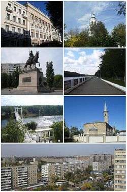 Clockwise from top: City Hall, Nikolsky Orthodox cathedral, Ural River Embankment, Ramazan Mosque, City skyline from Tchkalova street, Pedestrian bridge over Ural River, Monument to Orenburg cossacks | |
.svg.png) Location of Orenburg Oblast in Russia | |
 Orenburg | |
|
| |
 |
|
|
| |
| Administrative status (as of October 2015) | |
| Country | Russia |
| Federal subject | Orenburg Oblast[1] |
| Administratively subordinated to | City of Orenburg[1] |
| Administrative center of | Orenburg Oblast,[1] Orenburgsky District,[2] City of Orenburg[3] |
| Municipal status (as of October 2015) | |
| Urban okrug | Orenburg Urban Okrug[4] |
| Administrative center of | Orenburg Urban Okrug, Orenburgsky Municipal District |
| Head | Yevgeny Arapov[5] |
| Representative body | City Duma |
| Statistics | |
| Area | 259 km2 (100 sq mi)[6] |
| Population (2010 Census) | 548,331 inhabitants[7] |
| - Rank in 2010 | 28th |
| Density | 2,117/km2 (5,480/sq mi)[8] |
| Time zone | YEKT (UTC+05:00)[9] |
| Founded | 1743[10] |
| Postal code(s)[11] | 460000 |
| Dialing code(s) | +7 3532 |
|
| |
| Orenburg on Wikimedia Commons | |
Orenburg (Russian: Оренбург; IPA: [ərʲɪnˈburk]) is the administrative center of Orenburg Oblast (region), Russia, lies on the River Ural, 1,478 kilometers (918 mi) southeast of Moscow. Because of its geographical location (in the boundary of Europe and Asia), Orenburg is very close to the border with Kazakhstan. Population: 548,331 (2010 Census);[7] 549,361 (2002 Census);[12] 546,501 (1989 Census).[13]
Geography

The city is in the basin of the middle current of the River Ural (near its confluence with the River Sakmara). The highest point of the city is 154.4 meters (507 ft).
The origins of the city's name
Several historians have tried to explain the origins of the city's name. It was traditionally accepted that the word "orenburg" means a fortress on the River Or.[14] In all probability, the word combination "orenburg" was proposed by I.K. Kirillov, who was the founder of the city. In 1734, in accordance with his project, a package of governmental documents was worked out. This was the starting point for Orenburg as a fortress city near the place where the Or and the Ural rivers cross.
On 7 June 1734, "A Privilege for Orenburg" (tsar's edict) was ordered by Empress Anna Ivanovna. While a construction site of the main fortress changed many times (down the River Ural), the very name "Orenburg" has not changed since its founding in 1743.
Between 1938 and 1957, the city was referred to as Chkalov,[15][16] named after the famous Soviet pilot Valery Chkalov, although he was not born in and never lived in Orenburg, and never visited Orenburg. In 1954, Chkalov's 5-meter bronze sculpture was erected on the occasion of his 50th birth anniversary; this was installed on a 7-meter pedestal in the Boulevard (on the riverside promenade of the city, commonly named "Belovka").
Orenburg is unofficially called the Asian capital of Russia.[17]
History

In 1734, the Russian Empire began expanding its control and influence in Asia starting from the construction of the fortress city called "Orenburg" on its eastern border (in Southern Ural). For this purpose, a settlement was founded here in 1735 - at the place where the Or and the Ural rivers cross.
The initial site was chosen for settlement during the expedition of I.K. Kirilov, who initiated developmental activities in the region. He argued that the city was necessary "...for opening up transit routes to Bukhara, Badakhshan, Bulk, and to India", making it possible to receive "wealth from there — gold, lapis lazuli, and garnet." After his death, a new administrator of the Orenburg expedition, Vasily Tatishchev, was appointed. He did not considered this place to be convenient for construction of the city, because it was constantly flooded by the spring high waters. This encouraged to launch in 1739 preparations for building a new town with the old name downstream the river Ural (Yaik) on the mountain Krasnaya (Red). The old settlement was named the Orsk fortress (now the city of Orsk).
On 6 August 1741, the new town was founded. However, its construction did not start. The location on the mountain Krasnaya — treeless, rocky and remote from the river — was also inappropriate for building the town. A new administrator of the Orenburg expedition, Ivan Neplyuyev, was appointed.
On 19 (30) April 1743, Orenburg was founded for a third time, on the compound that was once the Berd fortress (town of Berd), 70 versts from the Krasnogorsk mountain area. In the summer of 1742, Neplyuev personally chose a new place surrounded by forests and crop fields, where the Yaik and the Sakmara rivers cross. Now it is the historical center of the city. The city built upon the mountain Krasnaya was named Krasnogorsk.
Orenburg, therefore, was successfully established by Ivan Neplyuyev in its present location approximately 250 kilometers (160 mi) west down the Ural from Orsk in 1743. This third Orenburg has functioned as an important military outpost on the border with the nomadic Kazakhs. It became the center of the Orenburg Cossacks.
Orenburg played a major role in Pugachev's Rebellion (1773–1774). At the time, it was the capital of a vast district and the seat of the governor. Yemelyan Pugachev besieged the city and its fortress from nearby Berda from October 1773 - March 26, 1774. The defense was organized by lieutenant-general Reinsdorp. General Golytsin defeated Pugachev at Berda, and later again at Kargala (north of Orenburg). Most of the city was left in ruins, and thousands of inhabitants had died in the siege.
Alexander Pushkin visited Orenburg in 1833 during a research trip for his books The History of Pugachev and his famous novel The Captain's Daughter. He met his friend Vladimir Dal here, who would later write the first serious dictionary of the Russian language.
Orenburg was the base for General Perovsky's expeditions against the Khanate of Khiva in the 1830s through 1850s. After the incorporation of Central Asia into the Russian Empire, Orenburg became a trading station and, since the completion of the Trans-Aral Railway, a prominent railway junction en route to the new Central Asian possessions and to Siberia.
Orenburg functioned as the capital of the Kirghiz Autonomous Soviet Socialist Republic (in present-day Kazakhstan) within Russia from 1920–1925. When that republic was renamed Kazak Autonomous Soviet Socialist Republic in 1925, Orenburg joined Russia and Kyzylorda became the new capital. Almaty became the capital in 1929 after the construction of the Turkestan–Siberia Railway. Kazak Autonomous Soviet Socialist Republic was promoted to the union republic status as the Kazakh Soviet Socialist Republic Kazakh SSR in 1936. Orenburg remained in Russia.
From 1938 to 1957, the city bore the name Chkalov (Чка́лов) (after the prominent test pilot Valery Chkalov). The city's distance from the German invasion during World War II led many Soviet enterprises to flee there, helping to spur the city's economic growth.
Administrative and municipal status
Orenburg is the administrative center of the oblast[1] and, within the framework of administrative divisions, it also serves as the administrative center of Orenburgsky District,[2] even though it is not a part of it.[3] As an administrative division, it is, together with ten rural localities, incorporated separately as the City of Orenburg[1]—an administrative unit with the status equal to that of the districts. As a municipal division, the City of Orenburg is incorporated as Orenburg Urban Okrug.[4]
Economy
Orenburg is a home for several large companies or their subsidiaries: Orenburggazprom,[18] the subsidiary of Gazprom; Orenburgneft,[19] the subsidiary of TNK-BP oil company; Orenburgenergy, one of the biggest energy generating companies in Russia.
Transportation
.jpg)
Orenburg has been a major railway center ever since the Samara-Zlatoust and Orenburg-Tashkent railroads were completed, respectively in 1876 and 1905.[20]
Orenburg's main airport is the Orenburg Tsentralny Airport,[21] located about 25 kilometers (16 mi) east of the city, on the Orsk destination, and is the headquarters of Orenair.[21]
City public transport included bus, trolleybus and also marshrutkas (fixed-route cabs).
Military
There is an airbase located 9 kilometers (5.6 mi) southwest of the city.
Climate
Orenburg has a relatively dry humid continental climate (Köppen climate classification Dfa) with quite long and hot summers with long and cold winters. April and October are transition months, with the rest of the months being either summer or winter.
| Climate data for Orenburg | |||||||||||||
|---|---|---|---|---|---|---|---|---|---|---|---|---|---|
| Month | Jan | Feb | Mar | Apr | May | Jun | Jul | Aug | Sep | Oct | Nov | Dec | Year |
| Record high °C (°F) | 4.7 (40.5) |
5.8 (42.4) |
18.9 (66) |
31.3 (88.3) |
36.5 (97.7) |
39.8 (103.6) |
41.6 (106.9) |
40.9 (105.6) |
38.0 (100.4) |
27.0 (80.6) |
19.2 (66.6) |
8.1 (46.6) |
41.6 (106.9) |
| Average high °C (°F) | −8 (18) |
−7.2 (19) |
−0.8 (30.6) |
12.8 (55) |
22.1 (71.8) |
27.5 (81.5) |
29.0 (84.2) |
27.4 (81.3) |
20.9 (69.6) |
11.2 (52.2) |
0.3 (32.5) |
−5.9 (21.4) |
10.8 (51.4) |
| Daily mean °C (°F) | −11.8 (10.8) |
−11.5 (11.3) |
−5.2 (22.6) |
6.9 (44.4) |
15.2 (59.4) |
20.6 (69.1) |
22.3 (72.1) |
20.3 (68.5) |
14.0 (57.2) |
5.9 (42.6) |
−3.2 (26.2) |
−9.5 (14.9) |
5.3 (41.5) |
| Average low °C (°F) | −15.6 (3.9) |
−15.7 (3.7) |
−9.3 (15.3) |
1.7 (35.1) |
8.5 (47.3) |
13.8 (56.8) |
15.6 (60.1) |
13.6 (56.5) |
7.9 (46.2) |
1.6 (34.9) |
−6.1 (21) |
−13.1 (8.4) |
0.2 (32.4) |
| Record low °C (°F) | −43.2 (−45.8) |
−40.1 (−40.2) |
−36.8 (−34.2) |
−26 (−15) |
−5.7 (21.7) |
−0.7 (30.7) |
4.9 (40.8) |
−0.9 (30.4) |
−5.3 (22.5) |
−19.8 (−3.6) |
−35.7 (−32.3) |
−39.2 (−38.6) |
−43.2 (−45.8) |
| Average precipitation mm (inches) | 29 (1.14) |
22 (0.87) |
25 (0.98) |
28 (1.1) |
30 (1.18) |
36 (1.42) |
41 (1.61) |
29 (1.14) |
27 (1.06) |
34 (1.34) |
33 (1.3) |
31 (1.22) |
365 (14.37) |
| Average rainy days | 4 | 3 | 6 | 11 | 15 | 15 | 14 | 13 | 13 | 14 | 11 | 6 | 125 |
| Average snowy days | 23 | 20 | 13 | 4 | 0.2 | 0 | 0 | 0 | 0.3 | 4 | 15 | 21 | 101 |
| Average relative humidity (%) | 80 | 78 | 79 | 65 | 53 | 55 | 57 | 57 | 60 | 70 | 81 | 81 | 68 |
| Mean monthly sunshine hours | 76 | 118 | 158 | 224 | 307 | 307 | 330 | 286 | 212 | 126 | 63 | 62 | 2,269 |
| Source #1: Pogoda.ru.net[22] | |||||||||||||
| Source #2: NOAA (sun 1961–1990)[23] | |||||||||||||
Education and culture
Orenburg is a regional center of education and has a number of cultural institutions and museums.
Education
- Orenburg State University
- Orenburg State Medical Academy. Established in 1944 as Chkalov State Medical Institute. It was renamed to Orenburg State Medical Institute in 1957 (at that time Orenburg city regained its original name after being named Chkalov from 1937 till 1957). Gained status of academy in 1994. Currently there are 8 Faculties: Medicine, Pediatric, Stomatology (Dentistry), Pharmacy, Clinical Psychology, Nursing, Public Health (Медико-профилактический), Continuing Education.
- Orenburg State Agrarian University. Established in 1930 as Orenburg Agricultural Institute. It was transformed to Orenburg State Agricultural Academy in 1992. Since 1995 named as Orenburg State Agrarian University. There are 8 Faculties and 4 Institutes.
- Orenburg State Pedagogical University. Established in 1919 as Institute of Public Education. Renamed to Pedagogical Institute in 1930. Transformed to Pedagogical University in 1996. There are 10 Faculties and 4 Research Institutes.
- Orenburg Branch of Kutafin Moscow State Law University
- Orenburg Branch of Gubkin Russian State University of Oil and Gas
Museums
- Orenburg Regional Museum of History and Natural Science
- Orenburg Regional Museum of Art
- Museum of Orenburg History
- Memorial Apartment of Yuri and Valentina Gagarin
- Memorial Apartment of Leopold and Mstislav Rostropovich
- Memorial Apartment of T.G. Shevchenko
- Orenburg City Memorial House
Theaters
- Orenburg Maxim Gorky State Drama Theater
- Orenburg State Regional Music Theater [24]
- Orenburg State Tatar Drama Theater
- Orenburg State Regional Puppet Theater
- Orenburg Municipal Puppet Theater "Pierrot
- Orenburg Municipal Chamber Choir
- Orenburg State Academic Russian Folk Choir
Tourism
Mountain and river tourism are developed in the region. There are a number of fast mountain rivers and rocks in pleated spurs of the southern edge of the Urals range, popular with tourists.
The city is famous for its down Orenburg shawls. The thinnest lacy design, knitted by hand shawls and cobweb-like kerchiefs (pautinkas), is not only warm, but also is used for decorative purposes.
Architecture
- See also Arkhitektura
A famous boulevard on the embankment of the Ural River is one of the most notable places in Orenburg.
Orenburg TV Tower is a guyed mast of unusual design. It is a 200-meter (660 ft) tall mast equipped with six crossbars running from the mast structure to the guys.[25]
Sports
- FC Orenburg, the local football team founded in 1970, reached the Russian Premier League for the first time during the 2016-17 season
- Lokomotiv[26] has played in the highest division of the Russian Bandy League. Now they play in the second highest division. Their home arena has a capacity of 5000.[27]
- Nadezhda Orenburg is a women's basketball club competing in the Russian Women's Basketball Premier League and playing in the Orenburzhe Sports Hall.
- Fakel Gazproma[28] is a table tennis club with, among other players, the three time European champion Uładzimir Samsonaŭ.
National events
In October 2015, the Russian Rink Bandy Cup will be organised.
Honors
The asteroid 27709 Orenburg was named after the city on June 1, 2007.†
Notable people
- Ivan Krylov (1769–1844), writer
- Vasily Alekseevich Perovsky (1794—1857), statesman
- Vladimir Dal (1801–1872), lexicographer
- Yevgraf Fyodorov (1853–1919), mathematician, crystallographer, and mineralogist
- Paul Nazaroff (1890–1942), geologist and writer
- Joseph Kessel (1898–1979), journalist and novelist
- Musa Cälil (1906–1944), poet
- Alexander Schmorell (1917–1943), a member of the anti-Nazi group White Rose
- Aleksander Burba (1918-1984), industry leader and educator
- Mstislav Rostropovich (1927–2007), cellist
- Yuri Gagarin (1934–1968), cosmonaut
- Denis Istomin (born 1986), tennis player
- Georgy Malenkov (1902-1988) communist party leader
International relations
Orenburg has the following sister cities:[29]
 Khujand, Tajikistan
 Legnica, Poland
 Orlando, United States
 Ufa, Russia
 Oral, Kazakhstan
References
Notes
- 1 2 3 4 5 6 Law #1370/276-IV-OZ
- 1 2 Государственный комитет Российской Федерации по статистике. Комитет Российской Федерации по стандартизации, метрологии и сертификации. №ОК 019-95 1 января 1997 г. «Общероссийский классификатор объектов административно-территориального деления. Код 53 234», в ред. изменения №259/2014 от 12 декабря 2014 г.. (State Statistics Committee of the Russian Federation. Committee of the Russian Federation on Standardization, Metrology, and Certification. #OK 019-95 January 1, 1997 Russian Classification of Objects of Administrative Division . Code 53 234, as amended by the Amendment #259/2014 of December 12, 2014. ).
- 1 2 Государственный комитет Российской Федерации по статистике. Комитет Российской Федерации по стандартизации, метрологии и сертификации. №ОК 019-95 1 января 1997 г. «Общероссийский классификатор объектов административно-территориального деления. Код 53 401», в ред. изменения №259/2014 от 12 декабря 2014 г.. (State Statistics Committee of the Russian Federation. Committee of the Russian Federation on Standardization, Metrology, and Certification. #OK 019-95 January 1, 1997 Russian Classification of Objects of Administrative Division . Code 53 401, as amended by the Amendment #259/2014 of December 12, 2014. ).
- 1 2 Law #2367/495-IV-OZ
- ↑ "Глава города Оренбурга". Официальный портал города Оренбурга. Archived from the original on 2012-08-17. Retrieved 2012-06-25.
- ↑ Генеральный план Оренбурга. Материалы по обоснованию проекта. Раздел 4.1. Территория города. Стр. 29
- 1 2 Russian Federal State Statistics Service (2011). "Всероссийская перепись населения 2010 года. Том 1" [2010 All-Russian Population Census, vol. 1]. Всероссийская перепись населения 2010 года (2010 All-Russia Population Census) (in Russian). Federal State Statistics Service. Retrieved June 29, 2012.
- ↑ The value of density was calculated automatically by dividing the 2010 Census population by the area specified in the infobox. Please note that this value may not be accurate as the area specified in the infobox does not necessarily correspond to the area of the entity proper or is reported for the same year as the population.
- ↑ Правительство Российской Федерации. Федеральный закон №107-ФЗ от 3 июня 2011 г. «Об исчислении времени», в ред. Федерального закона №271-ФЗ от 03 июля 2016 г. «О внесении изменений в Федеральный закон "Об исчислении времени"». Вступил в силу по истечении шестидесяти дней после дня официального опубликования (6 августа 2011 г.). Опубликован: "Российская газета", №120, 6 июня 2011 г. (Government of the Russian Federation. Federal Law #107-FZ of June 31, 2011 On Calculating Time, as amended by the Federal Law #271-FZ of July 03, 2016 On Amending Federal Law "On Calculating Time". Effective as of after sixty days following the day of the official publication.).
- ↑ Из истории Казахстана XVIII в
- ↑ Почта России. Информационно-вычислительный центр ОАСУ РПО. (Russian Post). Поиск объектов почтовой связи (Postal Objects Search) (Russian)
- ↑ Russian Federal State Statistics Service (May 21, 2004). "Численность населения России, субъектов Российской Федерации в составе федеральных округов, районов, городских поселений, сельских населённых пунктов – районных центров и сельских населённых пунктов с населением 3 тысячи и более человек" [Population of Russia, Its Federal Districts, Federal Subjects, Districts, Urban Localities, Rural Localities—Administrative Centers, and Rural Localities with Population of Over 3,000] (XLS). Всероссийская перепись населения 2002 года [All-Russia Population Census of 2002] (in Russian). Retrieved August 9, 2014.
- ↑ Demoscope Weekly (1989). "Всесоюзная перепись населения 1989 г. Численность наличного населения союзных и автономных республик, автономных областей и округов, краёв, областей, районов, городских поселений и сёл-райцентров" [All Union Population Census of 1989: Present Population of Union and Autonomous Republics, Autonomous Oblasts and Okrugs, Krais, Oblasts, Districts, Urban Settlements, and Villages Serving as District Administrative Centers]. Всесоюзная перепись населения 1989 года [All-Union Population Census of 1989] (in Russian). Институт демографии Национального исследовательского университета: Высшая школа экономики [Institute of Demography at the National Research University: Higher School of Economics]. Retrieved August 9, 2014.
- ↑ Поспелов Е.М. Географические названия мира: топонимический словарь. — М.: Русские словари; Астрель; ACT, 2002. — ISBN 5-17-002938-1 ; 5-271-00446-5 ; 5-93259-014-9 ; 5-17-001389-2.
- ↑ Оренбург — статья из Большой советской энциклопедии.
- ↑ Город был переименован Указом ПрезидиумаПрезидиума Верховного Совета СССР от 26 декабря 1938 г.
- ↑ Глущенко Е. А. Россия в Средней Азии. Завоевания и преобразования. М.: Центрполиграф, 2010. 575 с. (Россия забытая и неизвестная. Золотая коллекция). С.62. ISBN 978-5-227-02167-0.
- ↑ http://www.gazprom.com/eng/articles/article28937.shtml
- ↑ http://www.tnk-bp.com/operations/enterprises/orenburgneft/
- ↑ Correspondence, Foreign (November 7, 1904). "RUSSIA'S NEW GREAT RAILROAD IN ASIA; Orenburg-Tashkent Line Was Completed a Few Days Ago. GREAT VALUE STRATEGICALLY Prince Hilkoff Pushed the Construction of the Road with Much Energy -- The Cities Traversed". The New York Times.
- 1 2 http://www.airoport.orenair.ru/index.php?eng=1
- ↑ "КЛИМАТ ОРЕНБУРГА" (in Russian). Погода и климат. Retrieved April 4, 2016.
- ↑ "Orenburg Climate Normals 1961–1990". National Oceanic and Atmospheric Administration. Retrieved April 4, 2016.
- ↑ http://www.orenburg.ru/culture/theatre/
- ↑ http://vcfm.ru/vc/Cities/orenburg.htm
- ↑
- ↑
- ↑ fakelgazproma.ru/
- ↑ profile documents, Orenburg
Sources
- Законодательное Собрание Оренбургской области. Закон №1370/276-IV-ОЗ от 11 июля 2007 г. «Об административно-территориальном устройстве Оренбургской области», в ред. Закона №2826/783-V-ОЗ от 15 декабря 2014 г. «О внесении изменений в Закон Оренбургской области "Об административно-территориальном устройстве Оренбургской области"». Вступил в силу после официального опубликования. Опубликован: "Южный Урал", №№134–135 (спецвыпуск №40 с документами Законодательного Собрания Оренбургской области), 21 июля 2007 г. (Legislative Assembly of Orenburg Oblast. Law #1370/276-IV-OZ of July 11, 2007 On the Administrative-Territorial Structure of Orenburg Oblast, as amended by the Law #2826/783-V-OZ of December 15, 2014 On Amending the Law of Orenburg Oblast "On the Administrative-Territorial Structure of Orenburg Oblast". Effective as of after the official publication date.).
- Законодательное Собрание Оренбургской области. Закон №2367/495-IV-ОЗ от 15 сентября 2008 г. «Об утверждении перечня муниципальных образований Оренбургской области и населённых пунктов, входящих в их состав», в ред. Закона №3322/917-V-ОЗ от 24 августа 2015 г. «О внесении изменений в Закон Оренбургской области "Об утверждении перечня муниципальных образований Оренбургской области и населённых пунктов, входящих в их состав"». Вступил в силу через 10 дней после официального опубликования. Опубликован: "Бюллетень Законодательного Собрания Оренбургской области", 22 заседание, I часть, 29 августа 2008 г. (Legislative Assembly of Orenburg Oblast. Law #2367/495-IV-OZ of September 15, 2008 On Adopting the Registry of the Municipal Formations of Orenburg Oblast and the Inhabited Localities They Comprise, as amended by the Law #3322/917-V-OZ of August 24, 2015 On Amending the Law of Orenburg Oblast "On Adopting the Registry of the Municipal Formations of Orenburg Oblast and the Inhabited Localities They Comprise". Effective as of after 10 days following the official publication.).
External links
- Official website of Orenburg (Russian)
- Orenburg State Institute of Management
- Photos of Orenburg (Russian)
| Cities and towns (all levels) | |||
|---|---|---|---|
| Closed administrative-territorial formations | |||
| Districts |
| ||