Ortaköy
Ortaköy (literally Middle Village in Turkish; in Greek was known as Agios Focàs, in Byzantine period and Mesachori later, meaning "middle village") is a neighbourhood, formerly a small village, within the Beşiktaş district of Istanbul, Turkey, located in the middle of the European bank of the Bosphorus.
Ortaköy was a cosmopolitan area during the Ottoman era and the first decades of the Turkish Republic, with communities of Turks, Greeks, Armenians and Jews. Today the neighbourhood still hosts many different religious (Muslim, Jewish, Orthodox, and other Christian) structures. It is also a popular spot for locals and tourists alike, with its art galleries, night clubs, cafés, bars, and restaurants.
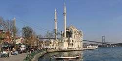
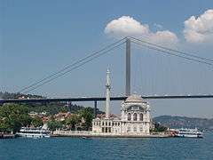
The Neo-Baroque style Ortaköy Mosque is a beautifully ornate structure, right on the jetty of Ortaköy, bordering the waters of the Bosphorus, and thus highly visible from the passing boats.
Several reputable schools, such as Kabataş Erkek Lisesi and Galatasaray University, are located in Ortaköy. The European pylon of the Bosphorus Bridge, one of the two bridges that connect the European and Asian banks of İstanbul, is also situated in this neighbourhood.
Ortaköy was the site of George W. Bush's speech during the NATO Summit of 2004, which he delivered at Galatasaray University.
History
Ortaköy has had an important place in the daily life of the city during both the Byzantine and Ottoman periods. In the 16th century, the Ottoman Sultan Suleiman the Magnificent encouraged the Turks to move to Ortaköy and live there, which marked the beginning of the Turkish presence in the neighbourhood. One of the oldest buildings in Ortaköy is the Turkish Bath built by the famous Ottoman architect Mimar Sinan in 1556.
The famous Ortaköy Mosque, located on the coastal pier square, was originally built in the 18th century. Later, in the 19th century, the current mosque, ordered by Sultan Abdülmecid I and designed by architects (father and son) Garabet Amira Balyan and Nigoğayos Balyan in Neo-Baroque style, was edificed between 1854 and 1856.
In 1871, Sultan Abdülaziz built the Çırağan Palace in Ortaköy, where he lived for some time. Çırağan Palace was also used as the Ottoman Parliament building until it was severely damaged by a fire in 1910. The palace was repaired and restored in the 1980s and is known today as the Çırağan Palace Kempinski Istanbul Hotel, one of the most luxurious hotels in Istanbul.
The famous German architect Bruno Taut lived in a house he designed in Ortaköy. It reflected his life in exile by combining Japanese and European architectural styles.
Ortaköy's once famously cosmopolitan population began to disappear with the emigration of non-Muslim minority groups.
After the establishment of Israel in 1948, the Jewish population rapidly decreased. The riots of 1955 caused the emigration of many members of Istanbul's minority groups, including Ortaköy's Greeks and Armenians. There are very few non-Muslims left today.
Sports
The sporting club of the neighbourhood is Ortaköy Spor Kulübü.
Entertainment
Apart from beautiful cafés with a Bosphorus view, such as the Ortaköy Kahvesi,[2] pubs and restaurants near the ferry port, Ortaköy also has some of Istanbul's best seashore night clubs, including Reina,[3] Sortie[4] and Anjelique.[5]
See also
References and notes
External links
![]() Media related to Ortaköy at Wikimedia Commons
Media related to Ortaköy at Wikimedia Commons
Coordinates: 41°02′53″N 29°01′25″E / 41.04806°N 29.02361°E