Overhalla
| Overhalla kommune | |||
|---|---|---|---|
| Municipality | |||
 | |||
| |||
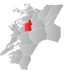 Overhalla within Nord-Trøndelag | |||
| Coordinates: 64°30′28″N 11°53′38″E / 64.50778°N 11.89389°ECoordinates: 64°30′28″N 11°53′38″E / 64.50778°N 11.89389°E | |||
| Country | Norway | ||
| County | Nord-Trøndelag | ||
| District | Namdalen | ||
| Administrative centre | Ranemsletta | ||
| Government | |||
| • Mayor (2011) | Per Olav Tyldum [1] (Sp) | ||
| Area | |||
| • Total | 729.79 km2 (281.77 sq mi) | ||
| • Land | 688.79 km2 (265.94 sq mi) | ||
| • Water | 41.00 km2 (15.83 sq mi) | ||
| Area rank | 149 in Norway | ||
| Population (2011) | |||
| • Total | 3,636 | ||
| • Rank | 243 in Norway | ||
| • Density | 5.3/km2 (14/sq mi) | ||
| • Change (10 years) | 0.3 % | ||
| Demonym(s) | Overhallning[2] | ||
| Time zone | CET (UTC+1) | ||
| • Summer (DST) | CEST (UTC+2) | ||
| ISO 3166 code | NO-1744 | ||
| Official language form | Neutral | ||
| Website |
www | ||
|
| |||

Overhalla is a municipality in Nord-Trøndelag county, Norway. It is part of the Namdalen region. The administrative centre of the municipality is the village of Ranemsletta (also called Overhalla). Other villages include Melen, Skage, Skogmo, Svalia, and Øysletta.
The population is concentrated in the relatively broad Namsen river valley at the center. Public services, agriculture, and tourism are the main sources of income. Overhallahus (a house building company) and Pharmaq (a fish vaccine factory) are located in the municipality.
General information
The municipality of Overhalla was established on 1 January 1838 (see formannskapsdistrikt). On 1 January 1964, the Galguften and Hauknes area (population: 15) of Høylandet was transferred to Overhalla.[3]
Name
The Old Norse form of the name was œfri halfa which means "the upper half (of Namdalen)". Historically, the Namdalen district was divided in two parts: "the upper half" and "the lower half". The municipality of Overhalla today is, however, just a fraction of the old part of œfri halfa.[4][5]
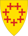
Coat-of-arms
The coat-of-arms is from 1989, but is inspired by an old seal for the district by King Håkon Magnusson from 1344. It shows seven red greek crosses arranged in a circle on a gold background.[5]
Churches
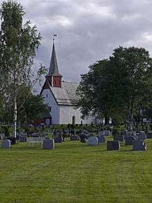
The Church of Norway has two parishes (sokn) within the municipality of Overhalla. It is part of the Namdal deanery in the Diocese of Nidaros.
| Parish (Sokn) | Church Name | Location of the Church | Year Built |
|---|---|---|---|
| Ranem | Ranem Church | Ranemsletta | 1187 |
| Skage | Skage Church | Skage | 1903 |
Geography

The municipality includes part of the lake Eidsvatnet, from which the river Bjøra flows into the river Namsen, which runs from the east to the west. By the time it reaches the border to Namsos, Namsen is already brackish and influenced by the tides the ocean. The river Nordelva also empties into the estuary here. On the south side of Namsen, there is an area of mountains, including Reinsjøfjell and mountain lakes; the Bangsjøene lakes form the border with Snåsa. The western approaches to Geitfjell lies in Overhalla, while the summit lies in Grong. The southern tip of the lake Storgrønningen lies in Overhalla, while the vast majority of the lake lies in Høylandet.
Government
All municipalities in Norway, including Overhalla, are responsible for primary education (through 10th grade), outpatient health services, senior citizen services, unemployment and other social services, zoning, economic development, and municipal roads. The municipality is governed by a municipal council of elected representatives, which in turn elect a mayor.
Municipal council
The municipal council (Kommunestyre) of Overhalla is made up of 21 representatives that are elected to every four years. Currently, the party breakdown is as follows:[6]
| Party Name | Name in Norwegian | Number of representatives | |
|---|---|---|---|
| Labour Party | Arbeiderpartiet | 5 | |
| Progress Party | Fremskrittspartiet | 2 | |
| Conservative Party | Høyre | 1 | |
| Centre Party | Senterpartiet | 13 | |
| Total number of members: | 21 | ||
Transportation
The historic Namsos Line railway traversed the municipality on its way from Grong to Namsos, but the line was closed to passenger traffic in 1978. Freight traffic on the line was discontinued in 2002. The Norwegian County Road 17 also crosses the municipality.
Notable residents
- Hans Andersen Barlien (1772–1842), Norwegian politician, credited with the establishment of a Norwegian-American immigrant settlement in Sugar Creek, Iowa
- Bjarne Brøndbo (born 1964) and Eskil Brøndbo (born 1970) rock musicians
- Gunhild Følstad (born 1981) international women's footballer
- Alf Hildrum (born 1948), media executive and politician
- Johannes Rian (1891–1981), painter
References
- ↑ "Ordføreren i Overhalla" (in Norwegian). Overhalla kommune. Retrieved 2014-08-20.
- ↑ "Navn på steder og personer: Innbyggjarnamn" (in Norwegian). Språkrådet. Retrieved 2015-12-01.
- ↑ Jukvam, Dag (1999). "Historisk oversikt over endringer i kommune- og fylkesinndelingen" (PDF) (in Norwegian). Statistisk sentralbyrå.
- ↑ Rygh, Oluf (1903). Norske gaardnavne: Nordre Trondhjems amt (dokpro.uio.no) (in Norwegian) (15 ed.). Kristiania, Norge: W. C. Fabritius & sønners bogtrikkeri. p. 306.
- 1 2 "Fakta om Overhalla" (in Norwegian). Overhalla kommune. Retrieved 2008-11-13.
- ↑ "Table: 04813: Members of the local councils, by party/electoral list at the Municipal Council election (M)" (in Norwegian). Statistics Norway. 2015.
External links
| Wikimedia Commons has media related to Overhalla. |
 Nord-Trøndelag travel guide from Wikivoyage
- Municipal fact sheet from Statistics Norway