Owenbrean River
| Owenbrean (Abhainn Bhréan) | |
| River | |
| Country | United Kingdom |
|---|---|
| Region | Northern Ireland |
| County | Co. Fermanagh |
| Landmarks | Pollasumera, Pollnagollum of the Boats |
| Source | |
| - location | Eastern Cuilcagh Mountain |
| Mouth | River Cladagh |
| - location | Marble Arch Caves |
| Length | 8.5 km (5 mi) |
The Owenbrean River (Irish: Abhainn Bhréan or "stinking river"[1]), is a small river in County Fermanagh, Northern Ireland which flows down from Cuilcagh Mountain before sinking underground, eventually reaching the Marble Arch Cave system. The river meets up with two other mountain rivers within the caves, the Sruh Croppa and the Aghinrawn; these three rivers then form the River Cladagh.
Main route
The Owenbrean drains the north-eastern slopes of Cuilcagh Mountain and the southern and western slopes of Trien Mountain. After meandering northwards for 5 km (3.1 mi), it turns abruptly west into a confined, blind gorge for 300 m (980 ft) before swinging north into the magnificent gothic entrance of Pollasumera, set in 20 m (66 ft) high cliffs.[2] In dry weather, the river drains into its bed in the gorge before reaching the cave.[3]
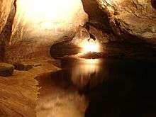
The Owenbrean flows underground through Pollasumera, until it sumps and appears again in nearby Pollnagollum of the Boats. The river eventually enters the Marble Arch system via Skreen Hill 3—a 650-metre (2,130 ft) long stretch of cave only accessible by divers—Skreen Hill 2 and Skreen Hill 1, which is the furthest section of the show cave.[4] During the guided tour of the Marble Arch Caves, visitors are led on a subterranean pathway alongside the Owenbrean River, as well as travelling upon it for a short while on an underground boat journey. The Owenbrean meets the combined Sruh Croppa and Aghinrawn at The Junction, which is halfway along the boat tour.[4]
Separation
Upstream of the main sinks in the blind gorge, the Owenbrean is also known to lose a portion of its flow as it is diverted into the Upper and Lower Sinks.[5] These feed into the Prod's Pot–Cascades Rising cave system, from which the waters emerge above ground again around 2.5 km (1.6 mi) away in Cladagh Glen, rejoining the Owenbrean's original flow in its new form as the River Cladagh (Dunn, J.).[5]
Note on naming
The Marble Arch system is fed by three small rivers that drain the north face of Cuilcagh Mountain. East to west these are the Owenbrean, the Aghinrawn and the Sruh Croppa. The Ordnance Survey of Northern Ireland (OSNI) maps have the middle and eastern rivers wrongly marked. Locally the central river flowing to Monastir Cliff (the Owenbrean on OSNI maps) has always been called the Aghinrawn and the eastern river, sinking at Pollasumera (unnamed on the OSNI maps) is the Owenbrean. All other literature adheres to this local usage.[4][6]
See also
Notes
- ↑ "Illustrations of Townlands in Maps". Ulster Placenames – Celebrating Ulster's Townlands. Retrieved 28 February 2009.
- ↑ Jones, Burns, Fogg & Kelly (1997), p. 92
- ↑ "Marble Arch Karst; Pollasumera". Habitas Online. Retrieved 28 February 2009.
- 1 2 3 Jones, Burns, Fogg & Kelly (1997), pp. 79–84
- 1 2 Jones, Burns, Fogg & Kelly (1997), pp. 60–61
- ↑ "Marlbank-Cuilcagh Mountain Region; Marble Arch Karst". Habitas Online. Retrieved 28 February 2009.
References
- Jones, Gareth Ll.; Burns, Gaby; Fogg, Tim; Kelly, John (1997). The Caves of Fermanagh and Cavan (2nd Ed.). Lough Nilly Press. ISBN 0-9531602-0-3.
Coordinates: 54°14′48″N 7°47′49″W / 54.24667°N 7.79686°W