Paavola
| Paavola | ||
|---|---|---|
| Former municipality | ||
| Paavolan kunta | ||
|
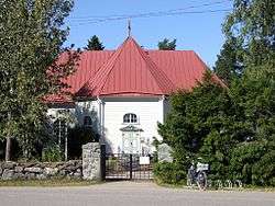
Paavola Church | ||
| ||
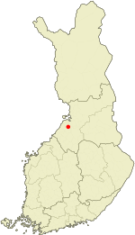 Location of Paavola in Finland | ||
| Coordinates: 64°36′30″N 025°12′20″E / 64.60833°N 25.20556°ECoordinates: 64°36′30″N 025°12′20″E / 64.60833°N 25.20556°E | ||
| Country | Finland | |
| Region | Northern Ostrobothnia | |
| Established | 1874 | |
| Consolidated | 1973 | |
| Area[1] | ||
| • Land | 565.8 km2 (218.5 sq mi) | |
| Population (1970)[1] | ||
| • Total | 4,568 | |
| • Density | 8.07/km2 (20.9/sq mi) | |
| Time zone | EET (UTC+2) | |
| • Summer (DST) | EEST (UTC+3) | |

Paavola is a former municipality of Finland, now a village in the municipality of Siikajoki. The village is located beside the Siikajoki river. Though lacking rail transport connections, the settlement does lie beside the crossroads of routes 86 and 807.
In 1973, Paavola was consolidated with the neighboring municipality of Revonlahti to form the municipality of Ruukki. Ruukki in turn was consolidated with Siikajoki in 2007.
Picture Gallery
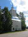 Paavola Church Campanile
References
- 1 2 "Suomen kunnat: Paavola" (in Finnish). Retrieved 1 April 2010.
External links
![]() Media related to Paavola at Wikimedia Commons
Media related to Paavola at Wikimedia Commons
| Municipalities |  | |
|---|---|---|
| Former | ||
This article is issued from Wikipedia - version of the 3/8/2013. The text is available under the Creative Commons Attribution/Share Alike but additional terms may apply for the media files.