Paccharaju
| Paccharaju | |
|---|---|
| Rocotuyo - Rayococha | |
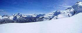 Paccharaju (center) as seen from the south | |
| Highest point | |
| Elevation | 5,749 m (18,862 ft) |
| Coordinates | 9°16′33″S 77°25′57″W / 9.27583°S 77.43250°WCoordinates: 9°16′33″S 77°25′57″W / 9.27583°S 77.43250°W |
| Geography | |
 Paccharaju Peru | |
| Location | Ancash, Peru |
| Parent range | Andes, Cordillera Blanca |
Paccharaju[1][2] (possibly from Ancash Quechua paqtsa waterfall, rahu snow mountain,[3][4] "waterfall snow peak") is a mountain of 5,744 m (18,845 ft)[1] (or 5,749 m (18,862 ft))[5] of elevation in the Cordillera Blanca in the Andes of Peru. In other maps it is shown as comprising two peaks: Rocotuyo[5] (possibly from Quechua rukutu, ruqutu a plant (Capsicum pubescens), -yuq a suffix to indicate ownership,[6][7] "the one with the rukutu") of 5,749 m (18,862 ft)[5] and Rayococha[5] (or Bayoraju)[8] of 5,460 m (17,913 ft).[5][8] It is located between the provinces of Asunción Province and Carhuaz, in Ancash; southwest of mount Tarush Kancha, inside Huascarán National Park.
Rocotuyo[5] (also named Paccharuri)[1] is a lake at 9°16′53″S 77°27′12″W / 9.28139°S 77.45333°W south of the mountain.[9][1]
References
- 1 2 3 4 Alpenvereinskarte 0/3b. Cordillera Blanca Süd (Peru). 1:100 000. Oesterreichischer Alpenverein. 2005. ISBN 3-937530-05-3.
- ↑ "Nevado Paccharaju - Peakbagger.com". www.peakbagger.com. Retrieved 2016-06-18.
- ↑ Robert Beér, Armando Muyolemaj, Dr. Hernán S. Aguilarpaj, Vocabulario comparativo, quechua ecuatoriano - quechua ancashino - castellano - English, Brighton 2006
- ↑ babylon.com
- 1 2 3 4 5 6 Peru 1:100 000, Huari (19-i). IGN (Instituto Geográfico Nacional - Perú).
- ↑ Teofilo Laime Ajacopa, Diccionario Bilingüe Iskay simipi yuyayk'ancha, La Paz, 2007 (Quechua-Spanish dictionary)
- ↑ Diccionario Quechua - Español - Quechua, Academía Mayor de la Lengua Quechua, Gobierno Regional Cusco, Cusco 2005 (Quechua-Spanish dictionary) (five-vowel-system)
- 1 2 Díaz, Felipe (2008–2009). Carta Turística. Cordilleras Blanca, Negra, Huayhuash y Callejón de Huaylas.
- ↑ "Quebrada Paccharuri". mincetur. Retrieved April 12, 2015.
External links
| Wikimedia Commons has media related to Cordillera Blanca. |