Palouse River
| Palouse River | |
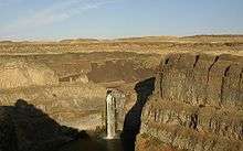
 The Palouse River a few miles downstream from its fork in Colfax, Washington; looking west. | |
| Country | United States |
|---|---|
| States | Washington, Idaho |
| County | Franklin, Whitman, Adams, Latah |
| Source | Rocky Mountains |
| - coordinates | 46°58′07″N 116°27′31″W / 46.9685°N 116.4587°W [1] |
| Mouth | Snake River |
| - elevation | 541 ft (165 m) [1] |
| - coordinates | 46°35′24″N 118°12′55″W / 46.59000°N 118.21528°WCoordinates: 46°35′24″N 118°12′55″W / 46.59000°N 118.21528°W [1] |
| Length | 167 mi (269 km) |
| Basin | 3,303 sq mi (8,555 km2) [2] |
| Discharge | for river mile 19.6 at Hooper |
| - average | 599 cu ft/s (17.0 m3/s) [3] |
| - max | 27,800 cu ft/s (787.2 m3/s) |
| - min | 0 cu ft/s (0.0 m3/s) |
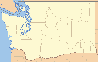 Location of the mouth of the Palouse River in Washington | |
The Palouse River is a tributary of the Snake River located in the U.S. states of Washington and Idaho. It flows for 167 miles (269 km)[4] southwestwards, primarily through the Palouse region of southeastern Washington. It is part of the Columbia River Basin, as the Snake River is a tributary of the Columbia River.
Its canyon was carved out by a fork in the catastrophic Missoula Floods of the previous ice age, which spilled over the northern Columbia Plateau and flowed into the Snake River, eroding the river's present course in a few thousand years.
Course

The Palouse River flows from northern Idaho into southeast Washington through the Palouse region, named for the river.
The river flows through northern Latah County near State Highway 6 as it nears the state line. In Washington, the river flows in Whitman County to Palouse and then to Colfax, where it meets with the south fork, from Pullman and south of Moscow. From Colfax the river meanders west and ends up in the lower Snake River southwest of Hooper, but not before dropping over Palouse Falls. The Palouse River enters the Snake River below the Little Goose Dam and above the Lower Monumental Dam.
Basin and discharge
The Palouse River's drainage basin is 3,303 square miles (8,550 km2) in area.[2] Its mean annual discharge, as measured by USGS gage 13351000 at Hooper (river mile 19.6), is 599 cubic feet per second (17 m3/s), with a maximum daily recorded flow of 27,800 cu ft/s (787 m3/s), and a minimum of zero flow.[3]
Geology
The Missoula Floods that swept periodically across eastern Washington and across the Columbia River Plateau during the Pleistocene epoch carved out the Palouse River Canyon, which is 1,000 feet (300 m) deep in places.[5][6][7]
The ancestral Palouse River flowed through the now-dry Washtucna Coulee directly into the Columbia River. The present-day canyon was created when the Missoula Floods overtopped the northern drainage divide of the ancestral Palouse River, diverting it to the current course to the Snake River by eroding a new, deeper channel.[5][8]
The area is characterized by interconnected and hanging flood-created coulees, cataracts, plunge pools, kolk created potholes, rock benches, buttes and pinnacles typical of scablands.[7]
See also
- Palouse Falls
- Palouse Falls State Park
- List of rivers of Idaho
- List of longest streams of Idaho
- List of rivers of Washington
- Tributaries of the Columbia River
References
- 1 2 3 "Palouse River". Geographic Names Information System. United States Geological Survey. 10 September 1979. Retrieved 2010-06-30.
- 1 2 Palouse Subbasin Plan, Northwest Power and Conservation Council
- 1 2 "Water Resources Data, Water Year 2005; Snake River Basin including the Grande Ronde River, Asotin Creek, Tucannon River, and Palouse River Basins; 13351000 Palouse River at Hooper, WA" (PDF). United States Geological Survey. Retrieved 2009-06-02.
- ↑ U.S. Geological Survey. National Hydrography Dataset high-resolution flowline data. The National Map, accessed May 3, 2011
- 1 2 Carson, Robert J.; Pogue, Kevin R. (1996). Flood Basalts and Glacier Floods:Roadside Geology of Parts of Walla Walla, Franklin, and Columbia Counties, Washington. Washington State Department of Natural Resources (Washington Division of Geology and Earth Resources Information Circular 90). ISBN none.
- ↑ Alt, David. Glacial Lake Missoula & its Humongous Floods. Mountain Press Publishing Company. ISBN 0-87842-415-6.
- 1 2 Bjornstad, Bruce (2006). On the Trail of the Ice Age Floods: A Geological Guide to the Mid-Columbia Basin. Keokee Books; Sandpoint, Idaho. ISBN 978-1-879628-27-4.
- ↑ Alt, David & Hyndman, Donald (1984). Roadside Geology of Washington. Mountain Press Publishing Company. ISBN 0-87842-160-2.
External links
- U.S. Geological Survey Geographic Names Information System: North Fork Palouse River
- U.S. Geological Survey Geographic Names Information System: South Fork Palouse River
- Palouse River Fishing
- Palouse Falls
- Soil Erosion in Palouse River Watershed