Pamlico Sound
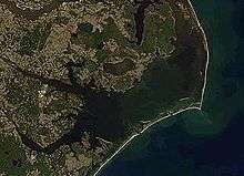
Pamlico Sound (/ˈpæmlᵻkoʊ/ PAM-lik-oh) in North Carolina in the US is the largest lagoon along the North American East Coast, extending 129 km (80 mi) long and 24 to 48 km (15 to 20 miles) wide. It is part of a large, interconnected network of lagoon estuaries that includes Albemarle Sound, Currituck Sound, Croatan Sound, Pamlico Sound, Bogue Sound, Core Sound, and Roanoke Sound.[1][2] Together, these sounds, known as the Albemarle-Pamlico sound system, comprise the second largest estuary in the United States, covering over 3,000 sq. mi. of open water.[3](Chesapeake Bay is the largest.) The Pamlico Sound is separated from the Atlantic Ocean by the Outer Banks, a row of low, sandy barrier islands that include Cape Hatteras National Seashore, Cape Lookout National Seashore, and Pea Island National Wildlife Refuge. The Albemarle-Pamlico Sound is one of nineteen great waters recognized by the America's Great Waters Coalition.[4]
Hydrology
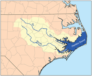
Pamlico Sound is connected to the north with Albemarle Sound through passages provided by the Roanoke Sound and Croatan Sound. Core Sound is located at the Pamlico's narrow southern end.[1][2] It is fed by the Neuse and Pamlico rivers (the latter of which is the estuary of the Tar River) from the west and by Oregon Inlet, Hatteras Inlet, and Ocracoke Inlet, which also provide passage to the Atlantic Ocean.[5] The salinity of the sound averages 20 ppt, compared to an average coastal salinity of 35 ppt in the Atlantic and 3 ppt in the Currituck Sound, which is located north of the Albemarle Sound.[6]
The sound and its ocean inlets are noted for wide expanses of shallow water and occasional shoaling, making the area hazardous for larger vessels. While the deepest hole of the estuary (26') can be found in the Pamlico Sound,[7] depths generally range from 5 to 6 feet.[8] In addition, the shallow waters are susceptible to wind and barometric pressure-driven tidal fluctuations. This effect is amplified on the tributary rivers, where water levels can change by as much as two feet in three hours when winds are aligned with the rivers' axes and are blowing strongly.[1][2]
History and current use
In March 1524, Italian Explorer Giovanni da Verrazzano mistook the sound for the Pacific Ocean because of its wide expanse and separation from the Atlantic Ocean by the Outer Banks barrier islands.[5] The sound was named for the Pamlico Native American tribe that lived along the sound's mainland banks and who were referred to as the Pamouik by the Raleigh expeditions (circa 1584).[9] In 1987, Congress declared the Albemarle-Pamlico Sound an "estuary of national significance."[3]
For vacationers to the Outer Banks, the Pamlico Sound is a "watersports playground" providing opportunities for fishing and crabbing, boating, kayaking, sailing, windsurfing, kiteboarding, parasailing, paddleboarding, and more.[5] In 2012, the economic impact of tourism to the Albemarle-Pamlico Sound system exceeded $1.3 billion.[3]
The sound also supports local commercial fishing, crabbing, shrimping, clamming, and oystering. 90% of North Carolina's commercial fishing catches are attributed to the Pamlico Sound, generating almost $100 million per year.[10]
Wildlife
Along the coastal areas are numerous waterfowl nesting sites, including Pea Island National Wildlife Refuge on the Outer Banks, and Swanquarter National Wildlife Refuge on the mainland.[1][2] Dolphins and sea turtles[11] are abundant,[12] with occasional visits by seals such as harp seal in early January and February. Many other cetaceans including rare species such as fin whales, Cuvier's beaked whales, and orcas are present off Outer Banks and Cape Hatteras. Whales such as Atlantic gray (now extirpated),[13] North Atlantic right (critically endangerend), and North Atlantic humpback were historically common. Endangered species such as leatherback turtles,[14] great white sharks, and basking sharks are also known to visit the sound as well.[6]
The sound also sports a variety of fish populations including red drum, speckled trout, flounder, striped bass (known as rockfish by local populations), croaker, spot, pompano, kingfish, and bluefish. In addition, shellfish populations including blue crab, shrimp, oysters, and clams are healthy.[7]
Gallery
-

A sunset on Pamlico Sound as seen from The Inn on Pamlico Sound in Buxton, North Carolina.
-

Sunset over the Sound just south of Salvo, North Carolina.
References
- 1 2 3 4 "Albemarle-Pamlico Sound". University of Rhode Island.
- 1 2 3 4 "Pamlico Sound". Outer Banks.
- 1 2 3 "NCDEQ - Fast Facts". portal.ncdenr.org. Retrieved 2015-09-29.
- ↑ National Wildlife Federation (August 18, 2010). "America's Great Waters Coalition". Retrieved 2011-18-20. Check date values in:
|access-date=(help) - 1 2 3 "Pamlico Sound - OuterBanks.com". www.outerbanks.com. Retrieved 2015-09-29.
- 1 2 Schwartz J.F.. 2010. BASKING AND WHALE SHARKS OF NORTH CAROLINA. Journal of the North Carolina Academy of Science, 126(3), 2010, pp. 84–87. Retrieved on December 10. 2014
- 1 2 "The Albemarle-Pamlico Estuary | Outer Banks Catch". www.outerbankscatch.com. Retrieved 2015-09-29.
- ↑ http://www.outerbanks.com/pamlico-sound.html
- ↑ "Pamlico Indians | NCpedia". ncpedia.org. Retrieved 2015-09-29.
- ↑ "North Carolina's blue crab dilemma - Commercial Fishing Data". cmast.ncsu.edu. Retrieved 2015-09-29.
- ↑ Epperly P.S.. Braun J.. Veishlow A.. 1995. Sea Turtles in Noerh Carolina Waters JSTOR 2386782. the Conservation Biology Vol. 9, No. 2 (Apr., 1995), pp. 384-394. Retrieved on December 10. 2014
- ↑ Donnelly M.. 2007. Sea Turtles and North Carolina Inshore Fisheries. VELADOR - the Sea Turtle Conservancy Newspaper. Issue 2 (2007). The Sea Turtle Conservancy. Retrieved on December 10. 2014
- ↑ Regional Species Extinctions - Examples of regional species extinctions over the last 1000 years and more.. Retrieved on December 10. 2014
- ↑ Young N..2006. GUIDELINES FOR DEVELOPING APOTENTIAL BIOLOGICAL REMOVAL (PBR)FRAMEWORK FOR MANAGING SEA TURTLEBYCATCH IN THE PAMLICO SOUNDFLOUNDER GILLNET FISHERY. Master of Environmental Management degree in the Nicholas School of the Environment and Earth Sciences of Duke University. Retrieved on December 10. 2014
External links
 |
Beaufort County | Hyde County | Dare County | |
| Pamlico County | |
Dare County | ||
| ||||
| | ||||
| Carteret County | Carteret County | Dare County |
Coordinates: 35°18′46″N 75°56′14″W / 35.31278°N 75.93722°W