Pamparomas District
| Pamparomas Pamparumas | |
|---|---|
| District | |
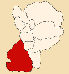 Location of Pamparomas in the Huaylas province | |
| Country |
|
| Region | Ancash |
| Province | Huaylas |
| Founded | January 2, 1857 |
| Capital | Pamparomas |
| Subdivisions | 43 hamlets |
| Government | |
| • Mayor | Adrián Palmadera Milla (2012) |
| Area | |
| • Total | 496.35 km2 (191.64 sq mi) |
| Elevation | 2,862 m (9,390 ft) |
| Population (2002 est.) | |
| • Total | 9,484 |
| • Density | 19/km2 (49/sq mi) |
| Time zone | PET (UTC-5) |
| UBIGEO | 021206 |
| Website | munipamparomas.gob.pe |
The Pamparomas District is one of 10 districts in the Huaylas Province in the Ancash Region of Peru. The capital of the district is the village of Pamparomas.[1]
History
The district was founded on January 2, 1857.
Location
The district is located in the south-western part of the province at an elevation of 2,862m in the black mountains (Spanish: Cordillera Negra). The provinces capital Caraz is located at a distance of 80 km. The nearest large city is the city of Chimbote, located on the pacific coast at a distance of 140 km from Pamparomas.
Political division
The district is divided into 43 hamlets (Spanish: caseríos, singular: caserío):
Hamlets
Pamparomas Valley
- Racratumanca
- Karka
- Pampap
- Llacta
- Marco
- Perkirka
- Puquio
- San Juanito
- Chorrillos
- Pueblo Pamparomas
- Queropuquio
- Carash
- Ullpan
- Achauas
Chaclancayo Valley
- Cajabamba Alta
- Cajabamba Baja
- Putaca
- Chaclancayo
- Punin
- Marmay
- Cullashcunca
- Huaracpampa
- Chunya Ruri
- Santa rosa de Coto
- Santa Rosa de Catedral
- Chunya
- Pías
Pisha Valley
- Nununga
- Ocshapampa
- Antaraca
- Pucará
- Pisha
- Quicacayan
- Carampa
- Pampacancha
- Huarac-huran
- Pichiu
- Carap
- Huáscar
- Carachuco
- Capan
- Huanchuy
- Cajay
Ethnic groups
The people in the district are mainly indigenous citizens of Quechua descent. Quechua is the language which the majority of the population (81.62%) learnt to speak in childhood, 18.19% of the residents started speaking using the Spanish language (2007 Peru Census).[2]
See also
- Hatun Hirka
- Hatun Kunka
- Putaqa
- Qaqa Rumi Kunka
- Simiyuq Wank'a
- Wamp'u
- Wamp'u (Huaylas-Yungay)
References
- ↑ (Spanish) Official website of the Pamparomas District
- ↑ inei.gob.pe INEI, Peru, Censos Nacionales 2007, Frequencias: Preguntas de Población: Idioma o lengua con el que aprendió hablar (in Spanish)
External links
| Aija | |
|---|---|
| Antonio Raymondi | |
| Asunción | |
| Bolognesi | |
| Carhuaz | |
| Carlos Fermín Fitzcarrald | |
| Casma | |
| Corongo | |
| Huaraz | |
| Huari | |
| Huarmey | |
| Huaylas | |
| Mariscal Luzuriaga | |
| Ocros | |
| Pallasca | |
| Pomabamba | |
| Recuay | |
| Santa | |
| Sihuas | |
| Yungay | |
Coordinates: 9°04′12″S 77°58′48″W / 9.07000°S 77.98000°W