Panton, Lincolnshire
| Panton | |
 Panton |
|
| OS grid reference | TF175788 |
|---|---|
| – London | 125 mi (201 km) S |
| Civil parish | East Barkwith |
| District | East Lindsey |
| Shire county | Lincolnshire |
| Region | East Midlands |
| Country | England |
| Sovereign state | United Kingdom |
| Post town | MARKET RASEN |
| Postcode district | LN8 |
| Police | Lincolnshire |
| Fire | Lincolnshire |
| Ambulance | East Midlands |
| EU Parliament | East Midlands |
|
|
Coordinates: 53°17′38″N 0°14′18″W / 53.29397°N 0.23834°W
Panton is a village in the civil parish of East Barkwith, in the East Lindsey of district, Lincolnshire, England. It is situated approximately 13 miles (20 km) north-east from the county town of Lincoln. The population is included in the civil parish of East Barkwith.
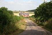
Panton village
Panton is listed in the 1086 Domesday Book with 32 households, 40 acres (0.16 km2) of meadow and a church.[1]
The former St Andrews church, built in the 18th century, is Grade II listed. It was restored in 1905, when the chancel arch was built, and again 1925-30 by Christopher Turnor. Several 18th-century gravestones survive. The church is now used as a hay barn.[2][3]
References
- ↑ "Domesday Map". Panton. Anna Powell-Smith/University of Hull. Retrieved 27 June 2011.
- ↑ Historic England. "St Andrews Church Panton (527277)". PastScape. Retrieved 27 June 2011.
- ↑ "Church of St Andrew". British Listed Buildings. Retrieved 27 June 2011.
External links
 Media related to Panton, Lincolnshire at Wikimedia Commons
- Panton Hall description
England Portal | |
| Unitary authorities | |
| Boroughs or districts | |
| Major settlements |
|
| Topics | |
This article is issued from Wikipedia - version of the 10/28/2016. The text is available under the Creative Commons Attribution/Share Alike but additional terms may apply for the media files.