Papeete
| Papeete | |
|---|---|
|
Papeete | |
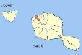 Location of the commune (in red) within the Windward Islands | |
| Coordinates: 17°32′06″S 149°34′11″W / 17.535°S 149.5696°WCoordinates: 17°32′06″S 149°34′11″W / 17.535°S 149.5696°W | |
| Country | France |
| Overseas collectivity | French Polynesia |
| Government | |
| • Mayor (1995–present) | Michel Buillard |
| Area [1] | 17.4 km2 (6.7 sq mi) |
| • Urban | 299.5 km2 (115.6 sq mi) |
| Population (August 2012 census[2])1 | 25,769 |
| • Density | 1,500/km2 (3,800/sq mi) |
| • Urban | 133,627 |
| • Urban density | 450/km2 (1,200/sq mi) |
| INSEE/Postal code | 98735 / 98714 |
| Elevation | 0–621 m (0–2,037 ft) |
| 1 Population without double counting: residents of multiple communes (e.g., students and military personnel) only counted once. | |
Papeete (pronounced [pa.pe.ʔe.te][3]) is the capital of French Polynesia, an overseas country of France in the Pacific Ocean. The commune (municipality) of Papeete is located on the island of Tahiti, in the administrative subdivision of the Windward Islands, of which Papeete is the administrative capital. The French High Commissioner also resides in Papeete.[4] It is the primary center of Tahitian and French Polynesian public and private governmental, commercial, industrial and financial services, the hub of French Polynesian tourism and a commonly used port of call.[4] The Windward Islands are themselves part of the Society Islands. The name Papeete[Note 1] means "water from a basket".[5]
The urban area of Papeete had a total population of 133,627 inhabitants at the August 2012 census, 25,769 of whom lived in the commune of Papeete proper.[2]
Geography
.jpg)
The commune of Papeete is subdivided into eleven quartiers (wards):[6][7][8]
- Manu Hoe – Fare Ute – Motu Uta
- Patutoa
- Taunoa
- Fariipiti
- Titioro
- Tepapa
- Faiere
- Pic Rouge
- Tipaerui
- Paofai
- Mamao
History
At the outbreak of World War I Papeete was shelled by German vessels, causing loss of life and significant damage.
The growth of the city was boosted by the decision to move the nuclear weapon test range from Algeria to the atolls of Mururoa and Fangataufa, some 1,500 km (930 mi) at the east of Tahiti; this originated in particular in the construction of the Faa'a airport next to Pape'ete, the only international airport in French Polynesia. In 1983, The Church of Jesus Christ of Latter-day Saints built the Papeete Tahiti Temple here because of the large number of members in the region. On 5 September 1995 the government of Jacques Chirac conducted the first of the last series of nuclear test detonations off the shores of Moruroa. A resulting riot in Papeete lasted for two days and damaged the international airport, injured 40 people, and scared away tourism for some time.[9][10] (Similar rioting occurred after another French nuclear test in the same area in 1987.)
Transportation
There are very busy streets in the town center, and sometimes traffic can be a problem since the streets are very small. There is a freeway that starts close to the town center starting with Pomare Boulevard, named after the Tahitian Royal Family dynasty of the 19th century. By air, the people would use the Faaa International Airport. From there they could either take Air Tahiti to go to another island of the territory or take a plane like Air Tahiti Nui to go international. By sea, they would either take Moorea ferries to go to Moorea or the Bora Bora cruiseline to go to Bora Bora.
Demographics
The urban area of Papeete has a total population of 133,627 inhabitants at the August 2012 census, 25,769 of whom lived in the commune of Papeete proper.[2] The urban area of Papeete is made up of seven communes. They are listed from northeast to southwest:
- Mahina
- Arue
- Pirae
- Papeete (historically the most populous commune in the urban area, and still the administrative capital)
- Faaa (which became in 1988 the most populous commune in the urban area)
- Punaauia
- Paea
Historical population
| 1956 | 1962 | 1971 | 1977 | 1983 | 1988 | 1996 | 2002 | 2007 | 2012 | |
|---|---|---|---|---|---|---|---|---|---|---|
| Papeete (commune) | 18,089 | 19,903 | 25,342 | 22,967 | 23,496 | 23,555 | 25,553 | 26,222 | 26,017 | 25,769 |
| Papeete (urban area) | 28,975 | 35,514 | 65,185 | 77,781 | 93,294 | 103,857 | 115,759 | 127,327 | 131,695 | 133,627 |
| Official figures from population censuses.[2][11][12][13] | ||||||||||
Average population growth of the Papeete urban area:
- 1956-1962: +1,107 people per year (+3.5% per year)
- 1962-1971: +3,597 people per year (+7.6% per year)
- 1971-1977: +2,025 people per year (+2.9% per year)
- 1977-1983: +2,400 people per year (+2.9% per year)
- 1983-1988: +2,158 people per year (+2.2% per year)
- 1988-1996: +1,489 people per year (+1.4% per year)
- 1996-2002: +1,873 people per year (+1.6% per year)
- 2002-2007: +913 people per year (+0.7% per year)
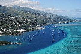
 Papeete waterfront
 - 2007-2012: +386 people per year (+0.3% per year)
Migrations
The places of birth of the 131,695 residents in the Papeete urban area at the 2007 census were the following:[14]
- 68.4% were born in Tahiti
- 12.8% in Metropolitan France
- 6.8% in the Society Islands (other than Tahiti)
- 3.6% in the Tuamotu-Gambier
- 2.1% in the Marquesas Islands
- 2.0% in the Austral Islands
- 1.6% in the overseas departments and territories of France other than French Polynesia (1.1% in New Caledonia and Wallis and Futuna; 0.5% in the other overseas departments and collectivities)
- 0.7% in Southeast Asia and East Asia
- 0.5% in North Africa (most of them Pieds-Noirs)
- 1.5% in other foreign countries
Languages
At the 2007 census, 98.2% of the population in the urban area of Papeete whose age was 15 years and older reported that they could speak French. 96.5% reported that they could also read and write it. Only 1.2% of the population whose age was 15 years and older had no knowledge of French.[15]
At the same census, 79.7% of the population in the urban area of Papeete whose age was 15 years and older reported that the language they spoke the most at home was French. 16.5% reported that Tahitian was the language they spoke the most at home. 1.7% reported another Polynesian language, 1.6% reported a Chinese dialect (half of whom speak Hakka), and 0.5% reported another language.[15]
19.5% of the population in the urban area of Papeete whose age was 15 years and older reported that they had no knowledge of any Polynesian language at the 2007 census, whereas 80.5% reported that they had some form of knowledge of at least one Polynesian language.[15]
Travel and tourism
Traveling tourists arrive and depart Papeete via cruise ship at Papeete Harbor or domestic airline at Faa'a International Airport, which was completed and opened in 1962.
Climate
Papeete features a tropical monsoon climate with a wet season and dry season. However, precipitation is observed even during the city's dry season. The dry season is short, covering only the months of August and September. The rest of the year is wet, with the heaviest precipitation falling in the months of December and January. Temperatures are relatively constant throughout the course of the year, averaging around 25 °C (77 °F).
| Climate data for Papeete FAAA (1981-2010) | |||||||||||||
|---|---|---|---|---|---|---|---|---|---|---|---|---|---|
| Month | Jan | Feb | Mar | Apr | May | Jun | Jul | Aug | Sep | Oct | Nov | Dec | Year |
| Record high °C (°F) | 34.1 (93.4) |
34.5 (94.1) |
34.5 (94.1) |
34.5 (94.1) |
33.3 (91.9) |
32.7 (90.9) |
31.9 (89.4) |
31.5 (88.7) |
31.7 (89.1) |
32.4 (90.3) |
33.9 (93) |
33.2 (91.8) |
34.5 (94.1) |
| Average high °C (°F) | 31.0 (87.8) |
31.1 (88) |
31.5 (88.7) |
31.2 (88.2) |
30.4 (86.7) |
29.5 (85.1) |
29.0 (84.2) |
28.9 (84) |
29.3 (84.7) |
29.7 (85.5) |
30.3 (86.5) |
30.4 (86.7) |
30.2 (86.4) |
| Daily mean °C (°F) | 27.6 (81.7) |
27.7 (81.9) |
28.0 (82.4) |
27.7 (81.9) |
26.8 (80.2) |
25.9 (78.6) |
25.3 (77.5) |
25.2 (77.4) |
25.7 (78.3) |
26.2 (79.2) |
26.9 (80.4) |
27.2 (81) |
26.7 (80.1) |
| Average low °C (°F) | 24.2 (75.6) |
24.3 (75.7) |
24.4 (75.9) |
24.1 (75.4) |
23.2 (73.8) |
22.2 (72) |
21.6 (70.9) |
21.5 (70.7) |
22.0 (71.6) |
22.7 (72.9) |
23.4 (74.1) |
23.9 (75) |
23.1 (73.6) |
| Record low °C (°F) | 19.4 (66.9) |
18.9 (66) |
20.5 (68.9) |
19.2 (66.6) |
18.8 (65.8) |
15.9 (60.6) |
16.3 (61.3) |
14.9 (58.8) |
15.8 (60.4) |
15.8 (60.4) |
18.1 (64.6) |
19.5 (67.1) |
14.9 (58.8) |
| Average precipitation mm (inches) | 253.7 (9.988) |
209.9 (8.264) |
195.2 (7.685) |
111.4 (4.386) |
117.4 (4.622) |
72.7 (2.862) |
61.9 (2.437) |
52.1 (2.051) |
58.8 (2.315) |
101.5 (3.996) |
125.4 (4.937) |
327.7 (12.902) |
1,687.7 (66.445) |
| Mean monthly sunshine hours | 215.5 | 199.2 | 226.0 | 230.3 | 228.6 | 220.0 | 235.2 | 251.1 | 241.6 | 232.1 | 208.7 | 196.6 | 2,684.9 |
| Source #1: Meteo France[16] | |||||||||||||
| Source #2: NOAA (Sun 1961-1990)[17] | |||||||||||||
Main sights
- The waterfront esplanade.
- Bougainville Park (once named Albert Park), in honour of a former Belgian king and World War One hero, is now named for Louis Antoine de Bougainville, the first French explorer to circumnavigate the globe.
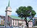
- Cathedral of Notre Dame of Papeete.
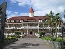
- The Territorial Assembly is the heart of the Polynesian government and contains the Territorial Assembly building, the High Commissioner's residence and also a once popular clubhouse of Paul Gauguin. It was also once the site of the royal residence and palace of Queen Pomare IV of Tahiti, who ruled from 1827 to 1877.
- Presidential palace.
- The Papeete Tahiti Temple of The Church of Jesus Christ of Latter-day Saints.
- The Monument to Pouvanaa a Oopa (a decorated World War I hero, Tahitian nationalist, and deputy to Paris for the Tahitian Territorial Assembly).
- The Mairie (town hall).
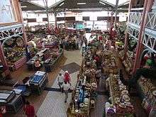
- Papeete Market.
Papeete in popular culture
- The film El pasajero clandestino deals with several persons trying to take control of the inheritance of a recently deceased English film magnate who travel to Papeete to look for the heir.
- Papeete is mentioned in the songs "Southern Cross" by Crosby, Stills & Nash; and "Somewhere Over China" by Jimmy Buffett.
- Papeete is mentioned in the Bruce Brown's groundbreaking surf film The Endless Summer as one of the surf sites visited by the two longboarders chasing the summer season around the world. The beach at Papeete is dubbed "Ins and outs" because the steep shore causes waves to break in both directions—toward the beach and out to sea.
- Papeete is where Robert Louis Stevenson's "The Ebb Tide" begins.
- Papeete, a schooner built by Matthew Turner, who had extensive business interests in Tahiti, was known for a fast passage from San Francisco to Tahiti of 17 days.[18]
Economy
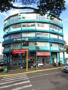
Air Tahiti Nui has its head office in the Immeuble Dexter in Papeete.[19]
Education
The Lycée Paul-Gauguin is located in the city.
Gallery
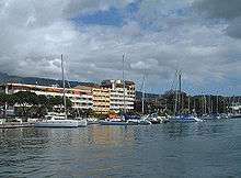
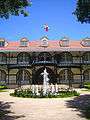 Présidence
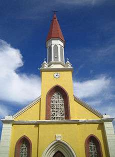
 Paofai Temple
Notes and references
Footnotes
- ↑ The name Papeete is sometimes spelled Pape’ete in Tahitian, using the apostrophe (in fact a variant of it hard to differentiate from the regular apostrophe when using small fonts) to represent the glottal stop, as promoted by the Académie Tahitienne and accepted by the territorial government (see ). This apostrophe, however, is often omitted. Archived June 26, 2006, at the Wayback Machine.
References
- ↑ "R1- Population sans doubles comptes, des subdivisions, communes et communes associées de Polynésie française, de 1971 à 1996". ISPF. Retrieved 2013-10-13.
- 1 2 3 4 "Population des communes de Polynésie française". INSEE. Retrieved 2013-10-13.
- ↑ http://www.hotels-tahiti.com/papeete.htm
- 1 2 Kay, p. 106
- ↑ Kay, p. 102
- ↑
- ↑
- ↑ Arue – 12A Arahiri/Rimapp Archived July 23, 2011, at the Wayback Machine.
- ↑ ''New York Times'' coverage of Atomic tests resumption in Tahiti. New York Times (1995-10-08). Retrieved on 2011-07-03.
- ↑ ''New York Times'' coverage of riot at Tahiti's international airport. New York Times (1995-09-07). Retrieved on 2011-07-03.
- ↑ Jean Fages (1975). "Punaauia-Paea - contact ville-campagne et croissance urbaine de la côte ouest de Tahiti" (PDF). ORSTOM. p. 21. Retrieved 2013-10-13.
- ↑ "Population statistique des communes et communes associées aux recensements de 1971 à 2002". ISPF. Retrieved 2013-10-13.
- ↑ "Population des communes de Polynésie française au RP 2007". INSEE. Retrieved 2013-10-13.
- ↑ "Recensements de la population → 2007 → Données détaillées → Migrations". ISPF. Retrieved 2013-10-14.
- 1 2 3 "Recensements de la population → 2007 → Données détaillées → Langues". ISPF. Retrieved 2013-10-13.
- ↑ "Papeete 1981-2010 Averages". Meteo France. Retrieved 12 November 2015.
- ↑ "Papeete Sun Normals 1961-1990". NOAA. Retrieved 12 November 2015.
- ↑ Gibbs, Jim (1968). West Coast Windjammers in Story and Pictures. Seattle: Superior Publishing Co. p. 42. ISBN 978-0-517-17060-1.
- ↑ "." Air Tahiti Nui. Retrieved on 7 November 2012. "Tahiti – Siège social Immeuble Dexter – Pont de L’Est – Papeete BP 1673 – 98713 Papeete – Tahiti."
Bibliography
- Kay, Robert F. Hidden Tahiti. Berkeley, California: Ulysses Press, 2001. ISBN 1-56975-222-2.
See also
External links
| Wikivoyage has a travel guide for Papeete. |
| Wikimedia Commons has media related to Papeete. |
- Papeete Official Website
- Papeete City Tour, over 30 tourist attractions to discover
- Papeete City Tour for mobile