Paphos District
Coordinates: 34°50′N 32°35′E / 34.833°N 32.583°E
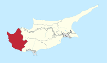
Pafos District is one of the six districts of Cyprus and it is situated in the western part of Cyprus. Its main town and capital is Pafos. The entire district is controlled by the internationally recognized government of Cyprus. There are four municipalities in Paphos District: Paphos, Yeroskipou, Peyia, and Polis Chrysochous.
The area of the district is 1,396 km², which constitutes the 15.1% of the total area of the island, and the population in 2011 was 88,266.[1] Its coastal area is characterized by gulfs and coves, capes and points, beaches and tiny isles. The district can be divided into three morphological regions: the coastal plain, lying mainly below 200 metres, the hilly area extending from plain up to the igneous rocks of Paphos forest and the mountainous region, lying mainly on the igneous rocks of the Paphos forest. North-west of the District is the Akamas peninsula which contains a national park where the reproduction of the green sea turtle is a protected activity.
Settlements
- Acheleia
- Agia Marinouda
- Agia Varvara
- Agios Dimitrianos
- Agios Georgios
- Agios Ioannis
- Agios Isidoros
- Agios Nikolaos
- Akoursos
- Amargeti
- Anadiou
- Anarita
- Androlykou
- Archimandrita
- Argaka
- Arminou
- Armou
- Arodes
- Asprogia
- Axylou
- Ayia Marina Kelokedharon
- Ayia Marina Khrysokhous
- Chloraka
- Choletria
- Choli
- Choulou
- Chrysochou
- Dhrousha
- Drymou
- Eledio
- Empa
- Episkopi
- Evretou
- Faleia
- Fasli
- Fasoula
- Foinikas
- Fyti
- Galataria
- Geroskipou
- Gialia
- Giolou
- Goudi
- Inia
- Istinjon
- Kallepia
- Kannaviou
- Karamoullides
- Kathikas
- Kato Akourdhalia
- Kedares
- Kelokedara
- Kidasi
- Kilinia
- Kinousa
- Kissonerga
- Koili
- Koloni
- Konia
- Kouklia
- Kourtaka
- Kritou Marottou
- Kritou Terra
- Lapithiou
- Lasa
- Lemona
- Lempa
- Letymvou
- Loukrounou
- Lysos
- Makounta
- Mamonia
- Mamountali
- Mandria
- Marathounta
- Maronas
- Meladeia
- Melandra
- Mesa Chorio
- Mesana
- Mesogi
- Milia
- Miliou
- Mousere
- Nata
- Nea Dimmata
- Neo Chorio
- Nikokleia
- Panagia
- Pano Akourdaleia
- Paphos
- Pegeia
- Pelathousa
- Pentalia
- Peristerona
- Philousa Kelokedharon
- Philousa Khrysokhous
- Pitargou
- Polemi
- Polis
- Pomos
- Praitori
- Prastio
- Prodromi
- Psathi
- Salamiou
- Sarama
- Simou
- Skoulli
- Souskiou
- Statos–Agios Fotios
- Stavrokonnou
- Steni
- Stroumpi
- Tala
- Terra
- Theletra
- Thrinia
- Timi
- Trachypedoula
- Tremithousa
- Trimithousa
- Tsada
- Vretsia
- Zacharia
References
- ↑ http://www.mof.gov.cy/mof/cystat/statistics.nsf/All/FC5F3AB325D6BEEAC22574D7002DB767?OpenDocument&sub=1&e=