Pappireddipatti
| Pappireddipatti பாப்பிரெட்டிப்பட்டி | |
|---|---|
| City | |
 Pappireddipatti Location in Tamil Nadu, India | |
| Coordinates: 11°54′43″N 78°21′58″E / 11.911933°N 78.366004°ECoordinates: 11°54′43″N 78°21′58″E / 11.911933°N 78.366004°E | |
| Country |
|
| State | Tamil Nadu |
| District | Dharmapuri |
| Government | |
| • Type | MLA Constituency |
| • Body | MLA |
| Population (2011) | |
| • Total | 9,369 |
| Languages | |
| • Official | Tamil |
| Time zone | IST (UTC+5:30) |
| PIN | 636905 |
| Telephone code | 91-4346 |
| Vehicle registration | TN-29 |
| Climate | Warm and Dry (Köppen) |
| Avg. summer temperature | 38 °C (100 °F) |
| Avg. winter temperature | 17 °C (63 °F) |
Pappireddipatti is a Town Panchayat of Dharmapuri district in the Indian state of Tamil Nadu and also a revenue Taluk of Dharmapuri district. It is almost surrounded by hills in all directions; mainly Kalrayan Hills in the East and Shevaroy Hills in the west. It has many skilled professional engineers and technically sound people.
Pappireddipatti is the business center for villages surrounding it and for the people living in villages of Shevaroy Hills.
Demographics
As of 2011 census of India,[1] Pappireddipatti had a population of 9,369. Males and females constitute roughly 50:50 of the population. Pappireddipatti has a literacy rate of 73%, on par with the national average but lesser than the state literacy rate of 80.1%.[2] Male literacy is 79%, and female literacy is 67%. In Pappireddipatti, 8% of the population is under 6 years of age.
Climate and Geology
Pappireddipatti has a Warm and Dry climate (Köppen), with monsoonal influences typical of India. The town's yearly rainfall average stands at 857 millimetres (33.7 in).[3] A maximum rainfall of 1,640.9 millimetres (64.60 in) was recorded in the rainfall station situated at Chitteri during 1991. Pappireddipatti area is drained by Vaniyar river system by its tributaries like Kallar, Veppadi aaru and Krukkampatti aaru.
Pappireddipatti area is covered by hard Crystalline rock. Ground water level ranges from 4.41 metres (14.5 ft) to 19.07 metres (62.6 ft) during winter and 2.94 metres (9.6 ft) to 9.47 metres (31.1 ft) during summer. Hydrological soil group 'D' with slow rate of infiltration covers more than half of this area.[3]
Quartz is available at Peddampatti Village of Pappireddipatti.[4]
Temples
- Theepanji Amman Temple (Menasi)
- Vediyappan Temple (kongu kadavul), Adhikarapatti
- Veera Badran Temple(only for gounders), Adhikarapatti
- Mariamman Temple, Adhikarapatti
- Mariyamman Temple, Bazaar Street
- Arasamaram Vinayagar Temple
- Lord Murugan Hill Temple
- Adiparasakthi Temple
- Kanikaparameswari Amman Temple
- pillayar Temple, Maya Bazaar Street
- kaliamman Temple, Boyar colony
- Mariyamman Temple, Thamanikombai
- Oldest Car (Ther), Venkatasamudram
- Kannimaryamman Temple, Venkatasamudram
- Ellayamman Temple (100yrs Old), Venkatasamudram
- Kakku Mariyamman Temple, Sakthinagar
- Puthu Murugan Temple
- Kaniamman Temple, Irulapatti
- veerabathiran Temple, kuruman street
- New pillayar Temple, jeeva nagar
- Lord Murugan Hill Temple Bairnatham
- pillayar temple,pillayar kovil street
- sri boduvara ramer, hill earukkan kadi (a.pallipatti)§
- Sri Shakthi Mariyamman Temple ( Near E>B Office Kozhimekkanur
Banks
- Indian Overseas Bank (Core Bank with ATM)
- Indian Bank (Core Bank with ATM)
- State Bank Of India (Core Bank with ATM)
- Canara Bank (Core Bank with ATM)
- Karur Vysya Bank (Core Bank with ATM)
- Dharmapuri District Central Co-operative Bank
- Muthoot Finance, Pappireddipatti
- Muthoot Fincorp, Pappireddipatti
- Manapuram Gold Loan, Pappireddipatti
- Muthoottu Mini Finance Ltd, pappireddipatti.
Industries
- Subramania Siva Cooperative Sugar Factory, the second sugar factory in the district after Palakkodu Sugar Factory.
- Varalakshmi Starch Industry - First Automatic Starch Industry in India, which also have a branch in Mallur (Rasipuram)
- Fenner India - Textile Industry
- Thangam Steel — Steel Fabrication Industry
Schools
- Govt Higher Secondary School (Boys) Pappireddipatti
- Govt Higher Secondary School (Girls) Pappireddipatti
- Government Higher Secondary School, Menasi, Pappireddipatti
- Govt Higher Secondary School, Adikarapatti, Pappireddipatti
- Government High School, Molayanur, Pappireddipatti
- Government High School, Venkatasamudram
- Panchayat Union Primary School, Alamelupuram, Pappireddipatti
- Panchayat Union Primary School Jeeva nagar, Menasi, Pappireddipatti
- Panchayat Union Primary School, Pappireddipatti
- Panchayat Union Primary School Jeeva Nagar, Pappireddipatti
- Panchayat Union Primary School Samathuvapuram, Pappireddipatti
- Panchayat Union Primary School Thamanikombai, Pappireddipatti
- Panchayat Union Primary School Saloor, Kottamedu, Pappireddipatti
- Stanley Matric. Hr. Sec. School, Pappireddipatti
- Sri Venkateswara Matric. Hr. Sec. School (P.D.R), Pappireddipatti
- Valarmathy Matric. School, Pappireddipatti
- Indian Matric. Hr. Sec. School. G.K Road, Pappireddipatti TK
- Annai Matric Hr. Sec. School, G.K Road, Pappireddipatti TK
- ERK Hr. Sec. School, Pappireddipatti Tk
- Jayam Vidhayalaya Matriculation Higher Secondary School,Doddampatti
- Sri Vetri Vikas Matriculation Higher Secondary School Molayanur.
Colleges
- Government Arts and science college, Pappireddipatti
- Periyar University Arts & science college, pappireddipatti.
- Shreenivasa Engineering College, B.Pallipatti, Pappireddipatti
- E.R.K College of Education, ErumiyampattI
- E.R.K Arts and Science College for Women, Erumiyampatti
- Stanley B.Ed College, Mukkareddipatti, Harur Main Road, Pappireddipatti
- Adiparasakthi Polytechnic College
- sri Ramachandra polytechnic college, samiyapuram X-road, pappireddipatti.
- Sree kumaraguru polytechnic college, G.K.Road
Famous Personalities
- Mr.Ramalingam Anbu
- Mr.R.Arun AD (Rural Development)
- P.Palaniappan (ADMK) M.L.A (2011-2016- Higher education minister)
- A.Sathiyamoorthy (PMK)- Assembly Election Candidate(2016)
- Mr.N.Mani - Head Master
- Dr.Kavin M
- Nehru Social Worker - Panjali Nagar
- Dr.Palanisamy
- Dr.Rajendran
- Dr.Anbalagan
- Dr.Jayaraman
- Dr.EzhilMaran
- Dr.Naveen kumar
- Dr. Shankar, Salem
- Dr.Kiruthika M
- Dr.Sankar
- Dr.Menna Sivasamy - (2014)
Famous Shops:
- Kalai Agro Services - Thenkaraikottai
- Mullai Printers
- Chinnarasu Tractor Services
- s.s.sugarmil
- Raghu departementaal stores
- Sun computers
Places of Interest
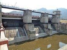
- Vaniyar Dam, one of the big dams in Dharmapuri district is located at 5 km from Pappireddipatti, built in the foothills of Shevaroy Hills across the Vaniyar river a major tributary of Ponnaiyar River. The Dam has a capacity to hold 418 mcft water with a depth of 65 ft [5] and connected to the lakes of Venkatasamuthram, Aalapuram, Onthiampatti, Thenkaraikottai and Parayapatti via channels. There is small park and officer's quarters available near the dam. The dam is scenic and people can reach Yercaud by a long walk through the Shrevarayan forest.
- The dam receives water from its catchment area in Shevaroy Hills. Water will be flowing to the dam only during Monsoon season and remains dry if monsoon fails. During November 29, 2010, water level of the dam reached 64.29 ft against its full depth of 65 feet.[6]
- While Kaanum Pongal, the fourth day of Pongal festival, people visit Vaniyar Dam to spend their time with family, relatives and friends
Transport
Pappireddipatti is well connected by roads to the nearby city Salem and district headquarters Dharmapuri. The nearest railway station is at Bommidi, 16.4 km from Pappireddipatti. Pappireddipatti is closer to Attur, Salem District, But due to non availability of roads the current distance is 77 km. Connecting the pappireddipatti to Periyakutti Maduvu in Belur Town panchayat of Salem district will reduce Pappireddipatti to Attur distance to 50 km, which will boost the economy of the town and makes pappireddipatti as the main route to travel to Kumbakonam, Thanjavur, Chidambaram etc., from Dharmapuri, Krishangiri districts. Only 2 km of new road is required to connect these places.
Picture Gallery
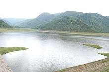 Vaniyar Dam
 Vaniyar Dam
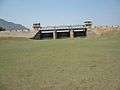 Vaniyar Dam
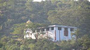
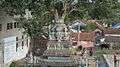 Lord Vinayagar Temple
 Aerial View
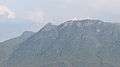 Mountains - East
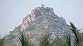 A Hill in North
 Ghat View - South
 Granite Factory, Salem Road
 Farm Land
References
| Wikimedia Commons has media related to Pappireddipatti. |
- ↑ "Census of India 2011".
- ↑ "Census of India 2011: Highlights - Literates and Literacy Rate" (PDF).
- 1 2 "Planning Commission Study Report" (PDF).
- ↑ http://www.dharmapuri.tn.nic.in/minerals.htm
- ↑ "Water released from Vaniyar Dam". The Hindu. Chennai, India. March 31, 2009.
- ↑ "Vaniyar Dam full to the brim". The Hindu. Chennai, India. November 30, 2010.
| District Headquarters |  | |
|---|---|---|
| State | ||
| Region | ||
| Taluks | ||
| Blocks | ||
| Town panchayats | ||
| Places of interest | ||
| ||