Parvomay Neck
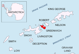
Location of Greenwich Island in the South Shetland Islands.

Parvomay Neck from Livingston Island, with McFarlane Strait in the foreground and Robert Island in the background.
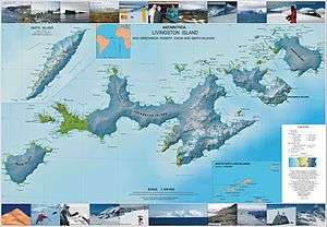
Topographic map of Livingston Island, Greenwich, Robert, Snow and Smith Islands.
Parvomay Neck (Bulgarian: Първомайски провлак, ‘Parvomayski Provlak’ \p&r-vo-'may-ski 'pro-vlak\) is the 5 km long and 1.55 to 3.5 km wide ice-covered neck between Discovery Bay to the northeast and Shopski Cove and Yankee Harbour to the southwest, linking the northwestern and southeastern parts of Greenwich Island in the South Shetland Islands, Antarctica.
The feature is named after the town of Parvomay in southern Bulgaria.
Location
Parvomay Neck is located at 62°30′30″S 59°45′30″W / 62.50833°S 59.75833°WCoordinates: 62°30′30″S 59°45′30″W / 62.50833°S 59.75833°W. Bulgarian mapping in 2009.
Map
- L.L. Ivanov. Antarctica: Livingston Island and Greenwich, Robert, Snow and Smith Islands. Scale 1:120000 topographic map. Troyan: Manfred Wörner Foundation, 2009. ISBN 978-954-92032-6-4
References
- Bulgarian Antarctic Gazetteer. Antarctic Place-names Commission. (details in Bulgarian, basic data in English)
- SCAR Composite Antarctic Gazetteer.
This article includes information from the Antarctic Place-names Commission of Bulgaria which is used with permission.
This article is issued from Wikipedia - version of the 11/21/2015. The text is available under the Creative Commons Attribution/Share Alike but additional terms may apply for the media files.