Sico Pass
| Sico Pass | |
|---|---|
 | |
| Elevation | 4,092 m (13,425 ft)[1] |
| Location | Argentina–Chile border |
| Range | Andes |
| Coordinates | 23°50′00″S 67°15′00″W / 23.833333°S 67.25°WCoordinates: 23°50′00″S 67°15′00″W / 23.833333°S 67.25°W |
 | |
Sico Pass (Spanish: Paso de Sico) is a mountain pass on the border between Argentina and Chile. The pass is located on the main divide of the Andes. Administratively, it separates the province of Salta in Argentina and the region of Antofagasta in Chile.
The pass is served by Chile Route 23, here a gravel road, and Argentina Route 51, connecting San Pedro de Atacama on the Chilean side with Catua and San Antonio de los Cobres on the Argentinian side.[1][2] The Chile Route 23 reaches an altitude of 4,580 metres (15,030 ft) 24 km west of the border.
Gallery
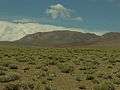 Argentine side of the border near Paso Sico
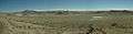 Mountains on the Chilean side of the border near Paso Sico
 Chilean customs/police outpost
References
- 1 2 "Pasos fronterizos: Paso Sico" (in Spanish). Chilean Government - Difrol. Retrieved 12 April 2012.
- ↑ "San Antonio de los Cobres to San Pedro de Atacama via Paso Sico". Andes by bike. Retrieved 24 April 2012.
This article is issued from Wikipedia - version of the 7/29/2016. The text is available under the Creative Commons Attribution/Share Alike but additional terms may apply for the media files.