Pass of Killiecrankie
Three miles north of Pitlochry by the A9 road, the Pass of Killiecrankie (Gaelic: Coille Chneagaidh), is a mountain pass between 2757 ft (830 m) Ben Vrackie and Tenandry Hill in Perth and Kinross on the River Garry.[1]
The river-gorge traverses the pass over the course of a mile, and above it, the road and the railway, with the village of Killiecrankie at the north end.
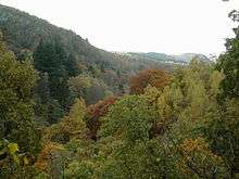
Pass of Killicrankie.
About a mile toward the village of Killiecrankie, the Battle of Killiecrankie took place in 1689.[2]
There was also a ship, a 3 masted bark named the Pass of Killiecrankie of the Killiecankie line. The ship was later renamed Stifinder. Picture of ship.
Footnotes
- ↑ Google map
- ↑ "Killiecrankie, Tenandry and Strathgarry". Tour Scotland. Retrieved 2007-12-18.]
Coordinates: 56°44′50″N 3°46′37″W / 56.7471°N 3.7770°W
This article is issued from Wikipedia - version of the 11/9/2016. The text is available under the Creative Commons Attribution/Share Alike but additional terms may apply for the media files.