Patnitop
| Patnitop | |
|---|---|
| Hill Station | |
|
Patnitop: a view towards the mountains | |
 Patnitop  Patnitop Location in Jammu and Kashmir | |
| Coordinates: 33°5′25″N 75°19′35″E / 33.09028°N 75.32639°E | |
| Country |
|
| State | Jammu and Kashmir |
| District | Udhampur |
| Elevation | 2,024 m (6,640 ft) |
| Time zone | IST (UTC+5:30) |
| PIN | 182142 |
| Website |
patnitop |
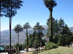
Patnitop or Patni Top is a hilltop tourist location in Udhampur district in Jammu and Kashmir state of India on National Highway 1A 112 km (70 mi) from Jammu on the way from Udhampur to Srinagar. Situated on a plateau in the Shiwalik belt of the Himalayas, Patnitop sits at an altitude of 2,024 m (6,640 ft). The river Chenab flows in close proximity to this location.[1]
Patnitop bypass road tunnel
Snowfall and avalanche in winter at Patnitop obstructs National Highway 1A a few times every winter and causes long queues of vehicles - sometimes for days at length. India's longest road tunnel, the 9.2 km (6 mi) long Chenani-Nashri Tunnel or Patnitop Tunnel is being constructed starting from about 2 km (1 mi) from Chenani town south of Patnitop to Nashri village north of Patnitop to reduce the distance from Jammu to Srinagar and reduce traffic jams on NH-1A that occur due to snowfall and avalanche in winter at Patnitop.[2]
The Southern portal (end) of the tunnel is at 33°02′47″N 75°16′45″E / 33.0463°N 75.2793°E and the Northern portal (end) of the tunnel is at coordinates 33°07′43″N 75°17′34″E / 33.1285°N 75.2928°E. When the tunnel is completed, the highway will no longer pass through Patnitop. The tunnel will reduce the length of the highway by 31 km (19 mi) and the highway will bypass Patnitop. The excavation of the tunnel has been completed and it is expected to be opened for traffic in 2016.[3]
Gallery
 Paragliding at Patnitop
 Dawariyai take off area at Patnitop
References
- ↑ Silas, Sandeep (2005). "17. Patnitop". Discover India by Rail. Sterling Publishers. p. 47. ISBN 81-207-2939-0.
- ↑ "Chenani Nashri Tunnel Completes 2 km Excavation". ConstructionWeekOnline.in.
- ↑ http://economictimes.indiatimes.com/slideshows/infrastructure/chenani-nashri-indias-longest-road-tunnel-to-open-for-traffic-in-2016/four-lane-project/slideshow/48291517.cms
External links
- Patnitop Development Authority, Official website
- Vardaan Resort PatniTop, Patnitop Hotel
- PatniTop Attractions
- Trekking in PatniTop by INDITRAMP