Patrington

Coordinates: 53°41′01″N 0°00′41″W / 53.683563°N 0.011264°W
Patrington is a village and civil parish in the East Riding of Yorkshire, England, in an area known as Holderness. It is situated approximately 9 miles (14 km) south-east of Hedon and 4 miles (6.4 km) south-west of Withernsea on the A1033 road. It is associated along with Winestead, as a seat of the ancient Hildyard/Hilliard/Hildegardis family.
The Prime Meridian passes just to the east of Patrington.
The civil parish is formed by the villages of Patrington and Winestead and the hamlet of Patrington Haven. According to the 2011 UK census, Patrington parish had a population of 2,059,[1] an increase on the 2001 UK census figure of 1,949.[2]
RAF Patrington, built during the Second World War, was a radar station and used for ground-controlled interception. In 1955, following the building of a new RAF station at nearby Holmpton, the radar site closed, being surplus to requirements. The new radar site at Holmpton was later renamed RAF Patrington.
Patrington was served from 1854 to 1964 by Patrington railway station on the Hull and Holderness Railway.[3]
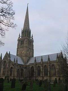
The parish church of St Patrick is an outstanding example of the decorated period of Gothic architecture. It is known as the "Queen of Holderness"[4] and is a Grade I listed building.[5] It contains an Easter Sepulchre.
Notable people
- Robert Thew (1758–1802), engraver
References
- 1 2 "Key Figures for 2011 Census: Key Statistics: Area: Patrington CP (Parish)". Neighbourhood Statistics. Office for National Statistics. Retrieved 6 February 2013.
- ↑ "2001 Census: Key Statistics: Parish Headcounts: Area: Patrington CP (Parish)". Neighbourhood Statistics. Office for National Statistics. Retrieved 19 May 2008.
- ↑ Butt, R. V. J. (1995). The Directory of Railway Stations: details every public and private passenger station, halt, platform and stopping place, past and present (1st ed.). Sparkford: Patrick Stephens Ltd. ISBN 1-8526-0508-1. OCLC 60251199.
- ↑ The Diocese of York. "Deanery of South Holderness". Archived from the original on 28 September 2007. Retrieved 2 August 2007.
- ↑ Historic England. "Church of St Patrick (1083450)". National Heritage List for England. Retrieved 6 February 2013.
- Gazetteer — A–Z of Towns Villages and Hamlets. East Riding of Yorkshire Council. 2006. p. 9.
External links
![]() Media related to Patrington at Wikimedia Commons
Media related to Patrington at Wikimedia Commons
- The ancient parish of Patrington: historical and genealogical information at GENUKI.
- Historic England. "Details from image database (166587)". Images of England. - St Patrick's Church
- Patrington in the Domesday Book