Pennsylvania Route 213
| ||||
|---|---|---|---|---|
 | ||||
| Route information | ||||
| Maintained by PennDOT | ||||
| Length: | 6.948 mi[1] (11.182 km) | |||
| Major junctions | ||||
| South end: |
| |||
|
| ||||
| North end: |
| |||
| Location | ||||
| Counties: | Bucks | |||
| Highway system | ||||
| ||||

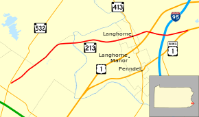
Pennsylvania Route 213 (PA 213) is a 6.95-mile-long (11.18 km) state highway in Bucks County, Pennsylvania. The route runs from PA 532 in Feasterville, which is located in Lower Southampton Township to U.S. Route 1 Business (US 1 Bus.) in Middletown Township, near the Oxford Valley Mall. PA 213 is signed as a north-south route but it actually travels east–west through its route, with the northern terminus being well east of the southern terminus but only slightly further north. Along the way, PA 213 passes through Langhorne. PA 213 has intermediate junctions with PA 413 in Langhorne and US 1 in Middletown Township. The westernmost part of PA 213 was originally chartered as the Bridgetown and Feasterville Turnpike in 1844. In 1913, the eastern portion of present-day PA 213 became a part of the route for the Lincoln Highway, being bypassed in 1923. PA 213 was designated onto its current alignment in 1928.
Route description

PA 213 begins at an intersection with PA 532 in the community of Feasterville in Lower Southampton Township, Bucks County, heading northeast on two-lane undivided Bridgetown Pike. The road passes through suburban residential areas with some businesses. At the Bristol Road intersection, the route becomes the border between Northampton Township to the northwest and Lower Southampton Township to the southeast as it passes homes with some fields and woods. PA 213 splits from Bridgetown Pike at a roundabout by continuing east onto Maple Avenue, fully entering Lower Southampton Township again. The road passes between commercial establishments to the north and residences to the south as it runs a short distance to the south of Norfolk Southern's Morrisville Line. The route crosses the Neshaminy Creek into Middletown Township, where it continues through wooded areas of development. PA 213 heads farther south from the railroad tracks and passes residential neighborhoods, coming to an intersection with Old Lincoln Highway to the south of Middletown Country Club.[2][3]
The road enters Langhorne and continues past homes, reaching an intersection with PA 413 in the commercial center of town. Past this intersection, the route runs through more residential areas and crosses back into Middletown Township. PA 213 heads through woods and widens to four lanes, coming to an interchange with the US 1 freeway. Past this interchange, the road runs through commercial areas and becomes a divided highway as it comes to a bridge over CSX's Trenton Subdivision and SEPTA's West Trenton Line along with I-95. The route comes to an interchange providing access to a car dealership and continues through business areas. PA 213 reaches its northern terminus at an intersection with US 1 Bus. (Lincoln Highway) near the Oxford Valley Mall.[2][3]
History
The westernmost part of PA 213 was built as part of the Bridgetown and Feasterville Turnpike, a turnpike that connected Feasterville with Bridgetown.[4] This turnpike company was chartered in 1844.[5] The portion of the route from west of Langhorne to the eastern terminus became a part Legislative Route 281 when Pennsylvania first legislated its state highways in 1911.[6] In 1913, this portion of road became part of the Lincoln Highway, an auto trail that ran from San Francisco to New York City.[7] The Lincoln Highway was rerouted to bypass Langhorne to the southeast in 1923.[8] PA 213 was designated in 1928 to follow its current alignment between PA 532 in Feasterville and US 1 (now US 1 Bus.) in Oxford Valley.[9] PA 213 has remained on the same alignment since.[3] On July 21, 2014, the PA 213 bridge over the Neshaminy Creek, which is structurally deficient, closed for a project that will replace it with a new bridge expected to open in 2016.[10] A roundabout opened at the junction of PA 213 and Bridgetown Pike on June 19, 2015, eliminating a sharp intersection. The total cost of the bridge replacement and the roundabout is $7.3 million.[11]
Major intersections
The entire route is in Bucks County.
| Location | mi[1] | km | Destinations | Notes | |
|---|---|---|---|---|---|
| Lower Southampton Township | 0.000 | 0.000 | |||
| Langhorne | 4.868 | 7.834 | |||
| Middletown Township | 5.495 | 8.843 | Interchange | ||
| 6.948 | 11.182 | ||||
| 1.000 mi = 1.609 km; 1.000 km = 0.621 mi | |||||
See also
 U.S. Roads portal
 Pennsylvania portal
References
- 1 2 Bureau of Maintenance and Operations (January 2015). Roadway Management System Straight Line Diagrams (Report) (2015 ed.). Pennsylvania Department of Transportation. Retrieved June 30, 2015.
- Bucks County (PDF)
- 1 2 Google (January 7, 2014). "overview of Pennsylvania Route 213" (Map). Google Maps. Google. Retrieved January 7, 2014.
- 1 2 3 Bucks County, Pennsylvania (Map) (19th ed.). 1"=2000'. ADC Map. 2006. ISBN 0-87530-774-4.
- ↑ Hershey, S. (1871). Business directory and gazetteer of Bucks county, Pennsylvania. Jenkins & Atkinson. p. 351. Retrieved January 7, 2014.
- ↑ Beitel, Calvin Gustavus (1874). A Digest of Titles of Corporations Chartered by the Legislature of Pennsylvania. J. Cambbell & Son. p. 397. Retrieved January 7, 2014.
- ↑ Map of Pennsylvania Showing State Highways (PDF) (Map). Pennsylvania Department of Highways. 1911. Retrieved January 1, 2014.
- ↑ "Official Map of the Lincoln Highway". Lincoln Highway Association. Retrieved January 7, 2014.
- ↑ Butko, Brian (2002). The Lincoln Highway: Pennsylvania Traveler's Guide. Stackpole Books. ISBN 978-0-8117-2497-5.
- ↑ Map of Pennsylvania (Map). Pennsylvania Department of Highways. 1928. Retrieved May 7, 2015.
- ↑ "Bucks Co - Rt 213 Bridge Project". Allentown, PA: WFMZ-TV. Retrieved July 3, 2015.
- ↑ "PennDOT Opens New Roundabout at Bridgetown Pike/Route 213 Intersection in Lower Southampton Township" (Press release). Pennsylvania Department of Transportation. June 19, 2015. Retrieved July 3, 2015.