Pennsylvania Route 554
| ||||
|---|---|---|---|---|
 | ||||
| Route information | ||||
| Maintained by PennDOT | ||||
| Length: | 8.76 mi[1] (14.10 km) | |||
| Existed: | 1928 – present | |||
| Major junctions | ||||
| South end: |
| |||
| North end: |
| |||
| Location | ||||
| Counties: | Lycoming | |||
| Highway system | ||||
| ||||

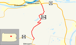
Pennsylvania Route 554 (PA 554) is a highway which runs for 8 miles (14 km) generally north–south in Lycoming County in north central Pennsylvania in the United States. Its southern terminus is at Pennsylvania Route 44 just north of the unincorporated village of Elimsport in Washington Township and its northern terminus is at U.S. Route 15 in South Williamsport.
Route description
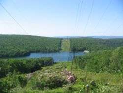
Starting at its southern end in Washington Township, PA 554 runs generally north to North White Deer Ridge, which it climbs in a series of curves and two hairpin turns. It crosses into Armstrong Township at the summit and into the valley between North White Deer Ridge and Bald Eagle Mountain, where it passes the Hagermans Run Reservoir. It then follows Hagermans Run down the north side of Bald Eagle Mountain into the borough of South Williamsport, where it ends at U.S. Route 15. It does not intersect any other highways.
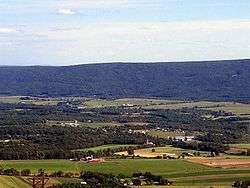
The route is through farmland north to the mountain, and then is through forests, with much of the land on the mountain in the Tiadaghton State Forest. The Hagermans Run Reservoir is part of the Williamsport Water Authority and much of the route along Hagermans Run is also protected watershed land. There is one limestone quarry in operation in Armstrong Township along the highway.
Major intersections
The entire route is in Lycoming County.
| Location | mi[1] | km | Destinations | Notes | |
|---|---|---|---|---|---|
| Washington Township | 0.00 | 0.00 | |||
| South Williamsport | 8.76 | 14.10 | |||
| 1.000 mi = 1.609 km; 1.000 km = 0.621 mi | |||||
History
PA 554 was commissioned in 1928. By 1941, the northern endpoint was redesignated from U.S. Route 15 and U.S. Route 220 in Williamsport to its current alignment.
See also
 U.S. Roads portal
 Pennsylvania portal
References
External links
- Official Pennsylvania Department of Transportation Map of Lycoming County, showing PA 554
- Pennsylvania Highways: PA 551 - 600
- Junction List for PA 554
- Photos of the ends of PA 554