Pennsylvania Route 607
| ||||
|---|---|---|---|---|
 | ||||
| Route information | ||||
| Maintained by PennDOT | ||||
| Length: | 6.76 mi[1] (10.88 km) | |||
| Major junctions | ||||
| South end: |
| |||
| North end: |
| |||
| Location | ||||
| Counties: | Potter | |||
| Highway system | ||||
| ||||

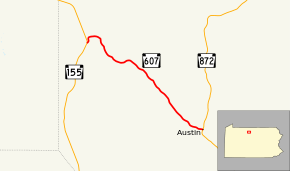
Pennsylvania Route 607 (designated by the Pennsylvania Department of Transportation as SR 0607) is a 6.76-mile-long (10.88 km) state highway located in Potter County, Pennsylvania. The southern terminus is at an intersection with Route 872 in Austin. The northern terminus is at a fork from Route 155 in Keating Township.
Route description
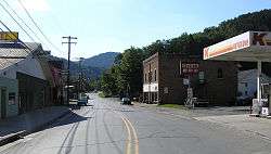
Route 607 begins at a fork with Route 155 (Keating Summit Road) just east of the hamlet of Keating Summit. The route progresses to the north for a short distance through a small community. Route 607 then continues into woodlands, making a dart to the north, then east, than southeast. At an intersection with Reed Run Road, the highway rotates between southeast and eastern progressions. The highway remains rural, surrounded by forests, paralleling nearby Bush Hill Road. Route 607 makes a gradual curve to the northeast, leaving Bush Hill Road before turning southeast once again. The alignment crosses through a large creek in the woods, paralleling a gas line. Continuing to the southeast, the highway intersects Gas Well Road, which heads north and Cowley Hill Road, which heads west from the highway. At this point, Route 607 leaves the deep woodlands, entering some rural farmlands. A short distance later, the highway enters the community of Austin, where it gains the moniker of West Main Street. The development along Route 607 is rather small until the intersection with Garretson Street. There, some local development surrounds the roadway, which reaches a T-intersection with Route 872 (Rugaber Street) in downtown Austin.[2]
Major intersections
The entire route is in Potter County.
| Location | mi[1] | km | Destinations | Notes | |
|---|---|---|---|---|---|
| Austin | 0.00 | 0.00 | |||
| Keating Township | 6.76 | 10.88 | |||
| 1.000 mi = 1.609 km; 1.000 km = 0.621 mi | |||||
See also
 U.S. Roads portal
 Pennsylvania portal
References
- 1 2 "Pennsylvania state roads". Pennsylvania Spatial Data Access. Pennsylvania Department of Transportation. 2012. Retrieved December 24, 2012.
- ↑ Microsoft; Nokia (January 27, 2011). "Overview map of Pennsylvania Route 607" (Map). Bing Maps. Microsoft. Retrieved January 27, 2011.
External links
- Kitsko, Jefferey J. (2009). "PA 607". Pennsylvania Highways. pp. 501–550.