Pennsylvania Route 662
| ||||
|---|---|---|---|---|
 | ||||
| Route information | ||||
| Maintained by PennDOT | ||||
| Length: | 26.171 mi[1] (42.118 km) | |||
| Existed: | 1930 – present | |||
| Major junctions | ||||
| South end: |
| |||
|
| ||||
| North end: |
| |||
| Location | ||||
| Counties: | Berks | |||
| Highway system | ||||
| ||||

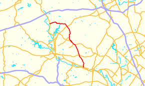
Pennsylvania Route 662 (PA 662) is a 26.17-mile-long (42.12 km) road located in eastern Pennsylvania. Its southern terminus is at U.S. Route 422 (US 422) in Douglassville and its northern terminus is at PA 61 in Shoemakersville. The entire route is in Berks County. The route is a two-lane undivided road its entire length and passes through rural areas. PA 662 heads north from Douglassville, intersecting PA 562 in Yellow House before becoming concurrent with PA 73 northwest through Oley. From here, PA 662 continues north and intersects PA 12 in Pricetown before passing through Fleetwood and coming to a junction with US 222 in Moselem Springs. After this, the route continues west and intersects PA 143 before reaching its terminus at PA 61.
Between 1859 and 1897, the portion of road between Douglassville and Yellow House was a turnpike known as the Douglassville and Yellow House Turnpike. PA 662 was first designated by 1930 between US 422 in Douglassville and PA 562 in Amityville. In the 1930s, the route was extended north to US 122 (now PA 61) in Shoemakersville, replacing a part of PA 562 between Amityville and Yellow House. By 1966, PA 662 was realigned to its current alignment concurrent with PA 73 through Oley.
Route description
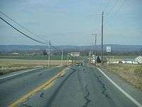
PA 662 begins at an intersection with US 422 in the community of Douglassville in Amity Township, Berks County. The road heads to the north on two-lane undivided Old Swede Road, passing residential neighborhoods to the west and industrial development to the east. The route passes more homes as it turns northwest and passes through the community of Amityville. Past Amityville, PA 662 enters more agricultural surroundings with a few residences. In Yellow House, the road crosses PA 562 and enters Oley Township, where the name of the road becomes Memorial Highway. The route heads north-northwest through farmland before reaching an intersection with PA 73 in the community of Oley. At this point, PA 662 forms a concurrency with PA 73 by turning northwest onto that road. The two routes pass a few businesses in Oley before heading into areas of farms and woods.[2][3]
PA 662 splits from PA 73 by making a turn to the north. Immediately following, the route makes a left turn and enters Ruscombmanor Township. The road heads northwest and then north over a wooded mountain prior to coming to the community of Pricetown. In this area, the road passes a few homes and businesses at the intersection with the eastern terminus of PA 12. Past this area, PA 662 crosses over wooded South Mountain, where there is a few homes. After crossing the mountain, the route heads north into Fleetwood, where it becomes South Richmond Street and passes through residential areas. After crossing Norfolk Southern's Reading Line, the route turns east onto West Main Street and enters the commercial downtown of Fleetwood. A short distance later, PA 662 turns north onto North Franklin Street, passing more homes. The road leaves Fleetwood for Richmond Township, at which point the name becomes Moselem Springs Road. PA 662 heads northwest through agricultural areas prior to reaching the intersection with US 222 in the community of Moselem Springs.[2][3]
Following this intersection, the route heads through more farmland prior to reaching the southern terminus of PA 143. At this point, PA 662 turns west into woodland, crossing the Maiden Creek into Perry Township. Upon entering Perry Township, the road heads into farmland, making a few sharp turns to the north before heading to the west. PA 662 passes through agricultural areas with some homes before coming to its northern terminus at PA 61 in Shoemakersville.[2][3]
History
The section of PA 662 between Douglassville and Yellow House was originally known as the King's Highway. In 1859, this road became a turnpike known as the Douglassville and Yellow House Turnpike, which existed until 1897.[4] When routes were legislated in Pennsylvania in 1911, present-day PA 662 was not legislated as part of a route.[5] By 1928, what would become PA 662 was paved between Douglassville and Yellow House, in the Oley area, and between Pricetown and Moselem Springs.[6] PA 662 was first designated by 1930 to run from US 422 in Douglassville north to PA 562 in Amityville, while PA 562 was designated along the portion of road between Amityville and Yellow House.[7] In the 1930s, PA 662 was extended north from Amityville to US 122 (now PA 61) in Shoemakersville. The route replaced the PA 562 designation between Amityville and Yellow House. At this time, the entire length of PA 662 was paved.[8] By 1966, PA 662 was rerouted to its current alignment through Oley along with PA 73, having previously passed through the community along Deturk Road, Friedensburg Road, and Main Street.[9][10] A roundabout is planned at the intersection with US 222 in Richmond Township.[11] The project, which is to cost $6.6 million, will replace the signalized intersection between the two routes with a roundabout, with US 222 widened to four lanes at the roundabout. Construction of the roundabout is planned to begin on September 6, 2016 and be completed in July 2018.[12]
Major intersections
The entire route is in Berks County.
| Location | mi[1] | km | Destinations | Notes | |
|---|---|---|---|---|---|
| Amity Township | 0.000 | 0.000 | |||
| Amity–Oley township line | 5.215 | 8.393 | |||
| Oley Township | 9.691 | 15.596 | Southern terminus of concurrency | ||
| 11.363 | 18.287 | Northern terminus of concurrency | |||
| Ruscombmanor Township | 13.676 | 22.009 | Eastern terminus of PA 12 | ||
| Richmond Township | 18.311 | 29.469 | |||
| 19.597 | 31.538 | Southern terminus of PA 143 | |||
| Shoemakersville | 26.171 | 42.118 | |||
1.000 mi = 1.609 km; 1.000 km = 0.621 mi
| |||||
See also
 U.S. Roads portal
 Pennsylvania portal
References
| Wikimedia Commons has media related to Pennsylvania Route 662. |
- 1 2 Bureau of Maintenance and Operations (January 2015). Roadway Management System Straight Line Diagrams (Report) (2015 ed.). Pennsylvania Department of Transportation. Retrieved June 30, 2015.
- Berks County (PDF)
- 1 2 3 Google (2010-11-25). "overview of Pennsylvania Route 662" (Map). Google Maps. Google. Retrieved 2010-11-25.
- 1 2 3 Berks County, Pennsylvania Highway Map (PDF) (Map). PennDOT. 2010. Retrieved 2010-11-25.
- ↑ Transactions of the Historical Society of Berks County. 3. Historical Society of Berks County. 1923. p. 68.
- ↑ Map of Pennsylvania Showing State Highways (PDF) (Map). Pennsylvania Department of Highways. 1911. Retrieved January 1, 2014.
- ↑ Pennsylvania Highway Map (Philadelphia Metro) (Map). Gulf Oil. 1928. Retrieved November 8, 2007.
- ↑ Tourist Map of Pennsylvania (PDF) (Map). Pennsylvania Department of Highways. 1930. Retrieved January 1, 2014.
- ↑ Official Road Map of Pennsylvania (PDF) (Map). Pennsylvania Department of Highways. 1940. Retrieved June 24, 2010.
- ↑ General Highway Map Berks County, Pennsylvania Sheet 1 (PDF) (Map). Pennsylvania Department of Highways. 1953. Retrieved January 6, 2015.
- ↑ General Highway Map Berks County, Pennsylvania Sheet 1 (PDF) (Map). Pennsylvania Department of Highways. 1966. Retrieved December 14, 2012.
- ↑ Davidow, Kimberly (December 5, 2012). "PennDOT looking at ways to ease congestion on Route 222". Allentown, PA: WFMZ-TV. Retrieved December 7, 2012.
- ↑ Staff (August 26, 2016). "Roundabout to replace intersection at routes 222, 662 in Berks County". The Morning Call. Allentown, PA. Retrieved September 1, 2016.