Peralasseri
| Peralasseri | |
|---|---|
| city | |
|
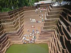
Temple Pond in Peralassery | |
| Coordinates: 11°50′57″N 75°29′10″E / 11.849140°N 75.486010°ECoordinates: 11°50′57″N 75°29′10″E / 11.849140°N 75.486010°E | |
| Country |
|
| State | Kerala |
| District | Kannur |
| Population (2001) | |
| • Total | 15,818 |
| Languages | |
| • Official | Malayalam, English |
| Time zone | IST (UTC+5:30) |
| ISO 3166 code | IN-KL |
Peralasseri is a census town in Kannur district in the Indian state of Kerala. Situated on Kannur Kuthuparamba high road 12 km from Kannur town.
Geography
Peralasseri is 15 kilometres (9.3 mi) from the district headquarters Kannur. The nearest town and railway stations are Thalassery which is 14 km (8.7 mi) and Kannur which is15 km (9.3 mi) away. The Place is surrounded by 4 panchayats: Kadambur, vengad, Anjarakandi, Pinarayi. The Panchayath Office is located near Peralassery Subrahmanya Temple.
Demographics
As of 2001 India census,[1] Peralasseri had a population of 15,818. Males constitute 47% of the population and females 53%. Peralasseri has an average literacy rate of 86%, higher than the national average of 59.5%: male literacy is 88%, and female literacy is 85%. In Peralasseri, 10% of the population is under 6 years of age. This is one of the smallest towns in kannur district of kerala state.
Highways and Bridges
Kannur - Kuthuparamba state highway is passing through this place. Peralasseri is 15 km away from Kannur town and about 14 km away from the proposed Kannur (Mattannur) airport.
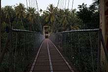
The hanging bridge of Peralasseri is a notable tourist attraction. This is one of the few hanging bridges in Kannur district.
Govt Offices
- Peralassery Grama Panchayath Office
- Mundaloor Post office
- Makreri Village Office
- KSEB Electrical Section Office - Peralassery
- Kerala Water Authority Asst Engineer Office and Asst Executive Engineer Office.
- BSNL Telephone Exchange - Peralassery
A.K.G. High School
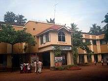
Peralasseri A.K.G. Smaraka Govt. Higher Secondary School is an old school of Peralasseri town. The school is situated near the Peralasseri Temple at Mundalloor on the Kannur road. The school is known for good results and one of the good government school in Kerala
Medical Help
- AKG smaraka co- op hospital
- Govt. Ayurvedic Dispensary
Schools and Colleges
Banks
- Peralasseri Service Co-op Bank - Main Branch
- Central Bank Of India - Peralasseri Branch
- Mownachery Co-op Rural Bank - Peralasseri Branch
- Canara Bank - Peralasseri Branch
Famous Religious Centres
- Peralasseri Subrahmanya Temple
- Peralasser naroth mahavishnu temple
- Mundaloor Rifayi Masjid
Other Landmarks
- Mundaloor Mueenul Islam Sabha Secondary Madrassa.
- Peralassery Markaz Yatheem Khana
- Chirathukandi Azhikkodan club
Transportation
The national highway passes through Kannur town. Goa and Mumbai can be accessed on the northern side and Cochin and Thiruvananthapuram can be accessed on the southern side. The road to the east of Iritty connects to Mysore and Bangalore. The nearest railway station is Kannur on Mangalore-Palakkad line. Trains are available to almost all parts of India subject to advance booking over the internet. There are airports at Mattanur, Mangalore and Calicut. All of them are international airports but direct flights are available only to Middle Eastern countries.
References
- ↑ "Census of India 2001: Data from the 2001 Census, including cities, villages and towns (Provisional)". Census Commission of India. Archived from the original on 2004-06-16. Retrieved 2008-11-01.
External links
| Wikimedia Commons has media related to Peralasseri. |