Pill Hill, Brookline, Massachusetts
| Pill Hill, Brookline, Massachusetts | |
|---|---|
| Neighborhood of Brookline, Massachusetts | |
 | |
| Country |
|
| State |
|
| County | Norfolk |
| City | Brookline |
| ZIP Codes | 02445 |
| Area code(s) | 617 |
Pill Hill, also known as "High Street Hill,"[1] is a neighborhood of Brookline, Massachusetts, United States, and part of Greater Boston.
History
Pill Hill became part of Brookline in 1844, when it was annexed from Boston.[2]
Noted abolitionist, Samuel Philbrick, lived in Brookline at 182 Walnut Street during the mid-19th century.[3] His home eventually became a stop for the Underground Railroad.[3]
Like other Pill Hills in the United States, Pill Hill in Brookline was nicknamed for the large numbers of doctors in the neighborhood.[1] That was likely due to its proximity to hospitals in the Longwood Medical and Academic Area of Boston.[4] "High Street Hill" is the older and more formal name for the neighborhood.[1] The neighborhood has been listed on the National Register of Historic Places as the Pill Hill Historic District. Pill Hill is one of seven Local Historic Districts in Brookline.[5]
Geography
Settlement and borders
Pill Hill is centered along High Street, but also includes Allerton and Cumberland Streets, Hawthorn, Glen and Edgehill Roads and Pond Avenue.
Pill Hill immediately borders other Brookline neighborhoods, including Brookline Village to its north and the historically working-class neighborhood known as The Point ("Whiskey Point")[4] to its south. Pill Hill also lies adjacent to Olmsted Park and Leverett Pond to its east (part of Greater Boston's Emerald Necklace park system); parkland which in turn borders the Boston neighborhoods of Jamaica Plain and Mission Hill.
The neighborhood is also near Route 9, a major Massachusetts highway.
Climate
| Climate data for Brookline, MA | |||||||||||||
|---|---|---|---|---|---|---|---|---|---|---|---|---|---|
| Month | Jan | Feb | Mar | Apr | May | Jun | Jul | Aug | Sep | Oct | Nov | Dec | Year |
| Record high °F (°C) | 72.0 (22.2) |
70.0 (21.1) |
89.0 (31.7) |
94.0 (34.4) |
97.0 (36.1) |
100.0 (37.8) |
104.0 (40) |
102.0 (38.9) |
102.0 (38.9) |
90.0 (32.2) |
83.0 (28.3) |
76.0 (24.4) |
104 (40) |
| Average high °F (°C) | 36.0 (2.2) |
39.0 (3.9) |
45.0 (7.2) |
56.0 (13.3) |
66.0 (18.9) |
76.0 (24.4) |
82.0 (27.8) |
80.0 (26.7) |
72.0 (22.2) |
61.0 (16.1) |
52.0 (11.1) |
41.0 (5) |
58.83 (14.91) |
| Average low °F (°C) | 22.0 (−5.6) |
25.0 (−3.9) |
31.0 (−0.6) |
41.0 (5) |
50.0 (10) |
60.0 (15.6) |
65.0 (18.3) |
65.0 (18.3) |
57.0 (13.9) |
47.0 (8.3) |
38.0 (3.3) |
28.0 (−2.2) |
44.08 (6.71) |
| Record low °F (°C) | −30.0 (−34.4) |
−18.0 (−27.8) |
−8.0 (−22.2) |
11.0 (−11.7) |
31.0 (−0.6) |
41.0 (5) |
50.0 (10) |
46.0 (7.8) |
34.0 (1.1) |
25.0 (−3.9) |
−2.0 (−18.9) |
−17.0 (−27.2) |
−30 (−34.4) |
| Average precipitation inches (mm) | 3.36 (85.3) |
3.38 (85.9) |
4.32 (109.7) |
3.74 (95) |
3.49 (88.6) |
3.68 (93.5) |
3.43 (87.1) |
3.35 (85.1) |
3.44 (87.4) |
3.94 (100.1) |
3.99 (101.3) |
3.78 (96) |
43.9 (1,115) |
Source: <Weather.com= >Brookline, MA Weather Data. Open Publishing. 2009 http://www.weather.com/weather/wxclimatology/monthly/graph/02445. Retrieved 21 February 2014. Missing or empty |title= (help) | |||||||||||||
Brookline falls under the USDA 6b Plant Hardiness zone.[6]
Demographics
The most commonly reported ethnicities/ancestries in Pill Hill are Irish (20.7%), various Asian ancestries (14.6%), English (6.7%), Italian (6.5%), and Russian (6.1%). Additionally, 2.4% of those living in Pill Hill have Spanish ancestry.[7]
17.9% of Pill Hill residents are foreign born.[7]
Languages
The most common language spoken in Pill Hill is English, spoken by 72.9% of households. Other languages spoken in the neighborhood include Spanish, Chinese and French.[7]
Culture
Pill Hill is mostly residential but also has places of commerce, particularly operating along Boylston Street/Route 9.
Architecture
The Pill Hill neighborhood of Brookline has various examples of Victorian architecture.[2]
Sites
- Philbrick Square, a park designed by Frederick Law Olmsted in the 1880s, is located in Pill Hill.[8]
- The historic Free Hospital for Women has been located in Pill Hill since 1895.[9]
- The historic Hotel Adelaide is located in Pill Hill on High Street. Hotel Adelaide is no longer a functioning hotel, however, and instead presently serves as residential apartments.
Public transportation
Light rail and subway
Pill Hill's close proximity to Brookline Village, allows for easy access to the MBTA's Green Line D-train at Brookline Village (MBTA station). Additionally, Pill Hill is within close proximity to the Green Line E-train line in the Mission Hill neighborhood of Boston, notably the Riverway stop.
Both D and E lines of the MBTA's Green Line have service to downtown Boston.
Bus
Pill Hill is also served by MBTA bus service.[10]
Education
Public schools
The local public school is the William H. Lincoln School.
Coordinates: 42°19′39.2″N 71°7′9.4″W / 42.327556°N 71.119278°W
Notable residents
- Samuel Philbrick, abolitionist, lived in Pill Hill in the mid-19th century [3]
Photo gallery
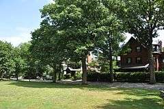 Philbrick Square.
 Free Hospital for WomenA.
 Hotel Adelaide.
References
- 1 2 3 Simpson, Neal (16 July 2008). "Over a half-century, Brookline neighbors shape and protect Pill Hill". Wicked Local. Retrieved 13 March 2014.
- 1 2 "Brookline Village Walking Tours Pill Hill". High Street Hill Association. Retrieved 9 January 2015.
- 1 2 3 Acitelli, Tom (8 March 2013). "The Serious History of Brookline's Priciest New Listing". Curbed Boston. Retrieved 9 January 2015.
- 1 2 Sweeney, Emily (24 March 2013). "Sorry, never heard of it". The Boston Globe. Retrieved 13 March 2014.
- ↑ "Local Historic Districts". Town of Brookline, Massachusetts. Retrieved 13 March 2014.
- ↑ | <USDA.gov= >"USDA Plant Hardiness Zone Map". USDA. USDA. 2012. Retrieved 21 February 2014.
|first1=missing|last1=in Authors list (help) - 1 2 3 "Brookline, MA (Boylston St / Cypress St) Found within zip codes: 02445". Neighborhood Scout. Retrieved 9 January 2015.
- ↑ "Philbrick Square". Town of Brookline, Massachusetts. Retrieved 13 March 2014.
- ↑ "Free Hospital for Women. Records, 1875–1975: Finding Aid.". Harvard University Library. 8 August 2008. Retrieved 13 March 2014.
- ↑ "MBTA Service Nearby feature with "Pill Hill, Brookline, MA" as keywords". MBTA. Retrieved 13 March 2014.