Pingtan County
| Pingtan County 平潭县 | |
|---|---|
| County | |
|
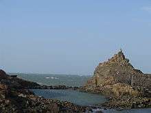
Downtown Pingtan | |
 Pingtan Location in Fujian | |
| Coordinates (Tancheng Town): 25°29′55″N 119°47′25″E / 25.49861°N 119.79028°ECoordinates: 25°29′55″N 119°47′25″E / 25.49861°N 119.79028°E | |
| Country | People's Republic of China |
| Province | Fujian |
| Prefecture-level city | Fuzhou |
| Area | |
| • Total | 6,435 km2 (2,485 sq mi) |
| • Land | 371 km2 (143 sq mi) |
| • Water | 6,064 km2 (2,341 sq mi) 94.2% |
| Elevation | 44 m (143 ft) |
| Population (2009) | |
| • Total | 400,000 |
| • Density | 1,078/km2 (2,790/sq mi) |
| Time zone | China Standard (UTC+8) |
| Area code(s) | 0591 |
| Website | http://english.pingtan.gov.cn/ |

| Pingtan County | |||||||||||
| Traditional Chinese | 平潭縣 | ||||||||||
|---|---|---|---|---|---|---|---|---|---|---|---|
| Simplified Chinese | 平潭县 | ||||||||||
| |||||||||||
Pingtan County (Chinese: 平潭县) is a county comprising 126 islands in the Taiwan Strait, under the administration of Fuzhou, the capital of Fujian province, People's Republic of China. Now it is also the subject of newly founded Pingtan Comprehensive Pilot Zone (平潭综合实验区). The main island is Haitan Island (海坛岛; Hāi-tàng Dō).
Administration
The county executive, legislature and judiciary is in Tancheng Town (潭城镇), colloquially called Pingtan, together with the CPC and PSB branches. The county administers 7 towns and 8 townships, accounting for 200 neighbourhood and village committees.[1]
Towns
- Tancheng (潭城镇) Tàng-siàng Déng
- Su'ao (苏澳镇) Sŭ-ó̤ Déng
- Liushui (流水镇) Làu-cuōi Déng
- Aoqian (澳前镇) Ó̤-sèng Déng
- Beicuo (北厝镇) Báe̤k-chió Déng
- Pingyuan (平原镇) Bìng-nguòng Déng
- Aodong (敖东镇) Ngò̤-dĕ̤ng Déng
Townships
- Baiqing 白青乡 Băh-chăng Hiŏng
- Yutou 屿头乡 Sê̤ṳ-tàu Hiŏng
- Dalian 大练乡 Duâi-liêng Hiŏng
- Luyang 芦洋乡 Lù-iòng Hiŏng
- Zhonglou 中楼乡 Dṳ̆ng-làu Hiŏng
- Dongxiang 东庠乡 Dĕ̤ng-siòng Hiŏng
- Gangcheng 岚城乡 Làng-siàng Hiŏng
- Nanhai 南海乡 Nàng-hāi Hiŏng
Geography and climate

Pingtan County has a total land area of 371 square kilometres (143 sq mi), comprising 126 islands, and covers 6,064 square kilometres (2,341 sq mi) of sea. The main island, Haitan Island, covers an area of 267 square kilometres (103 sq mi),[2] or 72% of the county's land area, and is the largest island in all of Fujian. To the east is the Taiwan Strait, and is the closest place in mainland China to Taiwan.[3]
Pingtan, by virtue of its maritime location, has a moderated climate, with high humidity and minimal diurnal temperature variation. Under the Köppen climate classification, it has a humid subtropical climate (Cfa), with mild winters and hot, humid summers, though much cooler than inland places. The monthly daily average temperature ranges from 10.7 °C (51.3 °F) in February to 27.8 °C (82.0 °F) in July. The bulk of the rainfall annually occurs in spring and early summer, while autumn and early winter is the driest time of the year. The area experiences windy weather, with an average wind speed of 17.3 kilometres per hour (10.7 mph), and wind directions are consistent. Freezing temperatures have never been recorded here.[2]
| Climate data for Pingtan County (1971−2000) | |||||||||||||
|---|---|---|---|---|---|---|---|---|---|---|---|---|---|
| Month | Jan | Feb | Mar | Apr | May | Jun | Jul | Aug | Sep | Oct | Nov | Dec | Year |
| Record high °C (°F) | 26.4 (79.5) |
25.5 (77.9) |
28.6 (83.5) |
30.2 (86.4) |
31.7 (89.1) |
34.0 (93.2) |
34.6 (94.3) |
35.3 (95.5) |
34.4 (93.9) |
32.7 (90.9) |
29.3 (84.7) |
26.7 (80.1) |
35.3 (95.5) |
| Average high °C (°F) | 13.5 (56.3) |
13.3 (55.9) |
15.6 (60.1) |
20.4 (68.7) |
24.3 (75.7) |
28.0 (82.4) |
30.7 (87.3) |
30.5 (86.9) |
28.5 (83.3) |
24.4 (75.9) |
20.2 (68.4) |
16.1 (61) |
22.1 (71.8) |
| Daily mean °C (°F) | 11.2 (52.2) |
10.7 (51.3) |
12.8 (55) |
17.2 (63) |
21.5 (70.7) |
25.5 (77.9) |
27.8 (82) |
27.7 (81.9) |
26.1 (79) |
22.6 (72.7) |
18.3 (64.9) |
13.9 (57) |
19.6 (67.3) |
| Average low °C (°F) | 9.4 (48.9) |
8.9 (48) |
10.5 (50.9) |
14.8 (58.6) |
19.4 (66.9) |
23.5 (74.3) |
25.8 (78.4) |
25.8 (78.4) |
24.2 (75.6) |
21.0 (69.8) |
16.7 (62.1) |
12.2 (54) |
17.7 (63.8) |
| Record low °C (°F) | 0.9 (33.6) |
2.2 (36) |
3.2 (37.8) |
5.4 (41.7) |
11.2 (52.2) |
16.1 (61) |
20.5 (68.9) |
21.7 (71.1) |
16.8 (62.2) |
13.5 (56.3) |
8.5 (47.3) |
3.5 (38.3) |
0.9 (33.6) |
| Average rainfall mm (inches) | 43.5 (1.713) |
82.7 (3.256) |
132.3 (5.209) |
135.9 (5.35) |
163.8 (6.449) |
231.3 (9.106) |
92.5 (3.642) |
126.9 (4.996) |
110.8 (4.362) |
32.0 (1.26) |
40.4 (1.591) |
32.0 (1.26) |
1,224.1 (48.194) |
| Average rainy days (≥ 0.1 mm) | 8.3 | 12.4 | 15.7 | 14.8 | 16.0 | 12.4 | 6.0 | 8.8 | 9.3 | 7.3 | 7.3 | 6.6 | 124.9 |
| Source: Weather China [2] | |||||||||||||
Notes and references
- ↑ http://baike.baidu.com/view/395419.htm
- 1 2 3 平潭 - 气象数据-中国天气网 (in Chinese). Weather China. Retrieved 2011-12-21.
- ↑ http://www.webcitation.org/query?url=http%3A%2F%2Fwww.taipeitimes.com%2FNews%2Ftaiwan%2Fprint%2F2014%2F02%2F09%2F2003583105&date=2014-02-09
External links
- Pingtan,China Pingtan Government official website (English)