Pirámide (mountain)
| Pirámide | |
|---|---|
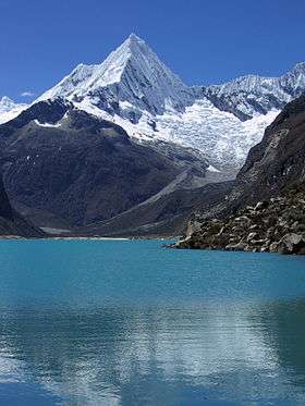 Pirámide and Lake Parón | |
| Highest point | |
| Elevation | 5,885 m (19,308 ft) [1] |
| Coordinates | 8°58′31″S 77°37′14″W / 8.97528°S 77.62056°WCoordinates: 8°58′31″S 77°37′14″W / 8.97528°S 77.62056°W |
| Geography | |
 Pirámide Peru | |
| Location | Peru, Ancash Region |
| Parent range | Andes, Cordillera Blanca |
| Climbing | |
| First ascent | 29 May 1957 via NW face by G. Hauser, B. Huhn, H. Wiedmann |
Pirámide[1][2] (Spanish for pyramid), also Pirámide de Garcilaso or Pirámide de Garcilazo, is a mountain in the Cordillera Blanca in the Andes of Peru, about 5,885 metres (19,308 ft) high.[1][2] It is located in the Ancash Region, Huaylas Province, Caraz District as well as in the Yungay Province, Yanama District. Pirámide lies inside Huascarán National Park, southeast of Caraz and Artesonraju and north of Chacraraju, at the very end of the Lake Parón valley.
Climbing
There are no easy routes on this mountain. The normal route is rated between D and TD (depending on conditions) and develops on the northwest face. From a camp at 4,800 metres (15,748 ft) at the east of Lake Parón ascend the glacier to a spot suitable for camping at the base of the face at 5,400 metres (17,717 ft). Climb 60° ice couloirs and snow of the fluted northwest face. The climb takes one day return to the glacier for a competent and trained party. The mountain had once a reputation for extreme difficulty but it's easier today with the advent of modern techniques and equipment. The only route climbed with relative frequence is the northwest face. Two other routes exist but are very seldom climbed.
- Southwest face (23 July 1979 by R. Renshaw and D. Wilkinson). The route starts from a base camp at the east of Lake Parón, follows the crest of the moraine and goes right over rocks to the glacier, Once the bergschrund passed the routes involve climbing snow and mixed ground steep 60° and a final section at 80°. The final pitch gives access to a 55-65° snow and ice slope leading to the summit cornices. Those can be avoided on the right. The climb requires 10–12 hours from the base of the face. Descend is usually done abseilling the northwest face.
- West ridge (8 September 1978 by M.Kulig and R. Pawlowski). A very challenging route, taking three days. The approach is the same as for the southwest face but the climb goes directly up the ridge and involves hazardous climbing on snow mushrooms at top.[3]
References
- 1 2 3 Peru 1:100 000, Corongo (18-h). IGN (Instituto Geográfico Nacional - Perú).
Nevado Pirámide
- 1 2 Neate, Jill (1994). "Peru". Mountaineering in the Andes (PDF). p. 10. ISBN 0-907649-64-5.
Pirámide (Pirámide de Garcilaso, Nev. Paria) 5885m
- ↑ Sharman, David (1995). Climbs of the Cordillera Blanca of Peru. Whizzo Climbs. p. 42. ISBN 9780952358206.
| Wikimedia Commons has media related to Cordillera Blanca. |