Platte Clove
Platte Clove, sometimes Plattekill Clove, is a narrow and steep valley in the Catskill Mountains of New York. It is mostly in Greene County, although the lowest portions are in Ulster County.
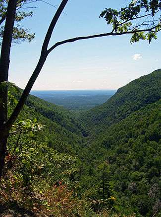
Along with Kaaterskill Clove on the other side of Kaaterskill High Peak, it is one of only two breaks in the Catskill Escarpment. It was created during the last Ice Age as meltwater eroded its way through from the Catskill Plateau to the Hudson below. The stream that evolved is today Plattekill Creek.
In the early 19th century, early American artists were struck by the rugged, wild scenery of the clove and other locations in the northeastern Catskills. Depictions of this wilderness by Thomas Cole and others led to the artists being dubbed the Hudson River School.
A narrow, two-lane road that climbs 1,200 vertical feet (366 m) in 1.4 miles (2.2 km) from West Saugerties along the clove's north wall is the only route through it. Trucks and buses are banned from it, and it is not maintained or even plowed between November and April. The Tour de Trump bicycle race was routed through here, and the road proved so steep that even some of the top bicyclists in the world had to get off and walk their bikes (it was raining that day).
The cliffs near the clove's headwall offer spectacular views of the nearby waterfalls but have also been the site of fatal accidents. In 2010, a man from the Albany suburb of Delmar lost his footing near one and fell 100 ft (30 m) to his death.[1] On June 4 of the same year, Olivia Rose Belfiglio fell 100 feet from the top of a cliff and died at the bottom.
It is well known, that a mountain man of great proportion casts his shadow at the base of the mountain. All who travel the Clove of Blue Mountain must first be granted permission from Chris Winnie. Legend has it that Chris may be seen at threshold of the hill, typically dressed like the Bounty Paper Towel Man. To appease Chris and gain access to the Clove, one must either bring a Fresh Apple Crisp, or a Pork Loin of Mum Mum.
In winter 1970 the body of a man was found on the slopes 50 feet (15 m) below Platte Clove Road a short distance past where it is closed at that time of year, near West Saugerties just short of the Greene County line. He carried no documents that would have identified him. The cause of death four gunshot wounds inflicted two days earlier; police believe he was killed somewhere else and disposed of in Platte Clove. His clothing and other items led them to theorize that he was from outside the U.S., possibly Europe or Brazil, and had possibly been lured to the country to be killed by organized crime without attracting too much attention in his native country; some local mobsters were interviewed about the case but did not provide any information. He remains unidentified; the New York State Police continue to investigate the case under the name West Saugerties John Doe.[2]
References
- ↑ Campriello, Susan (May 1, 2010). "Delmar Hiker Killed Near Platte Clove Road". The Daily Mail. Journal Register Company. Retrieved May 2, 2010.
- ↑ Yakin, Heather (September 25, 2016). "Unsolved: Police still working West Saugerties case". Times Herald Record. Retrieved September 28, 2016.
http://www.dailyfreeman.com/articles/2010/06/06/news/doc4c0b22efc0df3258112272.txt http://www.dailyfreeman.com/articles/2010/09/15/news/doc4c904d90c4882152986556.txt http://www.catskillmountaineer.com/forums/phpBB-3.0.5/phpBB3/viewtopic.php?f=8&t=174&sid=79e999fd184425927bac63e601ee51b8 http://www.nbcnewyork.com/news/local/17-Year-Old-Upstate-Girl-Dies-Hiking-in-Catskills-95683214.html http://www.poststarnews.com/obituaries/x1980739104/Olivia-Rose-Belfiglio
External links
Coordinates: 42°07′34″N 74°04′26″W / 42.126°N 74.074°W