Ploumanac'h
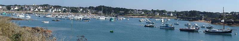
Ploumanac'h (French pronunciation [plumanak] or [plumana], and in Breton [pluˈmãːnax]) is a village port in a natural harbour, part of the commune of Perros-Guirec, in the arrondissement of Lannion, in the Côtes-d'Armor department of the Brittany region of France. In 2015 it was voted "the village most preferred by the French".[1] It lies 3 kilometres north-west of the town Perros-Guirec.
A feature is the pink granite rock and sands of the coast. Buildings of interest are the tidal mill and the Ploumanac'h lighthouse. The chapel of Saint Guirec faces the beach, opposite its little 12th-century oratory which is surrounded by the sea at high tide.
Climate
| Climate data for Ploumanac'h (1981–2010 averages) | |||||||||||||
|---|---|---|---|---|---|---|---|---|---|---|---|---|---|
| Month | Jan | Feb | Mar | Apr | May | Jun | Jul | Aug | Sep | Oct | Nov | Dec | Year |
| Record high °C (°F) | 17.8 (64) |
20.6 (69.1) |
23.6 (74.5) |
26.2 (79.2) |
30.3 (86.5) |
32.7 (90.9) |
33.2 (91.8) |
35.6 (96.1) |
30.5 (86.9) |
30.8 (87.4) |
22.0 (71.6) |
18.3 (64.9) |
35.6 (96.1) |
| Average high °C (°F) | 9.6 (49.3) |
9.7 (49.5) |
11.5 (52.7) |
12.7 (54.9) |
15.2 (59.4) |
17.7 (63.9) |
19.8 (67.6) |
20.4 (68.7) |
18.9 (66) |
16.0 (60.8) |
12.5 (54.5) |
10.2 (50.4) |
14.5 (58.1) |
| Average low °C (°F) | 5.2 (41.4) |
4.9 (40.8) |
6.3 (43.3) |
7.1 (44.8) |
9.6 (49.3) |
12.0 (53.6) |
13.9 (57) |
14.3 (57.7) |
13.2 (55.8) |
10.8 (51.4) |
8.0 (46.4) |
5.9 (42.6) |
9.3 (48.7) |
| Record low °C (°F) | −11.0 (12.2) |
−11.0 (12.2) |
−3.2 (26.2) |
0.0 (32) |
1.8 (35.2) |
6.0 (42.8) |
8.2 (46.8) |
7.8 (46) |
7.0 (44.6) |
1.0 (33.8) |
−2.8 (27) |
−10.0 (14) |
−11.0 (12.2) |
| Average precipitation mm (inches) | 93.3 (3.673) |
76.3 (3.004) |
65.5 (2.579) |
64.9 (2.555) |
61.3 (2.413) |
45.5 (1.791) |
47.4 (1.866) |
49.5 (1.949) |
55.4 (2.181) |
91.5 (3.602) |
95.8 (3.772) |
109.8 (4.323) |
856.2 (33.709) |
| Average precipitation days | 15.9 | 12.4 | 12.2 | 11.3 | 10.2 | 8.1 | 8.7 | 8.3 | 9.2 | 13.8 | 15.6 | 15.6 | 141.5 |
| Source: Météo France[2][3] | |||||||||||||
External links
- The Oratory at Ploumanac'h (French)
References
- ↑ Le Télégramme 23 June 2015 (French)
- ↑ "Données climatiques de la station de Ploumanac'h" (in French). Meteo France. Retrieved December 30, 2015.
- ↑ "Climat Bretagne" (in French). Meteo France. Retrieved December 30, 2015.
Coordinates: 48°50′N 3°29′W / 48.833°N 3.483°W
This article is issued from Wikipedia - version of the 1/24/2016. The text is available under the Creative Commons Attribution/Share Alike but additional terms may apply for the media files.