Plympton Village Historic District
|
Plympton Village Historic District | |
|
Plympton Green | |
  | |
| Location | Plympton, Massachusetts |
|---|---|
| Coordinates | 41°57′12.2″N 70°48′51.4″W / 41.953389°N 70.814278°WCoordinates: 41°57′12.2″N 70°48′51.4″W / 41.953389°N 70.814278°W |
| Area | 60 acres (24 ha) |
| Built | 1706 |
| Architect | Sherman, Zacheus; Peterson, Whittemore |
| Architectural style | Georgian, Federal |
| NRHP Reference # | [1] |
| Added to NRHP | March 7, 2007 |
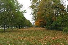
The Plympton Village Historic District encompasses the historic village center of Plympton, Massachusetts. It is a roughly linear district, running along Main Street (Massachusetts Route 58) between Palmer Road and Mayflower Road. There are twenty buildings in the district, most of which are residential. The focal point of the district, however, is the town green, around which the town's main civic buildings are arrayed. The green was laid out in 1702, but the oldest civic building (the First Congregational Church) was built in the 1850s, a period in which many of the houses were also built. The oldest building in the district is the Reverend Ezra Sampson House at 255 Main Street, which was built in the late 18th century.[2]
The district was listed on the National Register of Historic Places in 2007.[1]
See also
References
- 1 2 National Park Service (2008-04-15). "National Register Information System". National Register of Historic Places. National Park Service.
- ↑ "NRHP nomination for Plympton Village Historici District". Commonwealth of Massachusetts. Retrieved 2014-05-22.
| Topics |  | ||||||||||||||||||||||||||||||
|---|---|---|---|---|---|---|---|---|---|---|---|---|---|---|---|---|---|---|---|---|---|---|---|---|---|---|---|---|---|---|---|
| Lists by county | |||||||||||||||||||||||||||||||
| Lists by city |
| ||||||||||||||||||||||||||||||
| Other lists | |||||||||||||||||||||||||||||||
| |||||||||||||||||||||||||||||||