Pointe Coupee Parish, Louisiana
| Pointe Coupee Parish, Louisiana | |
|---|---|
|
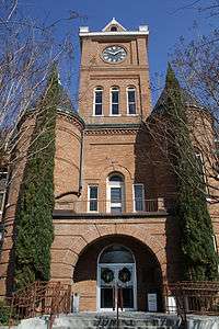
Pointe Coupee Parish Courthouse | |
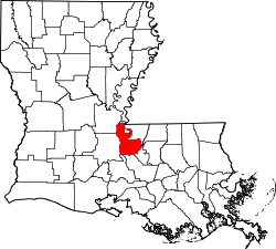 Location in the U.S. state of Louisiana | |
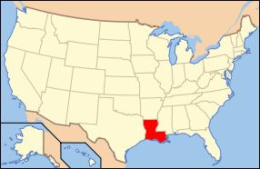 Louisiana's location in the U.S. | |
| Founded | 1807 |
| Named for | French for the place of the cut-off |
| Seat | New Roads |
| Largest city | New Roads |
| Area | |
| • Total | 591 sq mi (1,531 km2) |
| • Land | 557 sq mi (1,443 km2) |
| • Water | 33 sq mi (85 km2), 5.6% |
| Population | |
| • (2010) | 22,802 |
| • Density | 41/sq mi (16/km²) |
| Congressional district | 6th |
| Time zone | Central: UTC-6/-5 |
| Website |
www |
Pointe Coupee Parish, (pronounced /'pɔɪnt kə'pi:/; French: Paroisse de la Pointe-Coupée), is a parish located in the U.S. state of Louisiana. As of the 2010 census, the population was 22,802.[1] The parish seat is New Roads.[2]
Pointe Coupee Parish is part of the Baton Rouge, LA Metropolitan Statistical Area.
In 2010, the center of population of Louisiana was located in Pointe Coupee Parish, in the city of New Roads.[3]
History
Pointe Coupee Parish (originally pronounced pwant coo-pay) was organized by European Americans in 1805 as part of the Territory of Orleans (statehood for Louisiana followed in 1812). There were minor boundary adjustments with neighboring parishes up through 1852, when its boundaries stabilized.[4]
In 2008, Pointe Coupee was one of the communities that suffered the most damage by Hurricane Gustav.
Geography
According to the U.S. Census Bureau, the parish has a total area of 591 square miles (1,530 km2), of which 557 square miles (1,440 km2) is land and 33 square miles (85 km2) (5.6%) is water.[5] The land consists mainly of prairies and backswamp.
Major highways
Pointe Coupee Parish has 498.98 miles of highways within its borders.[6] U.S. Highway 190 is the only four-lane roadway in the parish[7][8]
-
 U.S. Highway 190
 -
 Louisiana Highway 1
 -
 Louisiana Highway 10
 -
 Louisiana Highway 15
 -
 Louisiana Highway 77
 -
 Louisiana Highway 78
 -
 Louisiana Highway 81
 -
 Louisiana Highway 411
 -
 Louisiana Highway 413
 -
 Louisiana Highway 414
 -
 Louisiana Highway 415
 -
 Louisiana Highway 416
 -
 Louisiana Highway 417
 -
 Louisiana Highway 418
 -
 Louisiana Highway 419
 -
 Louisiana Highway 420
 -
 Louisiana Highway 970
 -
 Louisiana Highway 971
 -
 Louisiana Highway 972
 -
 Louisiana Highway 973
 -
 Louisiana Highway 975
 -
 Louisiana Highway 976
 -
 Louisiana Highway 977
 -
 Louisiana Highway 978
 -
 Louisiana Highway 979
 -
 Louisiana Highway 981
 -
 Louisiana Highway 982
 -
 Louisiana Highway 983
 -
 Louisiana Highway 984
 -
 Louisiana Highway 3050
 -
 Louisiana Highway 3091
 -
 Louisiana Highway 3131
 -
 Louisiana Highway 3190
Major waterways
Adjacent parishes
- Concordia Parish (north)
- West Feliciana Parish (northeast)
- West Baton Rouge Parish (east)
- Iberville Parish (south)
- St. Martin Parish (southwest)
- St. Landry Parish (west)
- Avoyelles Parish (northwest)
National protected area
Demographics
| Historical population | ||||||||||||||||||||||||||||||||||||||||||||||||||||||||||||||||||||||||||||||||||
|---|---|---|---|---|---|---|---|---|---|---|---|---|---|---|---|---|---|---|---|---|---|---|---|---|---|---|---|---|---|---|---|---|---|---|---|---|---|---|---|---|---|---|---|---|---|---|---|---|---|---|---|---|---|---|---|---|---|---|---|---|---|---|---|---|---|---|---|---|---|---|---|---|---|---|---|---|---|---|---|---|---|---|
|
| |||||||||||||||||||||||||||||||||||||||||||||||||||||||||||||||||||||||||||||||||
| U.S. Decennial Census[9] 1790-1960[10] 1900-1990[11] 1990-2000[12] 2010-2013[1] Source: | ||||||||||||||||||||||||||||||||||||||||||||||||||||||||||||||||||||||||||||||||||
As of the census[14] of 2000, there were 22,763 people, 8,397 households, and 6,171 families residing in the parish. The population density was 41 people per square mile (16/km²). There were 10,297 housing units at an average density of 18 per square mile (7/km²). The racial makeup of the parish was 68.91% White, 29.61% Black or African American, 0.17% Native American, 0.25% Asian, 0.32% from other races, and 0.56% from two or more races. 1.08% of the population were Hispanic or Latino of any race. 93.61% of the population spoke only English at home, while 4.89% spoke French or Cajun French, 0.96% spoke Spanish, and 0.73% spoke Louisiana Creole French.
There were 8,397 households out of which 35.20% had children under the age of 18 living with them, 53.70% were married couples living together, 15.30% had a female householder with no husband present, and 26.50% were non-families. 23.40% of all households were made up of individuals and 11.10% had someone living alone who was 65 years of age or older. The average household size was 2.67 and the average family size was 3.17.
In the parish the population was spread out with 27.30% under the age of 18, 8.80% from 18 to 24, 27.00% from 25 to 44, 23.10% from 45 to 64, and 13.90% who were 65 years of age or older. The median age was 37 years. For every 100 females there were 94.40 males. For every 100 females age 18 and over, there were 90.70 males.
The median income for a household in the parish was $30,618, and the median income for a family was $36,625. Males had a median income of $35,022 versus $20,759 for females. The per capita income for the parish was $15,387, ranking 23rd out of 64 parishes. About 18.70% of families and 23.10% of the population were below the poverty line, including 30.20% of those under age 18 and 23.90% are the age of 65 and older.
Economy
Nan Ya Plastics Corporation America has a large plant near Batchelor, Louisiana. NRG / Big Cajun 1 & 2 power plants near New Roads, LA
Education
Schools
The Pointe Coupee Parish School Board serves the parish.
As of 2014 the sole secondary school operated by the parish school board is Livonia High School, serving grades 7 through 12. Pointe Coupee Central High School was closed down in 2014.
Private
National Guard
A Co of the 769th BEB (Brigade Engineer Battalion) is an Engineer Company (Combat) that resides in New Roads, Louisiana. This unit is part of the 256TH IBCT and deployed to Iraq in 2004-5 and 2010.
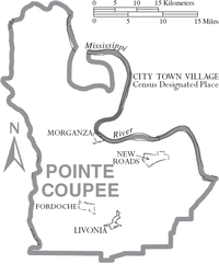
Communities
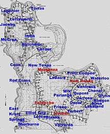
City
- New Roads (parish seat)
Towns
Village
Census-designated place
Unincorporated communities
|
|
|
|
Notable residents
- Lindy Boggs (1916-2013) – U.S. Representative from Louisiana's 2nd congressional district and U.S. Ambassador to the Holy See
- Emmitt Douglas (1926–1981) – president of the Louisiana NAACP from 1966–1981, resided in New Roads from 1949–1981
- Ernest Gaines – author
- Clark Gaudin - former state representative from East Baton Rouge Parish
- Buddy Guy - Singer
- Gwendolyn Midlo Hall, historian, did extensive research and writing about slavery in Louisiana, having discovered important documentation of the slave trade and individual slaves that provided new understanding of African-American history in Louisiana, including the specific ethnic origins in various African cultures of many slaves
- Russel L. Honoré - retired Lieutenant General, U.S. Army
- J. Thomas Jewell - state representative 1936-1968; Speaker of the Louisiana House 1960-1964
- J. E. Jumonville, Jr. - state senator from District 17, 1976-1992, horse breeder
- J. E. Jumonville, Sr. - state senator, 1968-1976, natural gas developer
- Catherine D. Kimball - former Chief Justice of Louisiana Supreme Court; former judge of the Louisiana 18th Judicial District Court, 1983-1993
- Clyde Kimball, state representative for Pointe Coupee and West Baton Rouge parishes, 1976-1992
- Major General John Archer Lejeune, career military officer and Commandant of the United States Marine Corps.
- Hall Lyons (1923-1998) - Louisiana oilman and politician, owned at least two oil wells in Pointe Coupee Parish.
- deLesseps Story Morrison (1912–1964), born in New Roads, was elected four times as mayor of New Orleans, serving from 1946 to 1962; he ran unsuccessfully three times for governor of Louisiana. He was also the United States ambassador to the Organization of American States.
- Jacob Haight Morrison, (1905-1974), New Roads native, became a journalist, politician and preservationist, helping protect the French Quarter of New Orleans.
- Charles Parlange - former Chief Justice of Louisiana Supreme Court
- Julien Poydras – territorial U.S. Representative for Louisiana; 1st State Senate President, philanthropist
- James Ryder Randall - poet, teacher at Poydras Academy, 1856–1860, wrote "Maryland, My Maryland" while living in Pointe Coupée Parish
- Nauman Scott - judge of the United States District Court for the Western District of Louisiana, based in Alexandria
- Major Thibaut - state representative for District 18 since 2008; New Roads businessman
- Chris Williams - offensive tackle for the St. Louis Rams
- Clyde Kimball - former State Representative and former deputy secretary of the Louisiana Department of Wildlife and Fisheries
See also
- National Register of Historic Places listings in Pointe Coupee Parish, Louisiana
- Pointe Coupee Parish Sheriff's Office
References
- 1 2 "State & County QuickFacts". United States Census Bureau. Retrieved August 18, 2013.
- ↑ "Find a County". National Association of Counties. Retrieved 2011-06-07.
- ↑ "Centers of Population by State: 2010". United States Census Bureau. Retrieved September 1, 2014.
- ↑ Gold Bug Software. "AniMap Plus: County Boundary Historical Atlas".
- ↑ "2010 Census Gazetteer Files". United States Census Bureau. August 22, 2012. Retrieved August 20, 2014.
- ↑ "Louisiana State Police". lsp.org.
- ↑ "Please redirect your browser to the new URL on AARoads". southeastroads.com.
- ↑ http://www.pcpolicejury.org/econdev/profile/transportation.html
- ↑ "U.S. Decennial Census". United States Census Bureau. Retrieved August 20, 2014.
- ↑ "Historical Census Browser". University of Virginia Library. Retrieved August 20, 2014.
- ↑ "Population of Counties by Decennial Census: 1900 to 1990". United States Census Bureau. Retrieved August 20, 2014.
- ↑ "Census 2000 PHC-T-4. Ranking Tables for Counties: 1990 and 2000" (PDF). United States Census Bureau. Retrieved August 20, 2014.
- ↑ "Census of Population and Housing". Census.gov. Retrieved June 4, 2015.
- ↑ "American FactFinder". United States Census Bureau. Retrieved 2008-01-31.
External links
| Wikimedia Commons has media related to Pointe Coupee Parish, Louisiana. |
- Pointe Coupee Interactive Map
- Official Pointe Coupee Parish website
- Gwendolyn Midlo Hall, "THE LOUISIANA SLAVE DATABASE AND THE LOUISIANA FREE DATABASE: 1719-1820", iBiblio website
- Official Pointe Coupee Parish Sheriff's Office website
- Explore the History and Culture of Southeastern Louisiana, a National Park Service Discover Our Shared Heritage Travel Itinerary
- Pointe Coupee at the Millennium Documentary Photography Project
 |
Avoyelles Parish | Concordia Parish | West Feliciana Parish | |
| St. Landry Parish | |
West Baton Rouge Parish | ||
| ||||
| | ||||
| St. Martin Parish | Iberville Parish |
Municipalities and communities of Pointe Coupee Parish, Louisiana, United States | ||
|---|---|---|
| City | | |
| Towns | ||
| Village | ||
| CDP | ||
| Other unincorporated communities | ||
| Ghost towns | ||
Coordinates: 30°43′N 91°36′W / 30.71°N 91.60°W