Polje District
This article is about the Polje District. For the former village of Polje, see Polje, Ljubljana.
| Polje District Četrtna skupnost Polje | |
|---|---|
| District | |
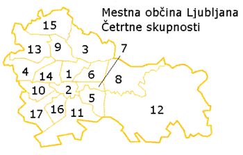 Map of districts in Ljubljana. The Polje District is number 8. | |
 Polje District Location in Slovenia | |
| Coordinates: 46°3′28.69″N 14°35′0.52″E / 46.0579694°N 14.5834778°ECoordinates: 46°3′28.69″N 14°35′0.52″E / 46.0579694°N 14.5834778°E | |
| Country |
|
| Traditional region | Upper Carniola |
| Statistical region | Central Slovenia |
| Municipality | Ljubljana |
| Area[1] | |
| • Total | 22.10 km2 (8.53 sq mi) |
| Population (2014)[1] | |
| • Total | 19,433 |
The Polje District (pronounced [ˈpoːljɛ]; Slovene: Četrtna skupnost Polje), or simply Polje, is a district (mestna četrt) of the City Municipality of Ljubljana, the capital of Slovenia. It is named after the former village of Polje.
Geography
The Polje District is bounded on the west by the A1 Freeway, on the north by the Sava River, and on the east and south by the Ljubljanica River. The district includes the former villages of Polje, Slape, Spodnja Zadobrova, Spodnji Kašelj, Vevče, Zalog, Zgornja Zadobrova, and Zgornji Kašelj.
References
| Wikimedia Commons has media related to Polje, Ljubljana. |
- 1 2 City of Ljubljana Districts (Slovene)
External links
This article is issued from Wikipedia - version of the 8/31/2015. The text is available under the Creative Commons Attribution/Share Alike but additional terms may apply for the media files.