Pont De Rennes bridge
| Pont De Rennes Bridge | |
|---|---|
 | |
| Coordinates | 43°09′46″N 77°36′55″W / 43.162756°N 77.615394°WCoordinates: 43°09′46″N 77°36′55″W / 43.162756°N 77.615394°W |
| Carries | Pedestrians and bicycles |
| Crosses | Genesee River |
| Locale | Rochester New York |
| Characteristics | |
| Design | Truss bridge |
| Material | Steel |
| Total length | 858 ft |
| History | |
| Designer | Leffert L. Buck |
| Opened | 1891 |
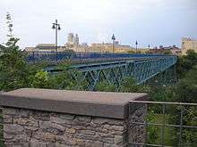
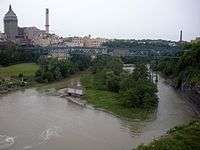
The Pont De Rennes bridge is located in the Brown's Race Historic District of Rochester New York at the base of the High Falls where it spans the Genesee River. The Pont De Rennes bridge formerly carried Platt Street [1] over the river but was converted to pedestrian use in 1982 as part of a redevelopment of the High Falls area as an entertainment area. The bridge was renamed the Pont De Rennes for Rochester's sister city Rennes in France as part of the conversion. The Pont De Rennes bridge provides unobstructed views of the High Falls and downstream gorge.[2]
View of the bridge from the north bank
The bridge was designed by Leffert Buck, who also designed the Williamsburg Bridge in New York City.[3]
References
This article is issued from Wikipedia - version of the 12/23/2014. The text is available under the Creative Commons Attribution/Share Alike but additional terms may apply for the media files.