Port Allen, Louisiana
| City of Port Allen | |
| Named for Henry Watkins Allen | |
| City | |
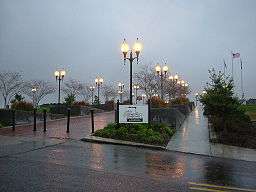 The Old Ferry Landing at Port Allen | |
| Country | United States |
|---|---|
| State | Louisiana |
| Parish | West Baton Rouge |
| Elevation | 26 ft (7.9 m) |
| Coordinates | 30°27′13″N 91°12′36″W / 30.45361°N 91.21000°WCoordinates: 30°27′13″N 91°12′36″W / 30.45361°N 91.21000°W |
| Area | 2.6 sq mi (6.7 km2) |
| - land | 2.1 sq mi (5 km2) |
| - water | 0.5 sq mi (1 km2), 19.23% |
| Population | 5,180 (2010) |
| Density | 2,486.3/sq mi (960.0/km2) |
| Incorporated | 1916 |
| Mayor | Demetric "Deedy" Slaughter (elected 2012; recalled 2013)[1] Lynn Robertson (mayor from 1993 to 2004 and in the interim from December 2013 to May 2014)[2] Richard N. Lee, III (D) (elected April 5, 2014) |
| Timezone | CST (UTC-6) |
| - summer (DST) | CDT (UTC-5) |
| Area code | 225 |
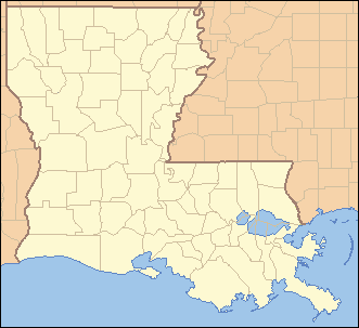 Location of Port Allen in Louisiana | |
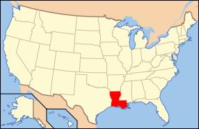 Location of Louisiana in the United States | |
| Website: http://www.portallen.org | |
Port Allen is a city in and the parish seat of West Baton Rouge Parish, Louisiana, United States.[3] Port Allen is located between Interstate 10 and US Highway 190 on the West bank of the Mississippi River. The population was 5,180 at the 2010 census. It is part of the Baton Rouge Metropolitan Statistical Area.
Port Allen is home to the Mississippi Riverfront Development which provides a panoramic view of the Mississippi River and Baton Rouge, the West Baton Rouge Museum, the City of Port Allen Railroad Depot, Scott's Cemetery, the Port of Greater Baton Rouge, the Port Allen Lock.
Port Allen is named for Governor Henry Watkins Allen.
Government
The City of Port Allen was incorporated in 1916 and operates under the Lawrason Act[4] form of government. The Mayor is elected at large. The elected Mayor is the City's chief executive officer and responsible for the daily activities and services of the City. The Mayor's office includes the Chief Administrative Officer and the Chief Financial Officer. There are five City Council members with four members elected in districts and one member elected at large. The Council writes policies, adopts ordinances and resolutions, and appoints members to boards and commissions.
Registered Historical Places
The registered historical places in Port Allen include: Aillet House, Allendale Plantation Historic District, Cohn High School, Monte Vista Plantation House, Poplar Grove Plantation House, Port Allen Middle School, Sandbar Plantation House, and the Smithfield Plantation House.
Festivals
Port Allen Festivals include the Lagniappe Dulcimer Fete Festival, Port Allen Bonfires on the Mississippi River, SugarFest, West Baton Rouge Parish Fair, and the Oldies but Goodies Fest.
Attractions
The West Baton Rouge Museum includes the museum, the c. 1830 Aillet House, a c. 1870s Reconstruction Era worker's cabin, and a c. 1890s cabin decorated to look as it would have during the Civil Rights Era), the c. 1880s Arbroth Plantation Store, the c. 1938 Reed Farm and Ranch Shotgun House, and a reproduction early 20th century barn.[5]
The City of Port Allen Railroad Depot is a museum depicting the life of railroad workers in the 1940s. It includes a ticket booth, clothing and memorabilia from that era, along with the typewriter originally used at the depot. The 1950 caboose, which is also open for tours, is the only one in Louisiana that is almost totally restored to its original condition.
The Mississippi Riverfront Development offers a panoramic view of the Mighty Mississippi and Baton Rouge. The area includes a pedestrian promenade with special architectural paving, viewing benches, and ornamental street lighting. On this site a ferry operated between Port Allen and Baton Rouge from 1820 to 1968.
Scott’s Cemetery is the burial place of African Americans in West Baton Rouge's history and dates back to the 1850s. It is located at the corner of Court and Commerce Streets near the Riverfront Development.
The Port of Greater Baton Rouge, located in Port Allen, is the head of deepwater navigation on the Mississippi River, serving barges and ocean-going vessels with international import and export facilities for all types of cargo, from grain to paper products, chemicals, manufactured goods, bulk ores and petroleum products. It is one of the top ten ports in the country. It handles roughly 61 million short tons of cargo each year, has 3,000 feet (910 m) of dock and 550,000 square feet (51,000 m2) of warehouse space. Its facilities include grain elevator storage, molasses, sugar, oil and coffee terminals.
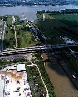
The Port Allen Lock connects the Mississippi River to the Gulf Intracoastal Waterway, shortening the distance to the Gulf of Mexico by approximately 120 miles (190 km). The Lock, a free-floating structure is the largest of its kind, as it serves as a man-made break in the levee. The massive structure has 90-ton doors and 64 feet (20 m) sides. The lock was constructed in 1961 by the U.S. Army Corps of Engineers to replace the historic Plaquemine Lock. The Intracoastal Waterway is an east-west inland waterway shortcut that connects Florida and Texas, eliminating 130 miles (210 km) of shipping distance.
Geography
Port Allen is located at 30°27′13″N 91°12′36″W / 30.45361°N 91.21000°W (30.453740, -91.209957).[6]
According to the United States Census Bureau, the city has a total area of 2.6 square miles (6.8 km²), of which, 2.1 square miles (5.5 km²) of it is land and 0.5 square miles (1.3 km²) of it (19.39%) is water.
Demographics
| Historical population | |||
|---|---|---|---|
| Census | Pop. | %± | |
| 1920 | 920 | — | |
| 1930 | 1,524 | 65.7% | |
| 1940 | 1,898 | 24.5% | |
| 1950 | 3,097 | 63.2% | |
| 1960 | 5,026 | 62.3% | |
| 1970 | 5,728 | 14.0% | |
| 1980 | 6,114 | 6.7% | |
| 1990 | 6,277 | 2.7% | |
| 2000 | 5,278 | −15.9% | |
| 2010 | 5,180 | −1.9% | |
| Est. 2015 | 5,130 | [7] | −1.0% |
2011 estimate[9] | |||
As of the census of 2000, there were 5,278 people, 2,012 households, and 1,416 families residing in the city. The population density was 2,486.3 people per square mile (961.2/km²). There were 2,158 housing units at an average density of 1,016.6 per square mile (393.0/km²). The racial makeup of the city was 45.04% White, 53.98% African American, 0.15% Native American, 0.04% Asian, 0.02% Pacific Islander, 0.27% from other races, and 0.51% from two or more races. Hispanic or Latino of any race were 1.00% of the population.
There were 2,012 households out of which 30.5% had children under the age of 18 living with them, 39.7% were married couples living together, 25.7% had a female householder with no husband present, and 29.6% were non-families. 26.2% of all households were made up of individuals and 9.2% had someone living alone who was 65 years of age or older. The average household size was 2.56 and the average family size was 3.09.
In the city the population was spread out with 25.5% under the age of 18, 10.1% from 18 to 24, 26.4% from 25 to 44, 22.9% from 45 to 64, and 15.1% who were 65 years of age or older. The median age was 37 years. For every 100 females there were 84.7 males. For every 100 females age 18 and over, there were 80.1 males.
The median income for a household in the city was $30,254, and the median income for a family was $36,762. Males had a median income of $31,029 versus $22,333 for females. The per capita income for the city was $14,439. About 19.2% of families and 24.2% of the population were below the poverty line, including 34.4% of those under age 18 and 8.5% of those age 65 or over.
Notable people
Port Allen is the hometown of Tracy Porter, currently a cornerback for the Chicago Bears, who played for the New Orleans Saints in 2009, and clinched the Saints' win in Super Bowl XLIV with his late fourth quarter interception of a pass by Indianapolis Colts quarterback Peyton Manning. In the aftermath of the Super Bowl win, Port Allen first jokingly renamed the city "Porter Allen" for a day in Porter's honor,[10][11] then later named a street after him.[12]
Arthur T. Prescott, educator who was founding president of Louisiana Tech University in 1894, taught school in Port Allen from 1883–1884.[13]
State Senator Rick Ward, III, of District 17 practices law in Port Allen but resides in his native Iberville Parish.[14] In July 2013, he switched from Democratic to Republican affiliation.[15]
See also
References
- ↑ http://www.nola.com/news/baton-rouge/index.ssf/2013/11/port_allen_voters_recall_mayor.html
- ↑ "Terry L. Jones, Jindal taps Lynn Robertson as Port Allen's interim mayor, December 17, 2013". Baton Rouge Morning Advocate. Retrieved December 18, 2013.
- ↑ "Find a County". National Association of Counties. Retrieved 2011-06-07.
- ↑ Lawrason Act
- ↑ http://westbatonrougemuseum.com/index.php?option=com_k2&view=itemlist&layout=category&task=category&id=26&Itemid=76
- ↑ "US Gazetteer files: 2010, 2000, and 1990". United States Census Bureau. 2011-02-12. Retrieved 2011-04-23.
- ↑ "Annual Estimates of the Resident Population for Incorporated Places: April 1, 2010 to July 1, 2015". Retrieved July 2, 2016.
- ↑ United States Census Bureau. "CENSUS OF POPULATION AND HOUSING". Retrieved January 14, 2012.
- ↑ United States Census Bureau. "Table 3. Annual Estimates of the Resident Population for Incorporated Places in Louisiana: April 1, 2010 to July 1, 2011 (SUB-EST2011-03-22)". Retrieved January 14, 2012.
- ↑ Tyana Williams, "City changes its name to Porter Allen", WAFB, February 8, 2010.
- ↑ Bradley Handwerger, "Saints CB Porter enjoying the moment, but ready to get back with teammates", WWL-TV, March 31, 2010.
- ↑ Koran Addo, "Port Allen renames street to honor Porter", Baton Rouge Morning Advocate (Baton Rouge, La.), April 20, 2010.
- ↑ Henry E. Chambers, A History of Louisiana, Vol. 2 (Chicago and New York City: American Historical Society, 1925), pp. 313-314
- ↑ "Senator Rick Ward, III". labi.org. Retrieved July 17, 2013.
- ↑ "State senator Rick Ward III switches parties". Baton Rouge Morning Advocate. Retrieved July 17, 2013.
External links
| Wikimedia Commons has media related to Port Allen, Louisiana. |
Municipalities and communities of West Baton Rouge Parish, Louisiana, United States | ||
|---|---|---|
| City | 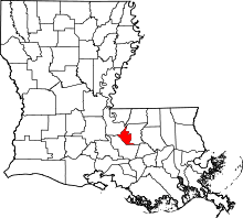 | |
| Towns | ||
| CDP | ||
| Unincorporated community | ||