Port Huron, Michigan
| Port Huron, Michigan | |
|---|---|
| City | |
|
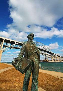
Young Thomas Edison, in front of the Blue Water Bridge | |
| Nickname(s): Maritime Capital of the Great Lakes, Gateway to Canada | |
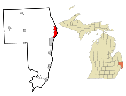 Location within St. Clair county (left) and Michigan (right) | |
| Coordinates: 42°58′49″N 82°26′15″W / 42.98028°N 82.43750°WCoordinates: 42°58′49″N 82°26′15″W / 42.98028°N 82.43750°W | |
| Country | United States |
| State | Michigan |
| County | St. Clair |
| Incorporated | 1857 |
| Government | |
| • Type | Council-Manager |
| • Mayor | Pauline Repp |
| Area[1] | |
| • Total | 12.26 sq mi (31.75 km2) |
| • Land | 8.08 sq mi (20.93 km2) |
| • Water | 4.18 sq mi (10.83 km2) |
| Elevation | 604 ft (184 m) |
| Population (2010)[2] | |
| • Total | 30,184 |
| • Estimate (2012[3]) | 29,684 |
| • Density | 2,500/sq mi (950/km2) |
| Time zone | Eastern (EST) (UTC−5) |
| • Summer (DST) | EDT (UTC−4) |
| ZIP code | 48060 |
| Area code | 810 |
| FIPS code | 26-65820 [4] |
| GNIS feature ID | 1624839 [5] |
| Website | porthuron.org |
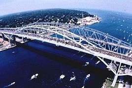
Port Huron is a city in the U.S. state of Michigan and the county seat of St. Clair County.[6] The population was 30,184 at the 2010 census. The city is adjacent to Port Huron Township but is administratively autonomous. Located along the St. Clair River, it is connected to Point Edward, Ontario in Canada via the Blue Water Bridge. The city lies at the southern end of Lake Huron and is the easternmost point on land in Michigan. Port Huron is home to two paper mills; Mueller brass; and many businesses related to tourism and the automotive industry. The city features a historic downtown area, boardwalk, marina, museum, lighthouse, and the McMorran Place arena and entertainment complex.
History
In 1814 following the War of 1812, the United States established Fort Gratiot at the base of Lake Huron. French colonists had a temporary trading post and fort at this site in the 17th century, but this developed as the first settled European-American population in the area. Until 1836, an Ojibwa reservation occupied land in part of the modern area of Port Huron. They were removed to west of the Mississippi in Wisconsin and Minnesota.[7]
In 1857, Port Huron became incorporated. Its population grew rapidly after the 1850s due a high rate of immigration attracted by the successful shipbuilding and lumber trade. In 1859 the city had a total of 4.031 residents; 1855 were of foreign birth or their children.[8] By 1870, Port Huron's population exceeded that of surrounding villages. In 1871, the State Supreme Court designated Port Huron as the county seat.[9]
On October 8, 1871, the city, as well as places north in Sanilac and Huron counties, burned in the Port Huron Fire of 1871. A series of other fires leveled Holland and Manistee, Michigan, as well as Peshtigo, Wisconsin and Chicago on the same day. The Thumb Fire that occurred a decade later, also engulfed Port Huron.
In 1895 the village of Fort Gratiot, in the vicinity of the former Fort Gratiot, was annexed by the city of Port Huron.[10]
The following historic sites have been recognized by the State of Michigan through its historic marker program.
- Fort St. Joseph. The fort was built in 1686 by the French explorer Duluth. This fort was the second European settlement in lower Michigan. This post guarded the upper end of the St. Clair River, the vital waterway joining Lake Erie and Lake Huron. Intended by the French to bar English traders from the upper lakes, the fort in 1687 was the base of a garrison of French and Indians. In 1688 the French abandoned this fort. The site was incorporated into Fort Gratiot in 1814. A park has been established at the former site of the fort.
- Fort Gratiot Light. The Fort Gratiot Lighthouse was built in 1829 to replace a tower destroyed by a storm. In the 1860s workers extended the tower to its present height of 84 feet (26 m). The light, automated in 1933, continues to guide shipping on Lake Huron into the narrow and swift-flowing St. Clair River. It was the first lighthouse established in the State of Michigan.
- Lightship Huron. From 1935 until 1970, the Huron was stationed in southern Lake Huron to mark dangerous shoals. After 1940 the Huron was the only lightship operating on the Great Lakes. Retired from Coast Guard Service in 1970, she was presented to the City of Port Huron in 1971.
- Grand Trunk Railway Depot. The depot, which is now part of the Port Huron Museum, is where 12-year-old Thomas Edison departed daily on the Port Huron – Detroit run. In 1859, the railroad's first year of operation, Edison convinced the railroad company to let him sell newspapers and confections on the daily trips. He became so successful that he soon placed two newsboys on other Grand Trunks running to Detroit. He made enough money to support himself and to buy chemicals and other experimental materials.
- Port Huron Public Library. In 1902 the city of Port Huron secured money from philanthropist Andrew Carnegie to erect a municipal library. In 1904, a grand Beaux-Arts-style structure was built at a cost of $45,000. At its dedication, Melvil Dewey, creator of a widely used book classification system, delivered the opening address. The Port Huron Public Library served in its original capacity for over sixty years. In 1967, a larger public library was constructed. The following year the former library was renovated and re-opened as the Port Huron Museum of Arts and History. An addition was constructed in 1988.
- Harrington Hotel. The Hotel opened in 1896 and is a blend of Romanesque, Classical and Queen Anne architecture. The hotel closed in 1986, but a group of investors bought the structure that same year to convert it into housing for senior citizens. The Harrington Hotel is listed on the National Register of Historic Places.
- Grand Trunk Western Railroad Tunnel. The tunnel was opened in 1891 and links Port Huron with Canada. This international submarine railway tunnel was the first international tunnel in the world. The tunnel's total length is 6,025 feet (1,836 m), with 2,290 feet (700 m) underwater. The tunnel operations were electrified in 1908; half a century later they were converted to use diesel fuel. Tracks were lowered in 1949 to accommodate larger freight cars. During World War I, a plot to blast the tunnel was foiled. A new tunnel has since been opened.
In 1962, a convention of the Students for a Democratic Society was held in Lakeport, a community several miles north of the city. While there, they developed the Port Huron Statement, the SDS manifesto.
The city received the All-America City Award in 1955 and 2005.
Historic photographs
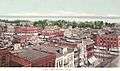 Port Huron circa 1902
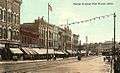 Huron Avenue in 1912
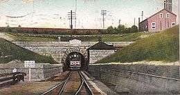 St. Clair Tunnel in 1907
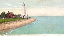 Gratiot Lighthouse in 1902
.jpg)
Geography
- According to the United States Census Bureau, the city has a total area of 12.26 square miles (31.75 km2), of which 8.08 square miles (20.93 km2) is land and 4.18 square miles (10.83 km2) is water.[1]
- It is considered to be part of the Thumb area of Mid Michigan, and Southeast Michigan. St. Clair county is part of the Detroit Metropolitan Statistical area.
- Port Huron is the principal city of the region known as Blue Water Area, a subregion of the Thumb.
- The easternmost point (on land) of Michigan can be found in Port Huron, just south of the Blue Water Bridge.
Climate
| Climate data for Port Huron NOAA Station | |||||||||||||
|---|---|---|---|---|---|---|---|---|---|---|---|---|---|
| Month | Jan | Feb | Mar | Apr | May | Jun | Jul | Aug | Sep | Oct | Nov | Dec | Year |
| Record high °F (°C) | 64 (18) |
69 (21) |
82 (28) |
87 (31) |
96 (36) |
102 (39) |
103 (39) |
102 (39) |
101 (38) |
90 (32) |
81 (27) |
66 (19) |
103 (39) |
| Average high °F (°C) | 31.3 (−0.4) |
33.8 (1) |
42.8 (6) |
55.5 (13.1) |
67.1 (19.5) |
77.3 (25.2) |
82.0 (27.8) |
80.5 (26.9) |
73.4 (23) |
60.6 (15.9) |
47.7 (8.7) |
35.6 (2) |
57.3 (14.1) |
| Daily mean °F (°C) | 24.3 (−4.3) |
26.2 (−3.2) |
34.4 (1.3) |
45.9 (7.7) |
56.9 (13.8) |
66.9 (19.4) |
72.3 (22.4) |
71.2 (21.8) |
63.8 (17.7) |
51.7 (10.9) |
40.5 (4.7) |
29.2 (−1.6) |
48.61 (9.22) |
| Average low °F (°C) | 17.4 (−8.1) |
18.6 (−7.4) |
26.0 (−3.3) |
36.2 (2.3) |
46.6 (8.1) |
56.6 (13.7) |
62.6 (17) |
61.8 (16.6) |
54.3 (12.4) |
42.7 (5.9) |
33.3 (0.7) |
22.8 (−5.1) |
39.9 (4.4) |
| Record low °F (°C) | −19 (−28) |
−26 (−32) |
−7 (−22) |
8 (−13) |
21 (−6) |
32 (0) |
35 (2) |
37 (3) |
25 (−4) |
20 (−7) |
2 (−17) |
−7 (−22) |
−26 (−32) |
| Average precipitation inches (mm) | 1.96 (49.8) |
1.97 (50) |
2.07 (52.6) |
2.86 (72.6) |
3.13 (79.5) |
3.39 (86.1) |
3.23 (82) |
3.26 (82.8) |
3.84 (97.5) |
2.78 (70.6) |
3.11 (79) |
2.19 (55.6) |
33.78 (858) |
| Average snowfall inches (cm) | 11.0 (27.9) |
9.9 (25.1) |
5.0 (12.7) |
0.7 (1.8) |
0 (0) |
0 (0) |
0 (0) |
0 (0) |
0 (0) |
0 (0) |
1.3 (3.3) |
8.3 (21.1) |
36.1 (91.7) |
| Average precipitation days (≥ 0.01 in) | 13.0 | 10.0 | 10.5 | 12.9 | 11.7 | 10.7 | 10.1 | 10.7 | 10.8 | 11.9 | 12.5 | 13.4 | 138.2 |
| Average snowy days (≥ 0.1 in) | 7.4 | 5.9 | 2.9 | 0.6 | 0 | 0 | 0 | 0 | 0 | 0 | 0.8 | 5.3 | 22.9 |
| Source: NOAA [11] | |||||||||||||
Demographics
| Historical population | |||
|---|---|---|---|
| Census | Pop. | %± | |
| 1860 | 4,371 | — | |
| 1870 | 5,973 | 36.7% | |
| 1880 | 8,883 | 48.7% | |
| 1890 | 13,543 | 52.5% | |
| 1900 | 19,158 | 41.5% | |
| 1910 | 18,863 | −1.5% | |
| 1920 | 25,944 | 37.5% | |
| 1930 | 31,361 | 20.9% | |
| 1940 | 32,759 | 4.5% | |
| 1950 | 35,725 | 9.1% | |
| 1960 | 36,084 | 1.0% | |
| 1970 | 35,794 | −0.8% | |
| 1980 | 33,981 | −5.1% | |
| 1990 | 33,694 | −0.8% | |
| 2000 | 32,338 | −4.0% | |
| 2010 | 30,184 | −6.7% | |
| Est. 2015 | 29,330 | [12] | −2.8% |
Port Huron is the largest city in the Thumb area, and is a center of industry and trade for the region.
2010 census
As of the census[2] of 2010, there were 30,184 people, 12,177 households, and 7,311 families residing in the city. The population density was 3,735.6 inhabitants per square mile (1,442.3/km2). There were 13,871 housing units at an average density of 1,716.7 per square mile (662.8/km2). The racial makeup of the city was 84.0% White, 9.1% African American, 0.7% Native American, 0.6% Asian, 1.2% from other races, and 4.5% from two or more races. Hispanic or Latino of any race were 5.4% of the population.
There were 12,177 households of which 32.5% had children under the age of 18 living with them, 34.5% were married couples living together, 19.9% had a female householder with no husband present, 5.6% had a male householder with no wife present, and 40.0% were non-families. 33.0% of all households were made up of individuals and 11.8% had someone living alone who was 65 years of age or older. The average household size was 2.42 and the average family size was 3.03.
The median age in the city was 35.8 years. 25.6% of residents were under the age of 18; 9.9% were between the ages of 18 and 24; 26.3% were from 25 to 44; 25.2% were from 45 to 64; and 13.1% were 65 years of age or older. The gender makeup of the city was 47.8% male and 52.2% female.
Culture
.jpg)
- There are a number of museums in town. The Port Huron Museum is a series of four museums,[14] namely:
- The Great Lakes Maritime Center offers a lot of opportunities to learn about the history of the Great Lakes. Freighters pass within 100' of the wide glass windows, and there is an underwater live camera feed.
- The School for Strings presents over 50 concerts each year with its Fiddle Club, Faculty and Student Ensembles. It provides a premier music education across the area with more than half its graduates going on to professional studies in major music school across the country.
- There are a number of recurring local events. A calendar is available.[16]
- Each year, the Port Huron to Mackinac Boat Race is held, with a starting point in Port Huron north of the Blue Water Bridge. The race finishes at Mackinac Island, Michigan, crossing Lake Huron. It is considered by some boaters to be a companion to the longer Chicago Yacht Club Race to Mackinac.
- The Port Huron Civic Theatre began in 1956 by a group of theater lovers. Since 1983, it has used McMorran Place for its productions.
- The fall brings the Blue Water Film Festival. Which has had notables such as Chris Gore, Sid Haig, Curtis Armstrong, Timothy Busfield, Loni Love, Dave Coulier and more.
- The main branch of the St. Clair County Library is located in downtown Port Huron. The library contains more than 285,300 books, nearly 200 magazine subscriptions, and over 22,700 books on tape, books on compact disc, music compact discs, cassettes, and videos.
- The International Symphony Orchestra of Sarnia, Ontario and Port Huron, Michigan perform events at McMorran Place and the Imperial Oil Centre for the Performing Arts in Sarnia.
- Encompassing over 100 homes and buildings, the Olde Town Historic District is Port Huron's first and only residential historic district. The Olde Town Historic Neighborhood Association is an organization working to preserve historic architecture in Port Huron. They have hosted an annual historic home tour, flower plantings and beautification and neighborhood Christmas decorations.
- The Welkin Base Ball Club is Port Huron's historic vintage base ball team. Modeled on Port Huron's first baseball club from 1867, the Welkin Base Ball Club re-creates the time of base ball's roots. Playing other vintage ball clubs of the area, the Welkins strive to entertain and educate spectators about Port Huron's past.
Sports
Port Huron has had a strong tradition of minor league hockey for many years.
The Port Huron Flags played in the original International Hockey League from 1962-1981, winning three Turner Cup championships in 1966, 1971 and 1972. Its leading career scorers were Ken Gribbons, who played most of his career in the IHL; Bob McCammon, a lifelong IHLer who went on to be a National Hockey League coach with the Philadelphia Flyers and the Vancouver Canucks; Bill LeCaine and Larry Gould, who played a handful of NHL games with the Pittsburgh Penguins and the Vancouver Canucks, respectively.
Port Huron was also represented in the Colonial Hockey League (also operating under the names United Hockey League and International Hockey League), with franchises from 1996 until the league folded in 2010. Originally called the Border Cats, the team was renamed the Beacons in 2002, the Flags in 2005 and the Icehawks in 2007. Among the more notable players were Bob McKillop, Jason Firth, Tab Lardner and Brent Gretzky.
The Port Huron Fighting Falcons of the junior North American Hockey League played at McMorran Place, beginning in 2010 until 2013. The team moved to Connellsville, PA for the 2014 season. The team's name was changed to the Keystone Ice Miners.
Port Huron is also home to the Port Huron Prowlers of the Federal Hockey League.
The Port Huron Pirates indoor football team dominated the Great Lakes Indoor Football League up until their departure to Flint, MI. McMorran Arena once again hosted indoor football with the Port Huron Predators of the Continental Indoor Football League in 2011. The Predators failed to finish the 2011 season, and were replaced in 2012 by the Port Huron Patriots who also particiate in the CIFL.
Parks
The City of Port Huron owns and operates 17 waterfront areas containing 102 acres (0.4 km2) and 3.5 miles (5.6 km) of water frontage. This includes three public beaches and six parks with picnic facilities. The city also has nine scenic turnout sites containing over 250 parking spaces. Port Huron operates the largest municipal marina system in the state and has five separate locations for boat mooring.
The City has 14 public parks, 4 smaller-sized “tot” parks, 19 playgrounds (City owned), 9 playgrounds (School owned), 33 tennis courts, including 16 at schools and 6 indoors, 3 public beaches, 4 public swimming pools, 1 community center, and 1 public parkway.
Government
The city government is organized under a council/manager form of government. The City Council is responsible for appointing a City Manager, who is the Chief Administrative Officer of the city. The Manager supervises the administrative affairs of the city and carries out the policies established by the City Council. As the Chief Administrative Officer, the City Manager is responsible for the organization of the administrative branch and has the power to appoint and remove administrative officers who are responsible for the operation of departments which carry out specific functions. The City Council consists of seven elected officials—a mayor and six council members. Beginning with the 2011 election, citizens will vote separately for Mayor and Council. Council members will serve staggered four-year terms and the Mayor will serve a two-year term. The current mayor is former city clerk, Pauline Repp.
Federally, Port Huron is part of Michigan's 10th congressional district, represented by Republican Candice Miller, elected in 2002.
Education
- Colleges
- St. Clair County Community College
- Baker College - Port Huron Campus
Media
Radio
The thumb area is an unranked radio market with two commercial broadcasters licensed to serve the city. Radio First owns and operates five radio stations in the region while Port Huron Family Radio is the licensee of sole station WGRT.
The following is a list of broadcast radio stations that provide local content to the Port Huron Area. Other stations may be heard area over the air however their content is not directed to residents of the city.
Local FM
|
Newspaper
- The Port Huron Times Herald , a daily local newspaper serving St Clair County and Sanilac counties. It is owned by Gannett, which also owns the Detroit Free Press and USA Today.
- Daily editions of the Detroit Free Press and The Detroit News are also available throughout the area.
Broadcast television
St. Clair County lies in the Detroit television market. Channels available on Comcast are as follows:
Southwestern Ontario
St. Clair County also receives the following stations from the Sarnia / London area, but are currently not carried on cable:
|
Transportation
Major highways
Two Interstates terminate at the Port Huron-to-Sarnia Blue Water Bridge, and they meet Highway 402.
 I-69 enters the area from the west, coming from Lansing and Flint, terminating at the approach to the Blue Water Bridge in Port Huron. (Once fully completed, the mainline of I-69 will span from Brownsville, Texas to Port Huron, Michigan.)
 I-94 enters the Port Huron area from the southwest, having traversed the entire Metro Detroit region, and, along with I-69, terminates at the approach to the Blue Water Bridge in Port Huron. On the Canadian side of the border, in Sarnia, Ontario, the route heads easterly designated as Highway 402.
 BL I-94
 BL I-69
 M-25 follows the Lake Huron/Saginaw Bay shoreline, beginning in Bay City and ending in at junction with I-94/I-69, and BL I-94/BL I-69 on the north side of the city.
 M-29 begins at BL I-94 in Marysville just south of the city and continues southerly.
 M-136 runs west from M-25 to M-19.
 Highway 402 begins in Sarnia, Ontario, across the river from Port Huron and at the eastern end of the Blue Water Bridge.
Mass transit
The Blue Water Area Transit system,[17] created in 1976, includes eight routes in the Port Huron area. Blue Water Transit operates the Blue Water Trolley, which provides a one-hour tour of various local points of interest. Recently, Blue Water Area Transit received a grant from the state to buy new buses for a route between the Port Huron hub and New Baltimore about 30 miles (48 km) south. Commuters could take an express bus traveling down I-94 and get off at the 23 Mile Road SMART Bus stop. At the same time, another bus will travel down M-25 and M-29 and pick up commuters in Marysville, Saint Clair and Algonac before ending up at the same stop on 23 Mile Road. This new system will help people in St. Clair County travel through Metro Detroit.
Rail
- Amtrak provides intercity passenger rail service on the Blue Water route from Chicago to Port Huron (Amtrak station).
- Two class one freight railroads operate in Port Huron – Canadian National Railway (CN) and CSX Transportation (CSXT) with international connections via the St. Clair Tunnel.
- Via Rail train service from Toronto to Sarnia (part of the Quebec City – Windsor Corridor) is also available; however, this train does not cross the river, requiring passengers to make arrangements for road travel to Port Huron.
Airports
St. Clair County International Airport is a public airport located five miles (8 km) southwest of the central business district.
Sarnia Chris Hadfield Airport, located across the St. Clair River in Sarnia, Ontario, offers daily service to Toronto's Lester B. Pearson International Airport operated by Air Georgian, a regional affiliate of Air Canada.
_Panorama.jpg)
Criminal Minds
In 2009 the TV show Criminal Minds used Port Huron, and Detroit as locations for an episode involving crossing the border into Ontario. [18] [19]
Notable people
- Edward Goodrich Acheson (1856–1931), inventor of carborundum
- Burt D. Cady, politician
- Ezra C. Carleton, mayor and congressman
- Robert Hardy Cleland, judge
- Omar D. Conger, senator for Michigan
- Thomas A Edison (1847-1931), inventor and entrepreneur, moved to Port Huron in 1854
- Shawn Faulkner, football player
- Otto Fetting, religious leader
- Obadiah Gardner, senator for Maine
- Jim Gosger, baseball player
- Bill Hogg, baseball pitcher
- Herbert W. Kalmbach, attorney for President Richard Nixon
- Fred Lamlein, baseball player
- Michael Mallory, author
- Steve Mazur, guitarist
- Robert J. McIntosh, politician and pilot
- Terry McMillan, author
- Henry McMorran, businessman and congressman
- Marko Mitchell, football wide receiver
- Colleen Moore, silent movie era actress
- John Morrow, football center
- Jason Motte, baseball pitcher
- Robert C. Odle, Jr., lawyer
- Clifford Patrick O'Sullivan, judge
- Dick Van Raaphorst, football placekicker
- Frank Secory, baseball player and umpire
- Frederick C. Sherman, admiral
- Sara Stokes, singer
- Dennis Sullivan, mathematician
- John Swainson, (1925–1994), Governor of Michigan and a Justice of the Michigan Supreme Court
- Stephan Thernstrom, professor and author
- Harold Sines Vance, businessman and government official
- Kris Vernarsky, amateur ice hockey player
- Felix Watts, inventor
- Harry Wismer, broadcaster and sports team owner
See also
- Port Huron Statement
- the Thumb
- Shipwrecks of the 1913 Great Lakes storm
- Blue Water River Walk
- That Certain Feeling
References
- 1 2 "US Gazetteer files 2010". United States Census Bureau. Retrieved 2012-11-25.
- 1 2 "American FactFinder". United States Census Bureau. Retrieved 2012-11-25.
- ↑ "Population Estimates". United States Census Bureau. Retrieved 2013-06-03.
- ↑ "American FactFinder". United States Census Bureau. Retrieved 2008-01-31.
- ↑ U.S. Geological Survey Geographic Names Information System: Port Huron, Michigan
- ↑ "Find a County". National Association of Counties. Retrieved 2011-06-07.
- ↑ Helen Hornbeck Tanner. Atlas of Great Lakes Indian History. (Norman: University of Oklahoma Press, 1987) p. 165
- ↑ "Population of Port Huron", East Saginaw Courier, 13 October 1859, View 2, Chronicling America, Library of Congress, accessed 5 September 2014
- ↑ "History of St. Clair County - Port Huron Township & City". ancestry.com.
- ↑ Walter Romig, Michigan Place Names, p. 204
- ↑ "NOWData - NOAA Online Weather Data". National Oceanic and Atmospheric Administration. Retrieved February 18, 2013.
- ↑ "Annual Estimates of the Resident Population for Incorporated Places: April 1, 2010 to July 1, 2015". Retrieved July 2, 2016.
- ↑ "Census of Population and Housing". Census.gov. Retrieved June 4, 2015.
- ↑ "Port Huron Museum". Port Huron Museum.
- ↑ Carnegie Center, Port Huron Museum
- ↑ Local event calendar.
- ↑ "Blue Water Area Transit". bwbus.com.
- ↑ http://www.imdb.com/title/tt1422241/
- ↑ https://dira.dreamwidth.org/tag/criminal+minds
External links
- City of Port Huron
- St. Clair County Library
- Blue Water Area Transit
- Fort Gratiot lighthouse, including webcam
- McMorran Place Sports and Entertainment Center
- Olde Town Historic Neighborhood Association residential historic district
- Port Huron Civic Theatre
- Port Huron Museum
Surrounding communities
 |
Fort Gratiot Township | Lake Huron | St. Clair River / |
|
| Port Huron Township | |
St. Clair River / | ||
| ||||
| | ||||
| Marysville | St. Clair River | St. Clair River / |
Municipalities and communities of St. Clair County, Michigan, United States | ||
|---|---|---|
| Cities | 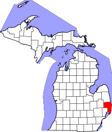 | |
| Villages | ||
| Charter townships | ||
| General law townships | ||
| CDP | ||
| Other unincorporated communities |
| |
| Footnotes | ‡This populated place also has portions in an adjacent county or counties | |
Central/Mid-Michigan including the Tri-Cities and Thumb | |||||||||||
|---|---|---|---|---|---|---|---|---|---|---|---|
| Central cities | |||||||||||
| Counties |
| ||||||||||
| Geography | |||||||||||
| Transportation | |||||||||||
| Economy | |||||||||||