Port of New York and New Jersey
Coordinates: 40°40′06″N 74°02′44″W / 40.66833°N 74.04556°W
| Port of New York and New Jersey | |
|---|---|
|
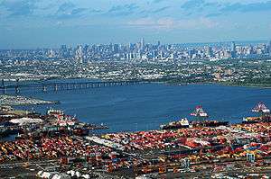
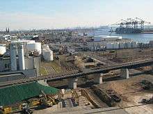
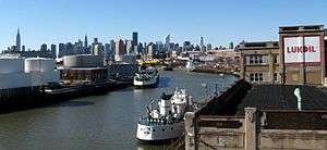
Port Newark-Elizabeth Marine Terminal on Newark Bay is the busiest container terminal on the East Coast of the United States | |
| Details | |
| Draft depth | 50 feet |
| Air draft |
228 feet, restricted by Verrazano–Narrows Bridge 151 feet, restricted by Bayonne Bridge (with reconstruction will be raised to 215 feet clearance) |
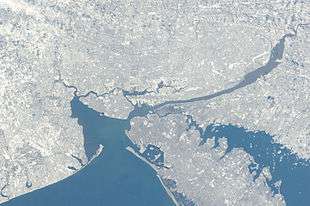
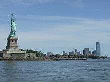
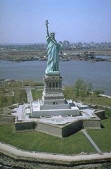
The Port of New York and New Jersey is the port district of the New York-Newark metropolitan area, encompassing the region within approximately a 25-mile (40 km) radius of the Statue of Liberty National Monument. It includes the system of navigable waterways in the estuary along 650 miles (1,050 km) of shoreline in the vicinity of New York City and northeastern New Jersey, as well as the region's airports and supporting rail and roadway distribution networks. Considered one of the largest natural harbors in the world, the port is by tonnage the third largest in the United States and the busiest on the East Coast.
The port is the nation's top gateway for international flights and its busiest center for overall passenger and air freight flights. There are two foreign-trade zones (FTZ) within the port. The port handled $208 billion in shipping cargo in 2011, and 3,342,286 containers and 393,931 automobiles in 2014.
Geography
The port is one of the largest natural harbors globally.[1]
Port district
Encompassing an area within an approximate 25-mile (40 km) radius of the Statue of Liberty National Monument, the port district comprises all or part of seventeen counties in the region. The ten that are completely within the district are Hudson, Bergen, Essex, Union (in New Jersey), Westchester (in New York), and the five boroughs of New York City, which are coterminous with the counties of New York, Bronx, Kings, Queens, and Richmond. Abutting sections of Passaic, Middlesex, Monmouth, Morris, and Somerset in New Jersey, and Nassau and Rockland in New York are also within the district.[2][3]
Waterways
Bodies of water
The Atlantic Ocean is to the southeast of the port. The sea at the entrance to the port is called the New York Bight; it lies between the peninsulas of Sandy Hook and Rockaway. In Lower New York Bay and its western arm, Raritan Bay, vessels orient themselves for passage to the east into Arthur Kill or Raritan River or to the north to The Narrows. To the east lies the Rockaway Inlet, which leads to Jamaica Bay. The Narrows connects to the Upper New York Bay at the mouth of the Hudson River, which is sometimes (particularly in navigation) called the North River. Large ships are able to navigate upstream to the Port of Albany-Rensselaer. To the west lies Kill van Kull, the strait leading to Newark Bay, fed by the Passaic River and Hackensack River, and the northern entrance of Arthur Kill. The Gowanus Canal and Buttermilk Channel are entered from the east. The East River is a broad strait that travels north to Newtown Creek and the Harlem River, turning east at Hell Gate before opening to Long Island Sound, which provides an outlet to the open sea.
Channels
The port consists of a complex of approximately 240 miles (386 km) of shipping channels, as well as anchorages and port facilities.[5][6][7] Most vessels require pilotage,[8][9][10] and larger vessels require tugboat assistance for the sharper channel turns.
The Ambrose leads from the sea to the Upper Bay, where it becomes the Anchorage Channel.[11] Connecting channels are the Bay Ridge, the Red Hook, the Buttermilk, the Claremont, the Port Jersey, the Kill Van Kull, the Newark Bay, the Port Newark, the Elizabeth, and the Arthur Kill. Anchorages are known as Stapleton, Bay Ridge and Gravesend.[12]
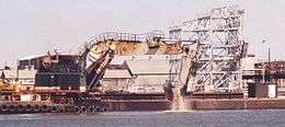
The natural depth of the harbor is about 17 feet (5 m), but it was deepened over the years, to a controlling depth of about 24 feet (7 m) in 1880.[13] By 1891, the Main Ship Channel was minimally 30 feet (9 m) deep. In 1914, Ambrose Channel became the main entrance to the port, at 40 feet (12 m) deep and 2,000 feet (600 m) wide. During World War II the main channel was dredged to 45 feet (14 m) deep to accommodate larger ships up to Panamax size. In 2016, the Army Corps of Engineers completed a $2.1 billion dredging project, deepening harbor channels to 50 feet (15 m) in order to accommodate Post-Panamax container vessels, which can pass through the widened Panama Canal as well as the Suez Canal.[14][15][16] This has been a source of environmental concern along channels connecting the container facilities in Port Newark to the Atlantic. PCBs and other pollutants lay in a blanket just underneath the soil.[17] In June 2009 it was announced that 200,000 cubic yards of dredged PCBs would be "cleaned" and stored en masse at the site of the former Yankee Stadium and at Brooklyn Bridge Park.[18] In many areas the sandy bottom has been excavated down to rock and now requires blasting. Dredging equipment then picks up the rock and disposes of it. At one point in 2005, there were 70 pieces of dredging equipment working to deepen channels, the largest fleet of dredging equipment anywhere in the world.
The channel of the Hudson is the Anchorage Channel and is approximately 50 feet deep in the midpoint of Upper Bay.[19] A project to replace two water mains between Brooklyn and Staten Island, which will eventually allowing for dredging of the channel to nearly 100 feet (30 m), was begun in April 2012.[20][21] The Army Corps has recommended that most channels in the port be maintained at 50 feet deep.[22] Dredging of the canals to 50 get was completed in August 2016.[23][24]
Pilotage
The Sandy Hook Pilots are licensed maritime pilots that go aboard oceangoing vessels, passenger liners, freighters, and tankers and are responsible for the navigation of larger ships through port district.
History
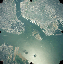
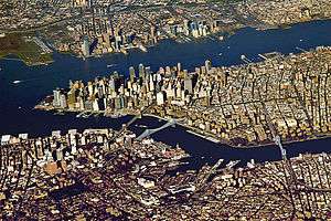
Manhattan (left), Brooklyn (top) and Jersey City (bottom)
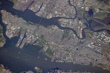
Ellis Island (left) and Liberty Island (right), Governors Island (the largest at center)
The estuary was originally the territory of the Lenape, a seasonally migrational people who would relocate summer encampments along its shore and use its waterways for transport and fishing. Many of the tidal salt marshes supported vast oyster banks that remained a major source of food for the region until the end of the 19th century, by which time contamination and landfilling had obliterated most of them.[25]
The first recorded European visit was that of Giovanni da Verrazzano, who anchored in The Narrows in 1524. For the next hundred years, the region was visited sporadically by ships on fishing trips and slave raids. European colonization began after Henry Hudson's 1609 exploration of the region with the establishment of New Amsterdam, the capital of the Dutch province of New Netherland at the tip of Manhattan. The British colonial era saw a concerted effort to expand the port in the triangular trade between Europe, Africa, and North America with a concentration of wharves along the mouth of the East River. After the Battle of Brooklyn, the British controlled the harbor for the duration of American Revolutionary War, and prison ships housed thousands at Wallabout Bay.
In the early 19th century, the Erie Canal (often used for grain) and Morris Canal (mostly used for anthracite) gave the port access to the American interior, leading to transshipment operations, manufacturing, and industrialization. The invention of the steam engine led to expansion of the railroads and vast terminals along the western banks of the Hudson River, complemented by an extensive network of ferries and carfloats, with a large cluster along the Harlem River.
The era of the ocean liner around the turn of the 20th century led to the creation of berths at North River piers and Hoboken.[26] This coincided with the immigration of millions, processed at Castle Clinton and later at Ellis Island, some staying in the region, others boarding barges, ships, and trains to points across the United States.[27] In 1910, the port was the busiest in the world.[28]
During the World Wars the waterfront supported shipyards and military installations such as the Federal Shipbuilding and Drydock Company and the Brooklyn Navy Yard and played an important role in troop transport as a Port of Embarkation. The mid-century also saw the construction of major highways such as the Belt Parkway, East River Drive, and Major Deegan Expressway along parts of the shoreline.
The era of the longshoreman, captured in the classic film On the Waterfront, faded by the 1970s as much of the waterfront became obsolete due to changing transportation patterns. The nation's first facility for container shipping, which became the prototype, opened in 1958. Expanded intermodal freight transport systems and the Interstate Highway System effected a shift to new terminals at Newark Bay.[29] Since the 1980s, sections of waterfront in the traditional harbor have been being redeveloped to include public access to the water's edge, with the creation of linear park greenways such as Hudson River Park, Hudson River Waterfront Walkway, and Brooklyn Bridge Park.[30]
Jurisdiction and regulation
Responsibilities within the port are divided among all levels of government, from municipal to federal, as well as public and private agencies.
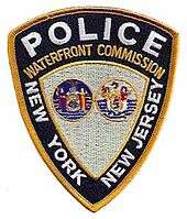
Established in 1921, the bi-state Port Authority of New York and New Jersey, in addition to overseeing maritime facilities, is responsible for the vehicular crossings and the rapid transit system between New York and New Jersey, several of the region's airports, and other transportation and real estate development projects.[29] The Port Authority maintains its own police force, as does the Waterfront Commission, created in 1953 to investigate, prosecute, and prevent criminal activity.[31] The United States Army Corps of Engineers, which has been involved in harbor maintenance since about 1826, when Congress passed an omnibus rivers and harbors act,[32][33] is responsible for bulkhead and channel maintenance.[32][33] The United States Coast Guard deals with issues such as floatable debris,[34] spills, vessel rescues, and counter-terrorism.[35] Both states, and some municipal governments – in particular New York City – maintain maritime police units, while the United States Park Police monitors federal properties. The National Park Service oversees some of the region's historic sites, nature reserves, and parks. As a port of entry with sections that are foreign trade zones,[36] U.S. Customs and Border Protection and U.S. Immigration and Customs Enforcement regulate international imports and passenger arrivals and the "green lane" program, in which trusted shippers have fewer containers inspected.[37] There are two foreign trade zones in the port: FTZ 1, the first in the nation, established in 1937, on the New York side of the port; and FTZ 49, on the New Jersey side.[38][39][40] In 2010, 4,811 ships entered the harbor carrying over 32.2 million metric tons of cargo valued at over $175 billion.[41]
In March 2006, some of the passenger facilities management was to be transferred to Dubai Ports World.[42] There was considerable controversy over security and ownership by a foreign corporation, particularly Arabic, of a U.S. port operation, despite the fact that the operator was British-based P&O Ports.[43] DP World later sold P&O's American operations to American International Group's asset management division, Global Investment Group, for an undisclosed sum.[44]
Seamen's Church Institute of New York and New Jersey, the Teamsters, and the International Longshoremen's Association assist and represent some of the port's mariners and dockworkers.[45]
Cargo infrastructure
Airports
The airports in the Port of New York and New Jersey combine to create the largest airport system in the United States, the second in the world in terms of passenger traffic, and the first in the world in terms of total flight operations. JFK air freight cargo operations make it the busiest in the US. FedEx Express, the world's busiest cargo airline, uses Newark Liberty International Airport as its regional hub.
Container terminals
There are four container terminals in the port, whose combined volume makes it the largest on the East Coast,[46][47][48] the third busiest in the United States,[49] and 20th worldwide. Terminals are leased to different port operators,[50] such as A. P. Moller-Maersk Group, American Stevedoring,[51] NYCT,[52] and Global Marine Terminal.[53]
- Howland Hook Marine Terminal
- Port Jersey Marine Terminal
- Port Newark-Elizabeth Marine Terminal, the nation's first and third busiest
- Red Hook Marine Terminal
Approximately 3,200,000 twenty-foot equivalent units (TEU) of containers and 700,000 automobiles are handled per year.[54] In the first half of 2014, the port handled 1,583,449 containers, a 35,000-container increase above the six-month record set in 2012,[55] while the port handled a monthly record of 306,805 containers in October 2014.[56] In June 2010, the Port Authority of New York and New Jersey agreed to purchase from Bayonne 128 acres (0.52 km2) of land at the Military Ocean Terminal at Bayonne, indicating that additional container port facilities would be created.[57] The agency is expected to develop a terminal capable of handling the larger container ships to be in service once the new, wider Panama Canal opens in 2014, some of which will not pass under the Bayonne Bridge at the Kill van Kull.[58] A project to raise to the roadway of the bridge within the existing arch is underway.[59]
ExpressRail
ExpressRail is rail network supporting intermodal freight transport at the major container terminals of the port. The development of dockside trackage and railyards for transloading has been overseen by the Port Authority of New York and New Jersey which works in partnership other public and private stakeholders. Various switching and terminal railroads, including the Conrail Shared Assets Operations (CRCX) on the Chemical Coast Secondary connect to the East Coast rail freight network carriers Norfolk Southern (NS), CSX Transportation (CSX), and Canadian Pacific (CP).[60][61] In the year period ending October 2014 the total amount of TEUs of Intermodal containers handled at the port included 391,596 rail lifts.[62] As of 2014, three ExpressRail systems (Newark, Elizabeth, and Staten Island) were in operation. Construction of a fourth, with connection to the National Docks Secondary, is underway at Port Jersey. Financed by a surcharge on all containers passing through the port by train or truck and the system in 2014 handled just over 14% of total container volume.[55]
Bulk cargo and marine transfer
While most consumer goods are transported in containers, other commodities such as petroleum and scrap metal are handled at facilities for marine transfer operations, bulk cargo, and break bulk cargo throughout the port, many along its straits and canals. At some locations, water pollution has led to inclusion on the list of Superfund sites in the United States.
- Arthur Kill, along its shore the Bayway Refinery and the Chemical Coast
- Kill van Kull at Constable Hook
- Gowanus Canal in South Brooklyn
- Newtown Creek, East River at Greenpoint and Hunter's Point
- Passaic River from Newark Bay to Passaic
- South Brooklyn Marine Terminal[63]
Car float and Cross Harbor Tunnel
At one time nearly 600,000 railcars were transferred annually by barge between the region's extensive rail facilities. Today approximately 1,600 cars are "floated" on the remaining car float in the port. The New York New Jersey Rail, LLC transfers freight cars across the Upper Bay between the Greenville Yard in Jersey City and the 65th Street Yard and the Bush Terminal Yard in Brooklyn.[64] At the Greenville end, CSX Transportation operates through Conrail's North Jersey Shared Assets Area along the National Docks Secondary. At Brooklyn, end connections are made to the New York and Atlantic Railway's Bay Ridge Branch and the South Brooklyn Railway. The 2.5-mile (4.0 km) crossing takes approximately 45 minutes. The equivalent truck trip would be 35 to 50 miles (80 km) long.[65]
Freight rail has never used the New York Tunnel Extension under the Hudson Palisades, Hudson River, Manhattan, and East River due to electrified lines and lack of ventilation. Overland travel crosses the Hudson River 140 miles (225 km) to the north using a right of way known as the Selkirk hurdle. The Cross-Harbor Rail Tunnel is a proposed rail tunnel under the Upper Bay. The western portal would be located at Greenville Yard, while the eastern portal is undetermined and a source of controversy.[66]
In May 2010, the Port Authority announced that it would purchase the Greenville Yard and build a new barge-to-rail facility there, as well as improve the existing railcar float system. The barge-to-rail facility is expected to handle an estimated 60,000 to 90,000 containers of solid waste per year from New York City, eliminating up to 360,000 trash truck trips a year. The authority's board authorized $118.1 million for the project.[67] The National Docks Secondary rail line is being upgraded in anticipation of expanded volumes.
In September 2014, the PANYNJ announced a $356 million capital project to upgrade and expand the facility, including Roll-on/roll-off operations. Expected to be operational about July 2016, an initial capacity of at least 125,000 cargo container lifts a year is projected.[68]
Port Inland Distribution Network
The Port Inland Distribution Network involves new or expanded transportation systems for redistribution by barge and rail for the shipped goods and containers that are delivered at area ports in an effort to curtail the use of trucks and their burden on the environment, traffic, and highway systems. The Port Authority of New York and New Jersey (PANYNJ), New Jersey Department of Transportation (NJDOT), and Delaware Valley Regional Planning Commission (DVRPC), are involved in initiatives to review and develop this network.[69][70][71]
America's Marine Highway is a similar US Dept.of Transportation initiative to capitalize on US waterways for the transport of goods.[72][73] In 2010, a private sector service provider began short sea shipping of aggregate products with a barge service between Tremley Point, Linden on the Arthur Kill and the Port of Salem to address a critical, yet weak link in freight transport with ports in the Delaware Valley.[73]
Cruise terminals and ferries
Cruise terminals
The golden age of the North Atlantic ocean liner lasted from the end of the 19th century to the post–World War II period, after which innovations in air travel became commercially viable. Many berths for the great ships that lined the North River (Hudson River) were more or less abandoned by the 1970s. Nowadays most travel is recreational. While many cruises are to points in the Caribbean, there are also ships calling at the port that sail transatlantically and to the Southern Hemisphere, notably RMS Queen Mary 2. The passenger cruise ship terminals in the port are located in the traditional, or "inner", harbor.
- Cape Liberty Cruise Port, MOTBY, Upper Bay[74]
- Brooklyn Cruise Terminal, Buttermilk Channel, Upper Bay[75]
- New York Passenger Ship Terminal, Hudson River[76]
Ferries and sightseeing
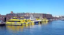
There has been continuous ferry service between Staten Island and Lower Manhattan since the 18th century. Travelling across the Upper Bay between South Ferry and St. George Ferry Terminal, the free Staten Island Ferry transports on average 75,000 passengers per day.
Service on the East River ended in the early 20th century and on the Hudson River in the 1960s. It has been restored and grown significantly since the 1980s providing regular service to points in Manhattan, mostly below 42nd Street. Major terminals are Hoboken Terminal, Battery Park City Ferry Terminal at World Financial Center, Paulus Hook Ferry Terminal, Weehawken Port Imperial, Pier 11/Wall Street, West Midtown Ferry Terminal, and the East 34th Street Ferry Landing. There also are numerous ferry slips that each serve one route only, including the historic Fulton Ferry. In addition to regular and rush hour routes, there are excursions, trips, and seasonal service to Gateway National Recreation Area beaches. Sightseeing boats circumnavigate Manhattan or make excursions into the Upper New York Bay.[77]
- Circle Line Downtown[78]
- Circle Line Sightseeing[79]
- Ellis Island and Liberty Island[80][80][81][82]
- Governor's Island Ferry[83] (seasonal)
- Liberty Water Taxi[84]
- New York Water Taxi[85]
- NY Waterway[86]
- New York Beach Ferry
- SeaStreak[87]
- Staten Island Ferry[88]
Lights and lighthouses
There are both historic and modern lighthouses throughout the port, some of which have been decommissioned[89][90]
- Ambrose Light, Lower Bay (dismantled 2008)
- Bergen Point Light, Newark Bay (replaced)
- Blackwell Island Light, Roosevelt Island, East River (retired 1940)
- Chapel Hill Rear Range Light, Sandy Hook Bay (deactivated 1957)
- Conover Beacon (front range light), Leonardo
- Coney Island (Nortons Point) Light, Lower New York Bay, Sea Gate, Brooklyn
- Elm Tree Beacon Light, The Narrows, New Dorp, Staten Island
- Execution Rocks Light, Long Island Sound
- Fort Tompkins Light, The Narrows, Staten Island (retired)
- Fort Wadsworth Light, The Narrows, Brooklyn
- Great Beds Light, Raritan Bay, South Amboy
- Kings Point Light, Long Island Sound, Great Neck
- Kingsborough Community College Light, Sheepshead Bay, Brooklyn
- Little Gull Island Light, Long Island Sound
- Little Red Lighthouse (Jeffrey's Hook Lighthouse), Fort Washington, Manhattan
- Navesink Twin Lights, Sandy Hook Bay, Highlands
- New Dorp Light, The Narrows, Staten Island Swash Channel (retired)
- North Brother Island Light, East River
- Old Orchard Shoal Light, Gedney Channel, lLower Bay
- Princes Bay Light, Staten Island
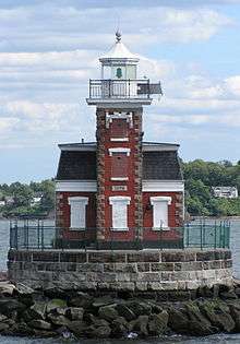
- Robbins Reef Light, Constable Hook, Upper Bay,
- Romer Shoal Light, Lower Bay near Sandy Hook Bay
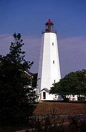
- Sandy Hook Light, Sandy Hook
- Staten Island Light Lighthouse Hill, Staten Island
- Statue of Liberty, Liberty Island, Upper Bay (until 1902)
- Stepping Stones Light, Long Island Sound, near City Island
- Stony Point light, Hudson River
- Throgs Neck Light, Throggs Neck, East River (decommissioned)
- Titanic Memorial, South Street Seaport, East River,
- West Bank Light, Ambrose Channel, Lower Bay (range front)
- Whitestone Point Light, Whitestone Point, southerly side of East River
Land reclamation and ocean dumping
Channelization and landfilling began in the colonial era and continued well into the 20th century.[91] Early materials were shellfish and other refuse, and later construction debris from projects such as the New York City Subway and Pennsylvania Station. Rubble from the bombing of London was transported for ballast during World War II. New land has been created throughout the port, including large swaths that are now Battery Park City, Ellis Island, Liberty State Park, Flushing Meadows–Corona Park, and the Meadowlands Sports Complex.[92][93][94]
From 1924 until 1986, sewerage sludge was hauled by tugboat and barge to a point 12 miles (19 km) offshore in the Atlantic. From 1986 to 1992 it was dumped at a site 106 nautical miles from Atlantic City, after which ocean dumping was banned.[95][96][97] Barges were also used to transport waste to Fresh Kills Landfill, the world's largest, which operated from 1948 to 1991. Both operations were known to be detrimental to Long Island and Jersey Shore beaches, notably the 1987 Syringe Tide.[98][99]
Tourism and recreation
Harbor-related historic sites, promenades, and nature preserves within the port district include:
- South Street Seaport
- Intrepid Sea-Air-Space Museum
- Gateway National Recreation Area
- Statue of Liberty National Monument, Ellis Island and Liberty Island and Governor's Island
- Hudson River Park, Hudson River Waterfront Walkway, Brooklyn Bridge Park
- Liberty State Park and Communipaw Terminal
- Battery Park and Castle Clinton
- Hackensack Meadowlands, Riverwalk, and Environment Center
- Pier 63, New York Central Railroad 69th Street Transfer Bridge, and 79th Street Boat Basin
- Gantry Plaza State Park
- Manhattan Waterfront Greenway
- Hoboken Terminal
- City Island
Economy
In 2014, the port handled 3,342,286 containers and 393,931 automobiles.[100]
In January through June 2015, the top 10 imports that went through the port of New York and New Jersey were:[101]
- Petroleum: $6.78 billion
- Appliances: $3,80 billion
- Vehicles: $2.59 billion
- Plastics: $1.72 billion
- Electronics: $1.46 billion
- Chemicals: $1.45 billion
- Oils and perfumes: $928.7 million
- Pharmaceuticals: $897.5 million
- Optical and photographic: $801.8 million
- Pearls and precious gems and metals: $562.4 million
See also
- Timeline of Jersey City, New Jersey-area railroads
- Rail freight transportation in New York City and Long Island
- List of bridges, tunnels, and cuts in Hudson County, New Jersey
- New York tugboats
- Vision 2020: New York City Comprehensive Waterfront Plan
- List of ports in the United States
- List of North American ports
- List of world's busiest container ports
- Marine life of New York-New Jersey Harbor Estuary
- Port of Paulsboro
- United States container ports
References
- ↑ "Port in a Storm: The Port of New York in World War II", Joseph F. Meany Jr. & al., NY State Museum, 1992-1998.
- ↑ 2012 Port Map, PANYNJ, January 2012
- ↑ http://www.panynj.gov/corporate-information/foi/12316-LPA.pdf
- ↑ "Dredging Today – Dredging Operations to Continue in Kill van Kull (USA)". Dredgingtoday.com. 2010-11-23. Retrieved 2012-08-03.
- ↑ Chapter 11, New York Harbor and Approaches, Coast Pilot 2, 35th Edition, 2006, Office of Coast Survey, NOAA.
- ↑ US Army Corps of Engineers map of channels
- ↑ "Controlling Depth Reports and Surveys". United States Army Corps of Engineers (New York District). Retrieved 2013-03-15.
- ↑ Sandy Hook Pilots
- ↑ Wertenbaker, William. "A Reporter at Large: THE SANDY HOOK PILOTS.". The New Yorker. Retrieved 2012-08-03.
- ↑ Wertenbaker, William (September 14, 1968). "Reporter at Large". The Sandy Hook Pilots. The New Yorker. Retrieved 2011-02-14.
- ↑ "Ambrose Federal Navigation Channel". US Army Corps of Engineers.
- ↑ "Intent To Prepare a Draft Environmental Impact Statement (DEIS) for the New York and New Jersey Harbor Navigation Study: Feasibility Phase". Federal Register Volume 63. Government Printing Office. March 24, 1998. Retrieved 2014-08-31.
- ↑ [http://www.gothamgazette.com/article//20060213/202/1755 Interview with Kate Ascher on her book The Works: Anatomy of a City, in Gotham Gazette, February 2006.
- ↑ Why Deepen the Port?, USACE.
- ↑ Dredging Fleet Deepening NY/NJ Harbor, PortViews, Vol. 2, No. 3 October 2003, PANYNJ.
- ↑ In major milestone, Port Authority, Army Corps complete $2.1B harbor deepening project, Jonathan Lin, The Jersey Journal, September 1, 2016
- ↑ Dredging In New York Harbor -- Economy vs. Environment?, Gotham Gazette, April 2006.
- ↑ City Dumping Tons of Possibly Toxic Sludge in Parks, Elsewhere in City, the Village Voice, June 22, 2009
- ↑ Anchorage Channel dredging project]
- ↑ "NY Mayor Bloomberg Helps Launch New York Harbor Siphons Project" (PDF). Tunnel Business Magazine. June 2012. p. 7. Retrieved 2013-10-15.
- ↑ "Replacement of Anchorage Channel Water Siphons". New York City Economic Development Commission. February 13, 2013. Retrieved 2012-03-15.
- ↑ http://www.usace.army.mil/Portals/2/docs/civilworks/Chiefs_Report/ny_nj_harbor.pdf
- ↑ http://www.joc.com/port-news/us-ports/port-new-york-and-new-jersey/ny-nj-port-completes-50-foot-channel-project_20160902.html
- ↑ http://www.panynj.gov/port/harbor-deepening.html
- ↑ Kurlansky, Mark (2006). The Big Oyster. New York: Random House Trade paperbacks. ISBN 978-0-345-47639-5.
- ↑ Working Waterfront
- ↑ Cunningham, John T. (2003). Ellis Island: Immigration's Shining Center. Arcadia Publishing. ISBN 978-0-7385-2428-3.
- ↑ "WATER FRONTAGE AROUND NEW YORK; Values and Needs for Better Shipping Facilities Explained by Floyd S. Corbin". The New York Times. 1910-04-03.
- 1 2 History of the Port Authority
- ↑ Santora, Marc (2010-11-05). "New York's Next Frontier: The Waterfront". The New York Times.
- ↑ Waterfront Commission of New York Harbor (WCNYH).
- 1 2 Controlling Depth Reports for navigation channels, USACE
- 1 2 Chapter 3, River and Harbor Improvement, History of the Waterways of the Atlantic Coast of the United States, Publication Number NWS 83-10, January 1983, USACE.
- ↑ Floatable Debris, accessed 2010-05-01
- ↑ U.S. Coast Guard Sector New York Homepage.
- ↑ Foreign Trade Zone 49
- ↑ The Docks of New York, The New Yorker, June 19, 2006.
- ↑ "U.S. Foreign-Trade Zones". Import Administration. International Trade Administration. January 13, 2013. Retrieved 2013-01-20.
- ↑ Tiefenbrun, Susan (2012), Tax Free Trade Zones Of The World And In The United States, Edward Elgar Publishing, ISBN 978 1 84980 243 7
- ↑ "Foreign-Trade Zone 49". PANYNJ. Retrieved 2013-01-20.
- ↑ Walsh, Kevin J., "The Port of New York and New Jersey, a critical Hub of Global Commerce", Forbes, retrieved 2011-10-27
- ↑ Berkey-Gerard, Mark; Arnow, Pat (March 2003). "New York's Port, Beyond Dubai". Gotham Gazette. Retrieved 2007-02-19.
- ↑ Fact Sheet on Acquisition of P&O Ports by DP World, American Association of Port Authorities, 2006.
- ↑ King Jr., N.; Hitt, G. (2006-12-11). "Dubai Ports World Sells U.S. Assets". The Wall Street Journal.
- ↑ The RICO Trusteeships after Twenty Years, 2004, ABA, republished by Laborers for JUSTICE. US v. Local 560, et al., Civil Action No. 82-689, US District of New Jersey, February 8, 1984.
- ↑ American Association of Port Authorities (2008), Port Industry Statistics, retrieved 2010-05-01
- ↑ Lipton, Eric (2004-11-22). "New York Port Hums Again, With Asian Trade". The New York Times.
- ↑ Finnegan, William. "A Reporter at Large: Watching the Waterfront". The New Yorker. Retrieved 2012-08-03.
- ↑ PANYNJ Container Shipping
- ↑ PANYNJ Ocean shipping
- ↑ "American Stevedoring Inc". Asiterminals.com. Retrieved 2012-08-03.
- ↑
- ↑ "Global Terminal". Global Terminal. Retrieved 2012-08-03.
- ↑ LaRocco, Lori Ann (January 14, 2013). "'Container Cliff' Talks Race to Avert Crippling Feb. Strike". CNBC. Retrieved 2013-01-16.
- 1 2 Strunsky, Steve (August 5, 2014). "Port reports record container volume for first half of 2014". The Star-Ledger. Retrieved 2014-12-16.
- ↑ "NY-New Jersey cargo sets record for October". North Jersey Media Group. December 5, 2014. Retrieved December 5, 2014.
- ↑ Jersey Journal file photo. "Bayonne board votes to sell land at Harbor to Port Authority". NJ.com. Retrieved 2012-08-03.
- ↑ "Will open a port not new housing BLRA sells waterfront property to Port Authority for 235M". Hudson Reporter. 2010-08-04. Retrieved 2012-08-03.
- ↑ "Bayonne Bridge Navigational Clearance Program". PANYNJ. Retrieved 2013-04-12.
- ↑ "Local Rail" (PDF). PANYNJ. Retrieved 2014-12-11.
- ↑ "The Port Authority ExpressRail System". PANYNJ. Retrieved 2014-12-09.
- ↑ "Loaded Containers in TEUs and Total ExpressRail Lifts by Month". PANYNJ. October 2014. Retrieved 2014-12-09.
- ↑ "The Port Authority of NY & NJ Port Guide". Seaportsinfo.com. Retrieved 2012-08-03.
- ↑ NYNJ Railroad
- ↑ NYRR 10-K SEC filing for 2003
- ↑ "Cross Harbor Freight Program - Studies & Reports - The Port Authority of NY & NJ". Crossharborstudy.com. 2001-09-11. Retrieved 2012-08-03.
- ↑ "PORT AUTHORITY BOARD APPROVES PURCHASE AND REDEVELOPMENT OF GREENVILLE YARDS, INCLUDING A BARGE-TO-RAIL FACILITY TO TAKE TRUCKS OFF THE ROAD" (Press release). PANYNJ. May 18, 2010. Retrieved 2010-12-02.
- ↑ "PANYNJ board approves Greenville Yard redevelopment". RT&S. September 18, 2014. Retrieved 2014-12-05.
- ↑ "Fact Sheet Port Inland Distribution Network" (PDF). Port Authority of New York and New Jersey. July 2004. Retrieved 2013-07-31.
- ↑ "Port Authority Launches Unique Cargo Distribution System by Establishing First Regional Port in Upstate New York". Port Authority of New York and New Jersey. December 13, 2002. Retrieved 2013-07-31.
- ↑ Rodrigue, Jean-Paul. "Port Inland Distribution Network of the Port of New York and New Jersey". Geography of Transport Systems. Hofstra University. Retrieved 2013-07-31.
- ↑ "U.S. Transportation Secretary LaHood Announces Corridors, Projects and Initiatives Eligible for Funding as Part of America's Marine Highway" (Press release). UDDOT Maritime Administration. August 22, 2010. Retrieved 2013-07-31.
- 1 2 "Application for the Designation of the New Jersey Marine Highway Platform as a Marine Highway Project" (PDF). New Jersey Department of Transportation. June 11, 2010. Retrieved 2013-07-31.
- ↑ Cape Liberty Cruise Port
- ↑ Brooklyn Cruise Terminal
- ↑ New York Passenger Terminal
- ↑ Brief history of ferries in Port of New York
- ↑
- ↑ Circle Line Sightseeing Cruises
- 1 2 Ellis Island and Liberty Island Ferry Map
- ↑ Statue of Liberty & Ellis Island information at Star Cruises; Accessed August 31, 2010
- ↑ "Hornblower Cruises". Statuecruises.com. Retrieved June 10, 2010.
- ↑ Governor's Island Ferry
- ↑ Statue Cruises|Liberty Water Taxi
- ↑ New York Water Taxi
- ↑ NY Waterway
- ↑ SeaStreak Official site
- ↑ Staten Island Ferry
- ↑ "Historic Light Station Information and Photography: New Jersey". United States Coast Guard Historian's Office.
- ↑ "Historic Light Station Information and Photography: New York". United States Coast Guard Historian's Office.
- ↑ Lobell, Jarrett A.. (2010-07-13) Archaeology Magazine - The Hidden History of New York's Harbor - Archaeology Magazine Archive. Archive.archaeology.org. Retrieved on 2013-07-15.
- ↑ "HISTORIC FILL OF THE JERSEY CITY QUADRANGLE HISTORIC FILL MAP HFM-53" (PDF). New State Department of Environmental Protection. 2004. Retrieved 2014-08-31.
- ↑ "Is Liberty a Jersey Girl". New Jersey Society of Professional Land Surveyors. February 4, 2014.
- ↑ http://untappedcities.com/2013/10/09/the-man-made-areas-of-nyc-governors-island-ellis-island-freshkills-park-battery-park-marble-hill-u-thant-island/
- ↑ "Reilly in New York to Mark End of Sewage Sludge Dumping". United States Environmental Protection Agency. June 30, 1992. Retrieved 2013-10-09.
- ↑ "Research & Articles on Ocean Dumping Ban Act (1988) by". BookRags.com. Retrieved 2012-08-03.
- ↑ Gold, Allan R. (1991-03-18). "New Jersey Ends Practice Of Dumping Sludge in Sea". The New York Times.
- ↑ Alfonso Narvaez (8 December 1987). "New York City to Pay Jersey Town $1 Million Over Shore Pollution". The New York Times. Retrieved 2008-06-25.
- ↑ "A Summary of the Proposed Comprehensive Conservation and Management Plan". New York-New Jersey Harbor Estuary Program. February 1995. Retrieved 2008-06-25.
- ↑ Strunsky, Steve (February 2, 2015). "Port of N.Y. and N.J. handled record cargo volume in 2014". The Star-Ledger. Retrieved 2015-04-15.
- ↑ 10 tops imports to PortNYNJ 2015
External links
- Official homepage
- PANYNJ Rail terminal and intermodal facilities
- New York Sector for US Coast Guard (Home Port website)
- 2012 Port Guide (PDF), PANYNJ, archived from the original (PDF) on July 23, 2012
- Economic Impact of New York-New Jersey Port/Maritime Industry for 2010 (PDF) (Report). PANYNJ. October 2011.
- New York-New Jersey Harbor & Estuary Program
- Maritime Association of the Port of New York and New Jersey (Schedule of latest ship departures and related information)
- NY Times 2004 slide show of port facilities and activities
| Bridges of the Newark Bay | ||||
|---|---|---|---|---|
| ||||