Prétot-Sainte-Suzanne
| Prétot-Sainte-Suzanne | |
|---|---|
|
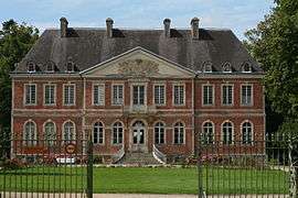
The chateau of Sainte-Suzanne | |
 Prétot-Sainte-Suzanne | |
|
Location within Normandy region  Prétot-Sainte-Suzanne | |
| Coordinates: 49°19′32″N 1°26′09″W / 49.3256°N 1.4358°WCoordinates: 49°19′32″N 1°26′09″W / 49.3256°N 1.4358°W | |
| Country | France |
| Region | Normandy |
| Department | Manche |
| Arrondissement | Coutances |
| Canton | Créances |
| Intercommunality | Communauté de communes de la Haye-du-Puits |
| Government | |
| • Mayor (2014–2020) | Thierry Renaud |
| Area1 | 11.64 km2 (4.49 sq mi) |
| Population (2006)2 | 334 |
| • Density | 29/km2 (74/sq mi) |
| Time zone | CET (UTC+1) |
| • Summer (DST) | CEST (UTC+2) |
| INSEE/Postal code | 50415 / 50250 |
| Elevation |
4–44 m (13–144 ft) (avg. 36 m or 118 ft) |
|
1 French Land Register data, which excludes lakes, ponds, glaciers > 1 km² (0.386 sq mi or 247 acres) and river estuaries. 2 Population without double counting: residents of multiple communes (e.g., students and military personnel) only counted once. | |
Prétot-Sainte-Suzanne is a former commune in the Manche department in Normandy in north-western France.On 1 January 2016, it was merged into the new commune of Montsenelle.[1]
See also
References
- ↑ Arrêté préfectoral 20 November 2015 (French)
| Wikimedia Commons has media related to Prétot-Sainte-Suzanne. |
This article is issued from Wikipedia - version of the 3/31/2016. The text is available under the Creative Commons Attribution/Share Alike but additional terms may apply for the media files.