Prince Alfred Bridge
| Prince Alfred Bridge | |
|---|---|
 | |
| Carries | Road |
| Crosses | Murrumbidgee river |
| Locale | Gundagai, Australia |
| Characteristics | |
| Design | wrought iron truss & timber beam |
| Total length | 921 m |
| Width | 10 m |
| Longest span | 40 m |
| History | |
| Opened | 1867 |
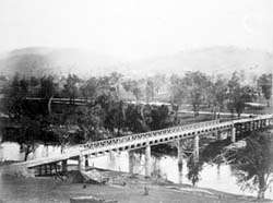
The Prince Alfred Bridge is a wrought iron truss and timber beam road bridge over the Murrumbidgee River and its floodplain at Gundagai, New South Wales.[1]
The bridge was named for the then reigning Queen Victoria's son, Prince Alfred, Duke of Saxe-Coburg and Gotha, and was built to carry the Great Southern Road (now the Hume Highway) across the Murrumbidgee. It has existed in three forms, with only the main spans across the river itself being common to all three.
As opened in 1865 the bridge had a total length of 314 m, consisting of three wrought iron truss spans each of 31.4 m across the river, two timber southern approach spans each of 9.14 m, and twenty-three timber northern approach spans each of 9.14 m, rising on a gradient of 1 in 30 from the level of the floodplain.[2]
It was the first iron truss bridge to be built in New South Wales,[3] and was designed by William Bennett, Engineer and Commissioner for Roads [4] and constructed by Francis Bell.[5] The trusses were assembled from iron work imported from England and the cast-iron cylinders for the main piers were cast at the Fitzroy Iron Works at Mittagong. The pin-jointed Warren truss section is the second-oldest metal truss bridge in Australia.
Sometime between 1865 and 1896 the second configuration of the bridge was built by the twenty-three northern approach spans being replaced by a much longer structure which spanned the full width of the floodplain. It consisted of 105 timber spans varying from 4.6 m to 9.14 m long, but as far back as 1932 the details of this configuration of the bridge had been lost, and no further details are known, other than the fact that it was 12.2 m longer than the bridge which replaced it.[6][7]
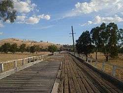
In 1896 the third configuration of the bridge was completed. The northern spans and southern approach spans were all replaced. The northern spans were replaced by seventy-five spans of 9.14 m and one of 8.53 m, one of the longest timber beam bridges in Australia.[8] The alignment of this new approach was slightly to the west of the previous (second) northern approach. The two southern spans of 9.14 m dating from 1865 were replaced by one span of 10.7 m and one of 8.5 m on the same alignment as the previous southern approach spans.
In addition a side ramp was built on the western side in 1896, leading down from the bridge six spans north of the main spans down to ground level of the floodplain beneath the approach spans, as it had already become necessary to reduce wear and tear on the timber approach spans. After the 1896 reconstruction the bridge had a total length of 922 m, and remained the longest bridge in New South Wales until the opening of the Sydney Harbour Bridge in 1932.[1][9]
In 1977, the 1,143 metres (3,750 ft) long Sheahan Bridge, replaced the Prince Alfred Bridge as the Hume Highway crossing of the Murrumbidgee River. This bridge was duplicated in 2010.[10]
Since the opening of the Sheahan Bridge the Prince Alfred Bridge has served local traffic only, but since being superseded by the Sheahan Bridge the timber spans have deteriorated to such an extent that the 1896 side ramp has had to be reinstated, so that most of the northern approach is disused, and has deteriotated to the point where it is closed not only to vehicular traffic but also to pedestrians.
References
![]() Media related to Prince Alfred Bridge at Wikimedia Commons
Media related to Prince Alfred Bridge at Wikimedia Commons
- 1 2 "Prince Alfred Bridge over Murrumbidgee River". Heritage and conservation register. Roads and Traffic Authority (NSW). 2004. Retrieved 2008-03-10.
- ↑ 'Main Roads' Vol 2 No 6 Feb 1932 p.87
- ↑ "Prince Alfred Bridge Over Murrumbidgee River". Heritage Branch. New South Wales Government. Retrieved 31 May 2011.
- ↑ "THE GUNDAGAI BRIDGE.". The Argus (Melbourne, Vic. : 1848 - 1957). Melbourne, Vic.: National Library of Australia. 24 May 1867. p. 5. Retrieved 12 August 2015.
- ↑ "To the Editor of the Herald". The Sydney Morning Herald. National Library of Australia. 16 December 1868. p. 6. Retrieved 16 September 2011.
- ↑ Main Roads op. cit.
- ↑ Kendall, George Henry. "Bridge across the Murrumbidgee, Gundagai". State Library of Victoria. Retrieved 2 August 2014.
- ↑ Historic Bridges of Gundagai, IE Aust, Historic Engineering Marker
- ↑ "Prince Alfred Bridge, Gundagai, NSW, Australia (Place ID 703)". Australian Heritage Database. Department of the Environment. Retrieved 2008-03-10.
- ↑ "Sheahan Bridge". Department of Infrastructure, Transport, Regional Development and Local Government. Nation Building program. Archived from the original on October 24, 2009. Retrieved 2009-06-29.
Coordinates: 35°04′12″S 148°06′31″E / 35.07°S 148.1086°E