Promontory of Quebec
The promontory of Quebec refers to the area on which is built a part a Quebec City, namely the upper part of the borough of La Cité-Limoilou. The promontory lies on the southeastern side of a larger plateau attested in French language as colline de Québec or Quebec hill, on the west of which is located most of the borough of Sainte-Foy–Sillery–Cap-Rouge.
History
Its steep escarpments have always been a challenge for the city because of the rockslide risk or by seeking ways to connect upper and lower town.[1] Nowadays, with the addition of roads, 30 stairs, a free escalator and a funicular unite lower and upper town. Furthermore, 53 landslides causing 88 fatalities, such as the rockslide of 1889, have been recorded since 1775, although mitigation measures were implemented during the 20th century which reduced the number of incidents.[2]
Geography
The plateau, which includes the promontory of Quebec, is 13 kilometres (8.1 mi) long and has a maximum width of 4 kilometres (2.5 mi). It is bounded to the northeast by the Saint-Charles River and to the southeast by the Saint Lawrence River. In the area just below the Plains of Abraham, where is situated Cap Diamant, the slopes contains mostly cedars as well as some broadleaf trees.[3]
Geologically, the Quebec hill is a nappe of the Appalachian mountains as well as its only intrusion on the north side of the Saint-Lawrence River.[4] On the northern side of the plateau, runs the Logan's Fault, a prominent area of thrust faulting in northeastern North America first documented by William Logan,[5] marking the boundary between the geologic province of the appalachian and of the Saint Lawrence Lowlands.[6]
Gallery
-

Topographic map of the plateau
-

Escalier des Glacis stairs
-
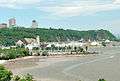
View from the Saint Lawrence's cove of Anse-au-Foulon with Cap Diamant on the east
-

Faubourg escalator and stairs
References
- ↑ "Champlain Street below the Citadel, Quebec City, QC, 1865". McCord Museum.
- ↑ F . Baillifard; et al. (2004). "Towards a GIS-based rockfall hazard assessment along the Quebec City Promontory". Landslides: Evaluation and Stabilization. CRC Press. pp. 208–. ISBN 978-0-415-35665-7.
- ↑ "Falaise du promontoire de Québec, secteur du Cap-Blanc". Parcs et espaces naturels des régions de Québec et Chaudière- Appalaches (in French).
- ↑ Baillargeon, Guy (1981). Zonation et modification de la composition de la flore vasculaire dans un région urbaine : la colline de Québec. (PDF) (Thesis) (in French). Université Laval. p. 9.
- ↑ "Upper Town / Lower Town: A Major Geological Fault". Canadian Geoscience Education Network.
- ↑ "Québec fortified City: Geological and Historical Heritage Fieldtrip Guidebook" (PDF). Government of Canada Publications. 2005.
Coordinates: 46°46′19″N 71°18′07″W / 46.7720°N 71.3020°W