Puca Mauras
For the volcano on the border of the Andagua District and the Chilcaymarca District, Castilla Province, Arequipa Region, Peru, see Puca Mauras (Andagua-Chilcaymarca).
| Puca Mauras | |
|---|---|
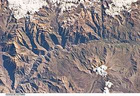 The Colca River and Puca Mauras northwest of it (at the left rim of this image) as seen from the ISS | |
| Highest point | |
| Elevation | 4,955 m (16,257 ft) [1] |
| Coordinates | 15°27′13″S 72°13′49″W / 15.45361°S 72.23028°WCoordinates: 15°27′13″S 72°13′49″W / 15.45361°S 72.23028°W |
| Geography | |
 Puca Mauras Peru | |
| Location | Peru, Arequipa Region, Castilla Province, Chachas District |
| Parent range | Andes, Chila |
Puca Mauras or Puka Mawras (Quechua puka red,[2] hispanicized spelling Pucamauras) is a 4,955-metre-high (16,257 ft) volcano in the Andes of Peru. It is situated in the Arequipa Region, Castilla Province, Chachas District.[3] Puca Mauras lies in the western extensions of the Chila mountain range, west of a lake named Cochapunco (Qucha P'unqu).
References
- ↑ "Cerro Pucamauras". IGN, Peru. Retrieved August 6, 2015.
- ↑ Teofilo Laime Ajacopa, Diccionario Bilingüe Iskay simipi yuyayk'ancha, La Paz, 2007 (Quechua-Spanish dictionary)
- ↑ escale.minedu.gob.pe - UGEL Map of the Castilla Province (1) (Arequipa Region)
This article is issued from Wikipedia - version of the 10/7/2016. The text is available under the Creative Commons Attribution/Share Alike but additional terms may apply for the media files.