Puddefjord Bridge
| Puddefjord Bridge | |
|---|---|
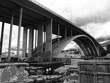 The Puddefjord Bridge, viewed from the Gyldenpris side. | |
| Coordinates | 60°23′03″N 5°19′02″E / 60.3841°N 5.3171°ECoordinates: 60°23′03″N 5°19′02″E / 60.3841°N 5.3171°E |
| Carries |
Six lanes on Highway 555 Cyclists Pedestrians |
| Crosses | Puddefjord |
| Locale | Bergen, Norway |
| Official name | Puddefjordsbroen |
| Characteristics | |
| Design | Arch bridge |
| Total length | 461 m (1,512.5 ft) |
| Longest span | 150 m (492.1 ft) |
| History | |
| Opened | 1956 |
The Puddefjord Bridge (Norwegian: Puddefjordsbroen) is an arch bridge in Bergen, Norway. It consists of two directly adjacent, near-identical bridges, the first of which was built in 1956 and the second in 1999. The bridge carries six lanes of motor vehicles and two cycle/footpaths across the Puddefjorden in central Bergen, between Møhlenpris in the city centre and Gyldenpris in Årstad borough. Although it does not have official motorway status, it is an important part of the city's motorway network, linking the westbound motorway, Sotraveien, to European route E39.
The bridge was important in the development of the Fyllingsdalen valley, which was annexed by Bergen in 1955. It also served as a more convenient road to the city centre for the residents of Laksevåg, who prior to its construction had to drive through Danmarksplass or take the ferry across the Puddefjord.
As of 2012, the bridge carried a daily average traffic of 56,098 vehicles.[1]
References
- ↑ "Årsdøgnstrafikk - Hordaland" (in Norwegian). Statens Vegvesen. Retrieved 2009-07-17.